TopoQuest Logo
Do you find TopoQuest useful?
Help keep TopoQuest running and adding new maps/features by donating!
Bitcoin:  19c7KJd3qBynnjoSw5npx9KScwjBe4ifkT
Litecoin:  LXs6TkuXGGXo1vDsWCkWVdjQX94eUKd6ui
Home View Maps Find Maps Find Places Resources & Links


Culberson, North Carolina Topographic Map

USGS Map Title: Culberson, NC
USGS Map MRC: 34084H2
DRG (GeoTIFF) Download: o34084h2.tif


Neighboring USGS Topographic Map Quads:


  Isabella, TN  
35084A3
 

  Persimmon Creek, NC  
35084A2
 

  Murphy, NC  
35084A1
 

  Mineral Bluff, GA  
34084H3
 

  Culberson, NC  
34084H2
 

  Nottely Dam, GA  
34084H1
 

  Blue Ridge, GA  
34084G3
 

  Wilscot, GA  
34084G2
 

  Mulky Gap, GA  
34084G1


Map MRC Location:

N35°
W85°
N35°
W84°
H8 H7 H6 H5 H4 H3 H2 H1
G8 G7 G6 G5 G4 G3 G2 G1
F8 F7 F6 F5 F4 F3 F2 F1
E8 E7 E6 E5 E4 E3 E2 E1
D8 D7 D6 D5 D4 D3 D2 D1
C8 C7 C6 C5 C4 C3 C2 C1
B8 B7 B6 B5 B4 B3 B2 B1
A8 A7 A6 A5 A4 A3 A2 A1
N34°
W85°
N34°
W84°

Culberson, NC USGS 1:24K Topographic Map Preview:
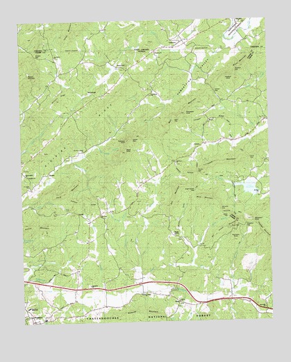
Culberson, NC USGS Topographic Map
Click on map above to begin viewing in our Map Viewer.

This topographic map contains these locations and features:
Feature Name Type Latitude Longitude GNIS ID View Map
Apostolic Gospel ChurchChurchN34.8870°W84.1880°330946View Map
Appalachia ChurchChurchN34.8901°W84.2157°330947View Map
Bald Knob School (historical)SchoolN34.9023°W84.2388°351078View Map
Beck BranchStreamN34.9168°W84.1994°330929View Map
Bell SchoolSchoolN34.9790°W84.2252°327064View Map
Bethel ChurchChurchN34.8834°W84.1710°354635View Map
Bill Hunter MountainSummitN34.9134°W84.1460°330931View Map
Brown MillPopulated PlaceN34.9240°W84.2463°331253View Map
Bruce MountainRidgeN34.9798°W84.1413°327239View Map
Bruce SchoolSchoolN34.9587°W84.1524°327240View Map
Bryan CreekStreamN34.8906°W84.1891°327247View Map
Bryan MillPopulated PlaceN34.8979°W84.1724°331263View Map
Chestnut GapGapN34.9154°W84.1363°327440View Map
Chigger RidgeRidgeN34.9598°W84.1544°327451View Map
City of MorgantonCivilN34.8757°W84.2444°2404303View Map
Cook CreekStreamN34.8848°W84.1474°327513View Map
Coon GapGapN34.9123°W84.1424°327519View Map
CulbersonPopulated PlaceN34.9917°W84.1677°1010605View Map
Culberson Post OfficePost OfficeN34.9903°W84.1669°2766610View Map
Culberson Volunteer Fire DepartmentBuildingN34.9894°W84.1700°2638990View Map
CutcanePopulated PlaceN34.9365°W84.2371°331501View Map
Cutcane Church (historical)ChurchN34.9448°W84.2224°351085View Map
Cutcane RidgeRidgeN34.9254°W84.2199°327579View Map
Cutcane SchoolSchoolN34.9459°W84.2180°327580View Map
Dan MountainSummitN34.9262°W84.1727°333215View Map
Darneille GapGapN34.9215°W84.1499°327596View Map
Davenport KnobSummitN34.9173°W84.1335°327600View Map
Dividing RidgeRidgeN34.9579°W84.2182°327655View Map
Dora (historical)Populated PlaceN34.9317°W84.1902°351088View Map
East Fannin Elementary SchoolSchoolN34.8813°W84.2474°330948View Map
Ellis Mill (historical)LocaleN34.9695°W84.1427°1730647View Map
Falling Down BranchStreamN34.9484°W84.2121°330935View Map
Fannin County Fire Department Station 10BuildingN34.9755°W84.2003°2604213View Map
Fannin County Fire Department Station 8BuildingN34.8895°W84.1713°2603563View Map
Flint Grove SchoolSchoolN34.9259°W84.1905°327850View Map
Flint Hill ChurchChurchN34.9179°W84.2071°327851View Map
Flint Mill School (historical)SchoolN34.9173°W84.2163°351100View Map
Forge MillPopulated PlaceN34.8934°W84.2463°331745View Map
Friendship ChurchChurchN34.9870°W84.1816°355964View Map
Galloway BranchStreamN34.8965°W84.1921°327909View Map
Hamestring ValleyValleyN34.9886°W84.1445°328044View Map
Hamstring ValleyValleyN34.9915°W84.1457°1011827View Map
Harper ChurchChurchN34.9695°W84.1835°328071View Map
Harper SchoolSchoolN34.9773°W84.1816°328076View Map
Hawkins GapGapN34.9798°W84.1416°328090View Map
Hawkins KnobSummitN34.9767°W84.1449°330943View Map
Hawkins Mill (historical)LocaleN34.9840°W84.2349°1730633View Map
HempPopulated PlaceN34.8834°W84.1719°356253View Map
Hemp ChurchChurchN34.8868°W84.1877°328102View Map
Hemp SchoolSchoolN34.8837°W84.1455°356254View Map
Hemp School (historical)SchoolN34.8868°W84.1863°351105View Map
Hemptown ChurchChurchN34.8820°W84.1713°351107View Map
High TopSummitN34.9595°W84.1719°356288View Map
Hogback MountainRidgeN34.9087°W84.1255°328182View Map
Holiness ChurchChurchN34.9054°W84.1674°328194View Map
Hunter BranchStreamN34.8984°W84.1657°328257View Map
Hurricane KnobSummitN34.9112°W84.1427°330934View Map
Hyatt CemeteryCemeteryN34.9990°W84.1377°1018172View Map
Jerusalem CemeteryCemeteryN34.9323°W84.2452°330926View Map
Jerusalem ChurchChurchN34.9359°W84.2466°328317View Map
Jerusalem School (historical)SchoolN34.9348°W84.2408°351114View Map
Jones BranchStreamN34.9134°W84.1563°330945View Map
Jones CemeteryCemeteryN34.9217°W84.2260°330927View Map
Jones TopSummitN34.9198°W84.1460°330933View Map
Jonica GapGapN34.9709°W84.1521°328363View Map
Lake WoodruffLakeN34.9299°W84.1353°330940View Map
Lance GapGapN34.9440°W84.1366°330942View Map
Lance MillPopulated PlaceN34.9479°W84.1430°332180View Map
Lance Mill (historical)LocaleN34.9473°W84.1430°353127View Map
Lance MountainSummitN34.9409°W84.1482°328442View Map
LewnerPopulated PlaceN34.9490°W84.1577°332209View Map
Liberty Hill ChurchChurchN34.8806°W84.1277°328506View Map
Locust GapGapN34.9506°W84.1938°328597View Map
Long ChapelChurchN34.9226°W84.2485°328628View Map
LovingPopulated PlaceN34.9201°W84.2210°332273View Map
Loving SchoolSchoolN34.9129°W84.2238°328654View Map
Mack MountainRidgeN34.9195°W84.1460°329976View Map
Maple GrovePopulated PlaceN34.9104°W84.1710°332314View Map
Maple Grove ChurchChurchN34.9095°W84.1710°351119View Map
Mashburn MillPopulated PlaceN34.8906°W84.1355°332327View Map
McCulloughPopulated PlaceN34.9698°W84.2132°332345View Map
Mill BranchStreamN34.8856°W84.1446°328775View Map
Millpond RidgeRidgeN34.9673°W84.2316°328807View Map
Mineral Bluff DivisionCivilN34.9421°W84.2406°1936411View Map
Mitchell BranchStreamN34.8862°W84.1457°328823View Map
Morganton Baptist ChurchChurchN34.8779°W84.2463°351128View Map
Morganton SchoolSchoolN34.8765°W84.2391°351129View Map
Mount Carmel ChurchChurchN34.9326°W84.1891°351130View Map
Mount Herman ChurchChurchN34.9698°W84.1838°330944View Map
Mount Olive ChurchChurchN34.9273°W84.1307°330939View Map
Mount Olivet CemeteryCemeteryN34.9270°W84.1305°353138View Map
Mount Olivet SchoolSchoolN34.9273°W84.1305°328885View Map
Mull CreekStreamN34.9543°W84.1291°328954View Map
Mull MountainRidgeN34.9634°W84.1663°328955View Map
New Hope CemeteryCemeteryN34.9187°W84.2082°351132View Map
New Hope ChurchChurchN34.9190°W84.2105°330930View Map
New Liberty ChurchChurchN34.9854°W84.2321°329016View Map
New Mount Gilead ChurchChurchN34.9462°W84.2180°330936View Map
Norman CoveValleyN34.9041°W84.1632°330932View Map
Oak Grove CemeteryCemeteryN34.9401°W84.1719°353152View Map
Oak Grove ChurchChurchN34.9409°W84.1721°329071View Map
Old Jerusalem ChurchChurchN34.9362°W84.2480°330928View Map
Owenby CreekStreamN34.9917°W84.1457°1027439View Map
Paris CemeteryCemeteryN34.9201°W84.2321°329132View Map
Paris MountainSummitN34.9290°W84.2288°329133View Map
Patterson KnobSummitN34.9501°W84.1957°330937View Map
PearlPopulated PlaceN34.9590°W84.1549°330941View Map
Pleasant Gap ChurchChurchN34.9267°W84.2116°329250View Map
Poindexter KnobSummitN34.9615°W84.1669°329281View Map
Pounding Mill BranchStreamN34.8995°W84.2466°329315View Map
Raper KnobSummitN34.9454°W84.1971°330938View Map
Richards BranchStreamN34.8859°W84.1646°329423View Map
Richards MountainRidgeN34.8779°W84.1910°329424View Map
River Valley ChurchChurchN34.9990°W84.1380°1018174View Map
Robert W Woodruff Scout ReservationLocaleN34.9337°W84.1374°353175View Map
Rocky Gap (historical)Populated PlaceN34.9737°W84.2355°351144View Map
Sparks MillPopulated PlaceN34.8951°W84.1449°333098View Map
Sweet GumPopulated PlaceN34.9812°W84.2007°333174View Map
Sweetgum ChurchChurchN34.9798°W84.1969°351149View Map
Tarpley BranchStreamN34.9426°W84.2235°329934View Map
Thomas MillPopulated PlaceN34.9312°W84.1380°329975View Map
Thomas MountainSummitN34.9215°W84.1427°335841View Map
Tri - State School of TheologySchoolN34.8778°W84.2460°2545797View Map
Turner GapGapN34.9370°W84.1607°330082View Map
Van Hook ChurchChurchN34.9431°W84.2271°351158View Map
Virgil Hunter GapGapN34.9295°W84.1621°329973View Map
Watson GapGapN34.9856°W84.2419°330180View Map
Watson Gap (historical)Populated PlaceN34.9840°W84.2319°351159View Map
Watson MountainSummitN34.9779°W84.2469°330181View Map
Williams BranchStreamN34.8881°W84.2105°330290View Map
Wright MillPopulated PlaceN34.9101°W84.1921°333473View Map
Wright Mill BranchStreamN34.8926°W84.1885°330387View Map
Zion Hill CemeteryCemeteryN34.9584°W84.1260°353205View Map
Zion Hill ChurchChurchN34.9587°W84.1257°330427View Map

Note: Coordinates in the location and feature list above are referenced to NAD83 datum.


Copyright (C) 2008-2024 Ryan Niemi / Sunset Dynamics ... All Rights Reserved