TopoQuest Logo
Do you find TopoQuest useful?
Help keep TopoQuest running and adding new maps/features by donating!
Bitcoin:  19c7KJd3qBynnjoSw5npx9KScwjBe4ifkT
Litecoin:  LXs6TkuXGGXo1vDsWCkWVdjQX94eUKd6ui
Home View Maps Find Maps Find Places Resources & Links


De Leon, Texas Topographic Map

USGS Map Title: De Leon, TX
USGS Map MRC: 32098A5
DRG (GeoTIFF) Download: o32098a5.tif


Neighboring USGS Topographic Map Quads:


  Gorman, TX  
32098B6
 

  Rucker, TX  
32098B5
 

  Lingleville, TX  
32098B4
 

  Duster, TX  
32098A6
 

  De Leon, TX  
32098A5
 

  Comyn, TX  
32098A4
 

  Sidney, TX  
31098H6
 

  Comanche, TX  
31098H5
 

  Proctor, TX  
31098H4


Map MRC Location:

N33°
W99°
N33°
W98°
H8 H7 H6 H5 H4 H3 H2 H1
G8 G7 G6 G5 G4 G3 G2 G1
F8 F7 F6 F5 F4 F3 F2 F1
E8 E7 E6 E5 E4 E3 E2 E1
D8 D7 D6 D5 D4 D3 D2 D1
C8 C7 C6 C5 C4 C3 C2 C1
B8 B7 B6 B5 B4 B3 B2 B1
A8 A7 A6 A5 A4 A3 A2 A1
N32°
W99°
N32°
W98°

De Leon, TX USGS 1:24K Topographic Map Preview:
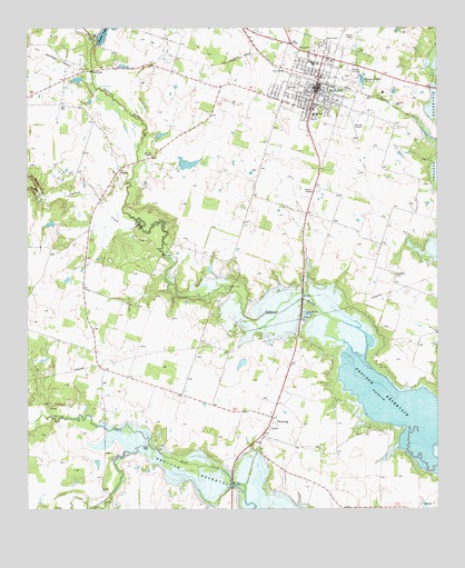
De Leon, TX USGS Topographic Map
Click on map above to begin viewing in our Map Viewer.

This topographic map contains these locations and features:
Feature Name Type Latitude Longitude GNIS ID View Map
A G Lee DamDamN32.0968°W98.5853°1861090View Map
A G Lee LakeReservoirN32.0972°W98.5850°1861091View Map
Bible Baptist ChurchChurchN32.1071°W98.5503°2017530View Map
Church of ChristChurchN32.1168°W98.5325°2017537View Map
City of De LeonCivilN32.1114°W98.5352°2410304View Map
Copperas CreekStreamN32.0168°W98.5878°1333336View Map
De LeonPopulated PlaceN32.1110°W98.5359°1334129View Map
De Leon City HallBuildingN32.1084°W98.5368°2753509View Map
De Leon DivisionCivilN32.1118°W98.6029°1938675View Map
De Leon Elementary SchoolSchoolN32.1024°W98.5384°2004842View Map
De Leon High SchoolSchoolN32.1149°W98.5384°2004843View Map
De Leon HospitalHospitalN32.1060°W98.5381°2015549View Map
De Leon Municipal Airport (historical)AirportN32.0988°W98.5253°1386528View Map
De Leon Police DepartmentBuildingN32.1089°W98.5375°2750257View Map
De Leon Post OfficePost OfficeN32.1183°W98.5401°2731177View Map
De Leon Volunteer Fire DepartmentBuildingN32.1087°W98.5390°2551855View Map
DowningPopulated PlaceN32.0240°W98.5506°1378224View Map
E J Alderman DamDamN32.0001°W98.5670°1861157View Map
Ebenezer CemeteryCemeteryN32.0611°W98.5136°1335058View Map
First Baptist ChurchChurchN32.1085°W98.5362°2017532View Map
Golden DamDamN32.0901°W98.5787°1861088View Map
Golden LakeReservoirN32.0898°W98.5765°1861089View Map
Jerry Solomon DamDamN32.0401°W98.5653°1863624View Map
Jerry Solomon LakeReservoirN32.0396°W98.5665°1863625View Map
Lesley Lake Number 2ReservoirN32.0005°W98.5412°1864241View Map
Lesley Lake Number 2 DamDamN32.0001°W98.5403°1864240View Map
Louise Post OfficePost OfficeN32.1183°W98.5401°2731697View Map
McGinnis DamDamN32.0385°W98.5503°1861086View Map
McGinnis LakeReservoirN32.0388°W98.5496°1861087View Map
Morton ChapelChurchN32.0921°W98.5870°1341955View Map
Nabors Lake DamDamN32.1235°W98.6037°1861084View Map
North Turkey CreekStreamN32.0821°W98.6206°1342822View Map
Northside Baptist ChurchChurchN32.1146°W98.5325°2017535View Map
Perkins Middle SchoolSchoolN32.1146°W98.5384°2004847View Map
PoundsLocaleN32.0882°W98.5970°1344445View Map
Sabana RiverStreamN32.0401°W98.5223°1375871View Map
Skaggs DamDamN32.0518°W98.5803°1861092View Map
Skaggs LakeReservoirN32.0524°W98.5814°1861093View Map
South Turkey CreekStreamN32.0818°W98.6206°1347539View Map
Spruill Dam Number 1DamN32.1118°W98.6087°1861082View Map
Spruill Dam Number 2DamN32.1168°W98.6153°1862709View Map
Spruill Lake Number 1ReservoirN32.1117°W98.6101°1861083View Map
Spruill Lake Number 2ReservoirN32.1168°W98.6153°1862710View Map
Sweetwater CreekStreamN32.0168°W98.5878°1348142View Map
Turkey CreekStreamN32.0735°W98.5898°1348859View Map
United Pentecostal ChurchChurchN32.1165°W98.5339°2017541View Map

Note: Coordinates in the location and feature list above are referenced to NAD83 datum.


Copyright (C) 2008-2024 Ryan Niemi / Sunset Dynamics ... All Rights Reserved