TopoQuest Logo
Do you find TopoQuest useful?
Help keep TopoQuest running and adding new maps/features by donating!
Bitcoin:  19c7KJd3qBynnjoSw5npx9KScwjBe4ifkT
Litecoin:  LXs6TkuXGGXo1vDsWCkWVdjQX94eUKd6ui
Home View Maps Find Maps Find Places Resources & Links


Duncan, Nebraska Topographic Map

USGS Map Title: Duncan, NE
USGS Map MRC: 41097D4
DRG (GeoTIFF) Download: o41097d4.tif


Neighboring USGS Topographic Map Quads:


  Tarnov, NE  
41097E5
 

  Platte Center, NE  
41097E4
 

  Humphrey SE, NE  
41097E3
 

  Monroe, NE  
41097D5
 

  Duncan, NE  
41097D4
 

  Columbus, NE  
41097D3
 

  Silver Creek SE, NE  
41097C5
 

  Columbus SW, NE  
41097C4
 

  Columbus SE, NE  
41097C3


Map MRC Location:

N42°
W98°
N42°
W97°
H8 H7 H6 H5 H4 H3 H2 H1
G8 G7 G6 G5 G4 G3 G2 G1
F8 F7 F6 F5 F4 F3 F2 F1
E8 E7 E6 E5 E4 E3 E2 E1
D8 D7 D6 D5 D4 D3 D2 D1
C8 C7 C6 C5 C4 C3 C2 C1
B8 B7 B6 B5 B4 B3 B2 B1
A8 A7 A6 A5 A4 A3 A2 A1
N41°
W98°
N41°
W97°

Duncan, NE USGS 1:24K Topographic Map Preview:
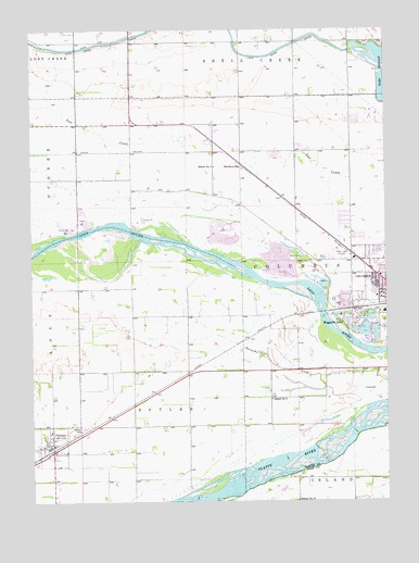
Duncan, NE USGS Topographic Map
Click on map above to begin viewing in our Map Viewer.

This topographic map contains these locations and features:
Feature Name Type Latitude Longitude GNIS ID View Map
Administration BuildingBuildingN41.4770°W97.3800°1881013View Map
Bible Baptist Christian SchoolSchoolN41.4339°W97.3789°1880980View Map
Bible Baptist ChurchChurchN41.4339°W97.3789°1880948View Map
Bradshaw Park Softball ComplexParkN41.4328°W97.3864°1880922View Map
Central Community College - Platte CampusSchoolN41.4764°W97.3803°1881040View Map
Church of GodChurchN41.4445°W97.3878°1880955View Map
Church of the NazareneChurchN41.4436°W97.3825°1880971View Map
College View ParkPopulated PlaceN41.4458°W97.3920°1880910View Map
Columbus Community HospitalHospitalN41.4553°W97.3848°1880891View Map
Columbus ManorHospitalN41.4428°W97.3756°1880895View Map
Country Shadows Golf CourseLocaleN41.4806°W97.3864°1880927View Map
Countryview EstatesPopulated PlaceN41.4458°W97.3920°1880911View Map
Dialysis Center of ColumbusHospitalN41.4400°W97.3750°1880894View Map
DuncanLocaleN41.3883°W97.4934°1881024View Map
DuncanPopulated PlaceN41.3895°W97.4948°828887View Map
Duncan 1871-1971 Historical MarkerParkN41.3895°W97.4948°1881020View Map
Duncan Elementary SchoolSchoolN41.3897°W97.4964°1881025View Map
Duncan Fire DepartmentBuildingN41.3893°W97.4944°2553387View Map
Duncan Post OfficePost OfficeN41.3897°W97.4935°1881023View Map
East Education CenterBuildingN41.4764°W97.3800°1881010View Map
Elks Country Club Golf CourseLocaleN41.4806°W97.3920°1880928View Map
Everlasting Love MinistriesChurchN41.4428°W97.3864°1880953View Map
Faculty CenterBuildingN41.4761°W97.3803°1881011View Map
Fine Arts CenterBuildingN41.4772°W97.3800°1881014View Map
Fountain SquareParkN41.4297°W97.3753°829366View Map
Freedom Baptist ChurchChurchN41.4339°W97.3756°1880972View Map
Gerrard ParkParkN41.4445°W97.3795°1880920View Map
GreenhouseBuildingN41.4761°W97.3789°1881019View Map
Highland Park Evangelical Free ChurchChurchN41.4528°W97.3767°1880960View Map
Husker Co-op ElevatorLocaleN41.3895°W97.4948°1881022View Map
Jackson CemeteryCemeteryN41.3947°W97.4825°830328View Map
KJSK-AM (Columbus)TowerN41.4367°W97.3967°837768View Map
KTTT-AM (Columbus)TowerN41.4539°W97.4059°837770View Map
KWMG-FM (Columbus)TowerN41.4539°W97.4059°837798View Map
Lakeview Census Designated PlaceCensusN41.4997°W97.3775°2587008View Map
Loup River CanalCanalN41.4950°W97.4884°830923View Map
Maintenance WarehouseBuildingN41.4775°W97.3781°1881018View Map
North Education CenterBuildingN41.4786°W97.3800°1881016View Map
Physical Education CenterBuildingN41.4786°W97.3814°1881015View Map
Physical Plant OfficesBuildingN41.4772°W97.3784°1881017View Map
Resource CenterBuildingN41.4758°W97.3800°1881012View Map
Saint Isidore Catholic ChurchChurchN41.4356°W97.3756°1880950View Map
Saint Stanislaus ChurchChurchN41.3895°W97.4948°1881021View Map
School Number 16SchoolN41.4317°W97.4839°836286View Map
School Number 17SchoolN41.3750°W97.4067°836297View Map
School Number 3SchoolN41.4639°W97.4353°836538View Map
School Number 5SchoolN41.4020°W97.4156°836812View Map
SheldonvillePopulated PlaceN41.4639°W97.4259°833375View Map
SheldonvilleLocaleN41.4639°W97.4259°1880835View Map
Student CenterBuildingN41.4758°W97.3809°1881008View Map
The Church of Jesus Christ of Latter Day SaintsChurchN41.4486°W97.3795°1880957View Map
Township of ColumbusCivilN41.4593°W97.4262°837934View Map
Van Berg Municipal Golf CourseLocaleN41.4222°W97.3759°1880930View Map
Village of DuncanCivilN41.3901°W97.4934°2398753View Map
Wagners LakePopulated PlaceN41.4220°W97.3856°834417View Map
Wagners LakeLakeN41.4202°W97.3863°1880819View Map
West Education CenterBuildingN41.4764°W97.3809°1881009View Map
West Park Elementary SchoolSchoolN41.4361°W97.3784°1880979View Map

Note: Coordinates in the location and feature list above are referenced to NAD83 datum.


Copyright (C) 2008-2024 Ryan Niemi / Sunset Dynamics ... All Rights Reserved