TopoQuest Logo
Do you find TopoQuest useful?
Help keep TopoQuest running and adding new maps/features by donating!
Bitcoin:  19c7KJd3qBynnjoSw5npx9KScwjBe4ifkT
Litecoin:  LXs6TkuXGGXo1vDsWCkWVdjQX94eUKd6ui
Home View Maps Find Maps Find Places Resources & Links


Elkland, Missouri Topographic Map

USGS Map Title: Elkland, MO
USGS Map MRC: 37093D1
DRG (GeoTIFF) Download: o37093d1.tif


Neighboring USGS Topographic Map Quads:


  Halfway, MO  
37093E2
 

  Charity, MO  
37093E1
 

  Long Lane, MO  
37092E8
 

  Fair Grove, MO  
37093D2
 

  Elkland, MO  
37093D1
 

  Beach, MO  
37092D8
 

  Bassville, MO  
37093C2
 

  Strafford, MO  
37093C1
 

  Marshfield, MO  
37092C8


Map MRC Location:

N38°
W94°
N38°
W93°
H8 H7 H6 H5 H4 H3 H2 H1
G8 G7 G6 G5 G4 G3 G2 G1
F8 F7 F6 F5 F4 F3 F2 F1
E8 E7 E6 E5 E4 E3 E2 E1
D8 D7 D6 D5 D4 D3 D2 D1
C8 C7 C6 C5 C4 C3 C2 C1
B8 B7 B6 B5 B4 B3 B2 B1
A8 A7 A6 A5 A4 A3 A2 A1
N37°
W94°
N37°
W93°

Elkland, MO USGS 1:24K Topographic Map Preview:
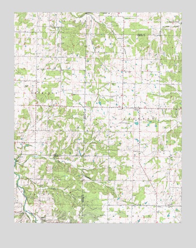
Elkland, MO USGS Topographic Map
Click on map above to begin viewing in our Map Viewer.

This topographic map contains these locations and features:
Feature Name Type Latitude Longitude GNIS ID View Map
Atteberry CemeteryCemeteryN37.4500°W93.0532°713472View Map
Blumenstetter AirportAirportN37.4358°W93.0668°2679323View Map
Cedar Bluff ChurchChurchN37.3773°W93.1038°715569View Map
ConklinPopulated PlaceN37.3853°W93.0191°740761View Map
Davis CemeteryCemeteryN37.4581°W93.0516°716710View Map
Dugan DamDamN37.4350°W93.0318°764576View Map
Eads Ridge AirportAirportN37.4056°W93.0980°2679326View Map
ElklandPopulated PlaceN37.4431°W93.0310°717471View Map
Elkland Fire Protection DistrictBuildingN37.4436°W93.0348°2621406View Map
Elkland Post OfficePost OfficeN37.4431°W93.0343°2782827View Map
Elkland SchoolSchoolN37.4431°W93.0441°717472View Map
Free Will ChapelChurchN37.4559°W93.1177°718193View Map
Hannon Lake DamDamN37.4900°W93.0352°765429View Map
Minor School (historical)LocaleN37.3778°W93.0468°742320View Map
Mission ChapelChurchN37.4848°W93.0438°722462View Map
Mount Olive CemeteryCemeteryN37.4668°W93.1046°2681498View Map
Mount Olive ChurchChurchN37.4662°W93.1049°722813View Map
Mutton HollowValleyN37.4114°W93.1235°723092View Map
Old Goss School (historical)LocaleN37.4234°W93.1099°742321View Map
Old Pleasant View CemeteryCemeteryN37.4342°W93.0396°723774View Map
OlivePopulated PlaceN37.4592°W93.1088°755562View Map
Olive SchoolSchoolN37.4659°W93.1007°742322View Map
Pleasant Ridge ChurchChurchN37.4142°W93.1230°724584View Map
Pleasant View ChurchChurchN37.4173°W93.0318°724645View Map
Selph BranchStreamN37.4020°W93.1210°726195View Map
Stever BranchStreamN37.4973°W93.0671°727090View Map
Stever CemeteryCemeteryN37.4648°W93.0399°727091View Map
Timber Ridge ChurchChurchN37.3850°W93.0096°727667View Map
Township of JacksonCivilN37.4371°W93.0206°767532View Map
Union Mound ChurchChurchN37.4912°W93.0952°728026View Map

Note: Coordinates in the location and feature list above are referenced to NAD83 datum.


Copyright (C) 2008-2024 Ryan Niemi / Sunset Dynamics ... All Rights Reserved