TopoQuest Logo
Do you find TopoQuest useful?
Help keep TopoQuest running and adding new maps/features by donating!
Bitcoin:  19c7KJd3qBynnjoSw5npx9KScwjBe4ifkT
Litecoin:  LXs6TkuXGGXo1vDsWCkWVdjQX94eUKd6ui
Home View Maps Find Maps Find Places Resources & Links


Elkton, Missouri Topographic Map

USGS Map Title: Elkton, MO
USGS Map MRC: 37093G4
DRG (GeoTIFF) Download: o37093g4.tif


Neighboring USGS Topographic Map Quads:


  Weaubleau, MO  
37093H5
 

  Wheatland, MO  
37093H4
 

  Hermitage, MO  
37093H3
 

  Humansville, MO  
37093G5
 

  Elkton, MO  
37093G4
 

  Sentinel, MO  
37093G3
 

  Fair Play, MO  
37093F5
 

  Cliquot, MO  
37093F4
 

  Polk, MO  
37093F3


Map MRC Location:

N38°
W94°
N38°
W93°
H8 H7 H6 H5 H4 H3 H2 H1
G8 G7 G6 G5 G4 G3 G2 G1
F8 F7 F6 F5 F4 F3 F2 F1
E8 E7 E6 E5 E4 E3 E2 E1
D8 D7 D6 D5 D4 D3 D2 D1
C8 C7 C6 C5 C4 C3 C2 C1
B8 B7 B6 B5 B4 B3 B2 B1
A8 A7 A6 A5 A4 A3 A2 A1
N37°
W94°
N37°
W93°

Elkton, MO USGS 1:24K Topographic Map Preview:
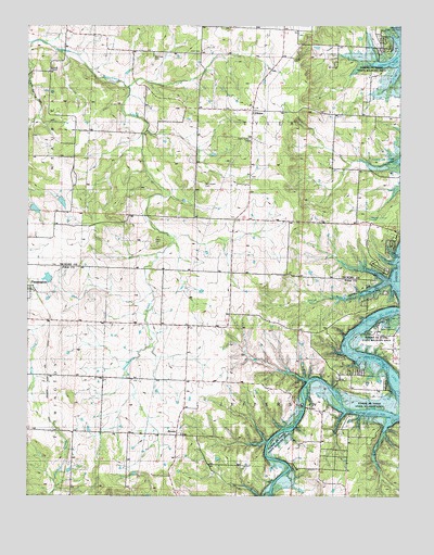
Elkton, MO USGS Topographic Map
Click on map above to begin viewing in our Map Viewer.

This topographic map contains these locations and features:
Feature Name Type Latitude Longitude GNIS ID View Map
Bolivar Public Use AreaParkN37.7936°W93.3760°741402View Map
Cave Spring HollowValleyN37.8686°W93.4999°715552View Map
Cook CemeteryCemeteryN37.8684°W93.4444°716218View Map
Durnell ChapelChurchN37.8625°W93.4935°717209View Map
ElktonPopulated PlaceN37.8525°W93.4260°717473View Map
Elkton SchoolSchoolN37.8523°W93.4321°717474View Map
Fairview SchoolSchoolN37.7673°W93.4980°735614View Map
Green Grove School (historical)SchoolN37.7536°W93.3946°718792View Map
Horn HollowValleyN37.8075°W93.3791°719833View Map
Humansville Fire and Rescue Station 2BuildingN37.7821°W93.3937°2620713View Map
Leiman CemeteryCemeteryN37.8664°W93.4127°720902View Map
Mashburn SchoolSchoolN37.8625°W93.3833°729774View Map
McCracken CemeteryCemeteryN37.8328°W93.4424°722065View Map
Mission ChapelChurchN37.7664°W93.4485°722463View Map
Prairie Valley School (historical)SchoolN37.8242°W93.4319°729804View Map
RondoPopulated PlaceN37.7661°W93.4499°725547View Map
Rondo SchoolSchoolN37.7586°W93.4502°725548View Map
Rountree CemeteryCemeteryN37.8667°W93.4602°758444View Map
Royal SchoolSchoolN37.8361°W93.3802°725644View Map
Shady Grove School (historical)SchoolN37.8503°W93.4894°726247View Map
Stacey BranchStreamN37.8075°W93.3791°726984View Map
Sunny Slope School (historical)SchoolN37.8223°W93.4919°727304View Map
Tillery CemeteryCemeteryN37.8167°W93.4569°727658View Map
Township of JeffersonCivilN37.7692°W93.4249°767216View Map
Township of TylerCivilN37.8601°W93.4128°766758View Map
Union SchoolSchoolN37.7953°W93.4402°728037View Map
Vanderford Number Three DamDamN37.8267°W93.4902°763538View Map
Vanderford Number Two DamDamN37.8300°W93.4902°763247View Map
West BranchStreamN37.7706°W93.3766°728530View Map
Wheatland Volunteer Fire Department Elkton Station 2BuildingN37.8523°W93.4292°2620735View Map

Note: Coordinates in the location and feature list above are referenced to NAD83 datum.


Copyright (C) 2008-2024 Ryan Niemi / Sunset Dynamics ... All Rights Reserved