TopoQuest Logo
Do you find TopoQuest useful?
Help keep TopoQuest running and adding new maps/features by donating!
Bitcoin:  19c7KJd3qBynnjoSw5npx9KScwjBe4ifkT
Litecoin:  LXs6TkuXGGXo1vDsWCkWVdjQX94eUKd6ui
Home View Maps Find Maps Find Places Resources & Links


Elkton, Oregon Topographic Map

USGS Map Title: Elkton, OR
USGS Map MRC: 43123F5
DRG (GeoTIFF) Download: o43123f5.tif


Neighboring USGS Topographic Map Quads:


  Twin Sisters, OR  
43123G6
 

  Gunter, OR  
43123G5
 

  Beaver Creek, OR  
43123G4
 

  Devils Graveyard, OR  
43123F6
 

  Elkton, OR  
43123F5
 

  Putnam Valley, OR  
43123F4
 

  Old Blue, OR  
43123E6
 

  Kellogg, OR  
43123E5
 

  Yellow Butte, OR  
43123E4


Map MRC Location:

N44°
W124°
N44°
W123°
H8 H7 H6 H5 H4 H3 H2 H1
G8 G7 G6 G5 G4 G3 G2 G1
F8 F7 F6 F5 F4 F3 F2 F1
E8 E7 E6 E5 E4 E3 E2 E1
D8 D7 D6 D5 D4 D3 D2 D1
C8 C7 C6 C5 C4 C3 C2 C1
B8 B7 B6 B5 B4 B3 B2 B1
A8 A7 A6 A5 A4 A3 A2 A1
N43°
W124°
N43°
W123°

Elkton, OR USGS 1:24K Topographic Map Preview:
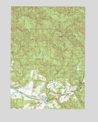
Elkton, OR USGS Topographic Map
Click on map above to begin viewing in our Map Viewer.

This topographic map contains these locations and features:
Feature Name Type Latitude Longitude GNIS ID View Map
Beaver CreekStreamN43.6446°W123.6059°1117421View Map
Big Tom Folley CreekStreamN43.6721°W123.5132°1128145View Map
Bower CreekStreamN43.6443°W123.6082°1132941View Map
Buzzard Bay County ParkParkN43.6373°W123.5734°1162529View Map
City of ElktonCivilN43.6378°W123.5688°2410429View Map
Elk CreekStreamN43.6337°W123.5673°1120443View Map
Elk Creek Guard StationLocaleN43.6498°W123.5126°1120450View Map
Elk Creek Tunnel 3437TunnelN43.6558°W123.5085°2668481View Map
Elk Creek Tunnel Forest State ParkParkN43.6540°W123.5112°1120452View Map
ElktonPopulated PlaceN43.6376°W123.5682°1120478View Map
Elkton CemeteryCemeteryN43.6285°W123.5632°1132940View Map
Elkton Christian ChurchChurchN43.6378°W123.5678°2508118View Map
Elkton City HallBuildingN43.6368°W123.5661°2661378View Map
Elkton Community Education CenterBuildingN43.6418°W123.5796°2661172View Map
Elkton Grade SchoolSchoolN43.6418°W123.5795°2417815View Map
Elkton High SchoolSchoolN43.6381°W123.5706°2417816View Map
Elkton PondReservoirN43.6464°W123.5867°1638440View Map
Elkton Post OfficePost OfficeN43.6368°W123.5654°1165209View Map
Elkton Public WorksBuildingN43.6368°W123.5661°2661556View Map
Elkton Rural Fire Protection DistrictBuildingN43.6341°W123.5632°2576715View Map
Elkton Wastewater Treatment FacilityLocaleN43.6409°W123.5817°2660785View Map
Elkton Water Treatment PlantLocaleN43.6344°W123.5646°2660800View Map
Grubbe CreekStreamN43.6373°W123.5748°1161672View Map
Haines CreekStreamN43.6276°W123.5665°1132939View Map
Hancock CreekStreamN43.6426°W123.5379°1121549View Map
Hancock HillSummitN43.6435°W123.5458°1160481View Map
Hancock MountainSummitN43.6606°W123.5112°1160482View Map
Hart CreekStreamN43.6407°W123.5901°1121635View Map
Henderer CemeteryCemeteryN43.6398°W123.6216°1132942View Map
House CreekStreamN43.6873°W123.6207°1132945View Map
Little Tom Folley CreekStreamN43.6593°W123.5529°1123298View Map
Saddle ButteSummitN43.7116°W123.5409°1160480View Map
Saddle Butte CreekStreamN43.6901°W123.5220°1132943View Map

Note: Coordinates in the location and feature list above are referenced to NAD83 datum.


Copyright (C) 2008-2024 Ryan Niemi / Sunset Dynamics ... All Rights Reserved