TopoQuest Logo
Do you find TopoQuest useful?
Help keep TopoQuest running and adding new maps/features by donating!
Bitcoin:  19c7KJd3qBynnjoSw5npx9KScwjBe4ifkT
Litecoin:  LXs6TkuXGGXo1vDsWCkWVdjQX94eUKd6ui
Home View Maps Find Maps Find Places Resources & Links


Florence, Arizona Topographic Map

USGS Map Title: Florence, AZ
USGS Map MRC: 33111A4
DRG (GeoTIFF) Download: o33111a4.tif


Neighboring USGS Topographic Map Quads:


  Sacaton NE, AZ  
33111B5
 

  Magma, AZ  
33111B4
 

  Florence NE, AZ  
33111B3
 

  Blackwater, AZ  
33111A5
 

  Florence, AZ  
33111A4
 

  Florence SE, AZ  
33111A3
 

  Coolidge, AZ  
32111H5
 

  Valley Farms, AZ  
32111H4
 

  Cactus Forest, AZ  
32111H3


Map MRC Location:

N34°
W112°
N34°
W111°
H8 H7 H6 H5 H4 H3 H2 H1
G8 G7 G6 G5 G4 G3 G2 G1
F8 F7 F6 F5 F4 F3 F2 F1
E8 E7 E6 E5 E4 E3 E2 E1
D8 D7 D6 D5 D4 D3 D2 D1
C8 C7 C6 C5 C4 C3 C2 C1
B8 B7 B6 B5 B4 B3 B2 B1
A8 A7 A6 A5 A4 A3 A2 A1
N33°
W112°
N33°
W111°

Florence, AZ USGS 1:24K Topographic Map Preview:
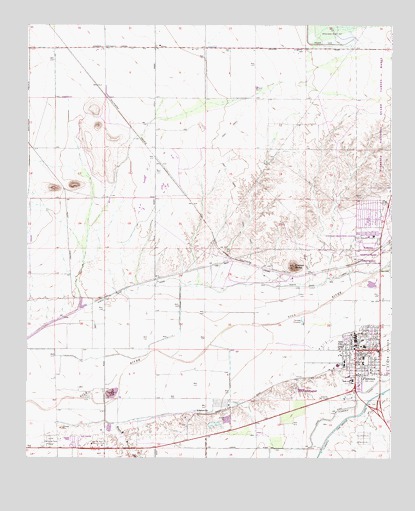
Florence, AZ USGS Topographic Map
Click on map above to begin viewing in our Map Viewer.

This topographic map contains these locations and features:
Feature Name Type Latitude Longitude GNIS ID View Map
AdamsvillePopulated PlaceN33.0128°W111.4421°24293View Map
Adamsville CemeteryCemeteryN33.0238°W111.4087°23643View Map
Anthem K - 8 SchoolSchoolN33.0579°W111.4752°2545009View Map
Arizona State Prison Florence WestBuildingN33.0371°W111.3766°2751613View Map
Arriola SquareLocaleN33.0333°W111.3874°2721206View Map
Bogart WashStreamN33.0098°W111.4701°1783View Map
Dorothy Nolan Senior CenterBuildingN33.0349°W111.3860°2670349View Map
First Presbyterian Church of FlorenceChurchN33.0310°W111.3850°2670997View Map
FlorencePopulated PlaceN33.0315°W111.3873°4688View Map
Florence Baptist ChurchChurchN33.0314°W111.3897°2671032View Map
Florence CemeteryCemeteryN33.0058°W111.3846°4692View Map
Florence Community Healthcare FacilityHospitalN33.0269°W111.3937°23777View Map
Florence Fire DepartmentBuildingN33.0390°W111.3863°2672371View Map
Florence Gardens Mobile Home ParkPopulated PlaceN33.0709°W111.3832°2669662View Map
Florence High SchoolSchoolN33.0226°W111.3892°23706View Map
Florence K - 8 SchoolSchoolN33.0275°W111.3841°23704View Map
Florence Police DepartmentBuildingN33.0357°W111.3859°2672267View Map
Florence Post OfficePost OfficeN33.0362°W111.3871°2669929View Map
Florence StationLocaleN33.0562°W111.3890°23705View Map
Florence Town HallBuildingN33.0389°W111.3873°2669585View Map
Highway ParkParkN33.0245°W111.3879°23715View Map
Ho Ho Kam Country ClubLocaleN33.0034°W111.4754°43186View Map
Magma DamDamN33.1195°W111.3985°7589View Map
North Side CanalCanalN33.0473°W111.4629°8762View Map
Oasis Golf ClubLocaleN33.0916°W111.4981°2669909View Map
Pinal County Juvenile Detention CenterSchoolN33.0268°W111.3937°2544954View Map
Pinal County Sheriff's OfficeBuildingN33.0413°W111.3760°2672296View Map
Poston ButteSummitN33.0551°W111.4087°9682View Map
Poston Butte Golf ClubLocaleN33.0684°W111.4631°2670041View Map
The Church of Jesus Christ of Latter Day SaintsChurchN33.0208°W111.3883°2671928View Map
Three Parks FairwaysLocaleN33.0720°W111.3781°2669920View Map
Town of FlorenceCivilN33.0590°W111.4208°2412633View Map
Town of Florence North Florence Wastewater Treatment PlantLocaleN33.0635°W111.3870°2669625View Map
Town of Florence Wastewater Treatment PlantLocaleN33.0290°W111.4074°2669626View Map
Union Baptist ChurchChurchN33.0382°W111.3803°2671403View Map
Valley Memorial Park CemeteryCemeteryN33.0047°W111.4927°23837View Map
Whispering Wind Mobile Home ParkPopulated PlaceN33.0045°W111.4842°2670301View Map

Note: Coordinates in the location and feature list above are referenced to NAD83 datum.


Copyright (C) 2008-2024 Ryan Niemi / Sunset Dynamics ... All Rights Reserved