TopoQuest Logo
Do you find TopoQuest useful?
Help keep TopoQuest running and adding new maps/features by donating!
Bitcoin:  19c7KJd3qBynnjoSw5npx9KScwjBe4ifkT
Litecoin:  LXs6TkuXGGXo1vDsWCkWVdjQX94eUKd6ui
Home View Maps Find Maps Find Places Resources & Links


Fort Knox, Kentucky Topographic Map

USGS Map Title: Fort Knox, KY
USGS Map MRC: 37085H8
DRG (GeoTIFF) Download: o37085h8.tif


Neighboring USGS Topographic Map Quads:


  Laconia, IN  
38086A1
 

  Kosmosdale, KY  
38085A8
 

  Valley Station, KY  
38085A7
 

  Rock Haven, KY  
37086H1
 

  Fort Knox, KY  
37085H8
 

  Pitts Point, KY  
37085H7
 

  Flaherty, KY  
37086G1
 

  Vine Grove, KY  
37085G8
 

  Colesburg, KY  
37085G7


Map MRC Location:

N38°
W86°
N38°
W85°
H8 H7 H6 H5 H4 H3 H2 H1
G8 G7 G6 G5 G4 G3 G2 G1
F8 F7 F6 F5 F4 F3 F2 F1
E8 E7 E6 E5 E4 E3 E2 E1
D8 D7 D6 D5 D4 D3 D2 D1
C8 C7 C6 C5 C4 C3 C2 C1
B8 B7 B6 B5 B4 B3 B2 B1
A8 A7 A6 A5 A4 A3 A2 A1
N37°
W86°
N37°
W85°

Fort Knox, KY USGS 1:24K Topographic Map Preview:
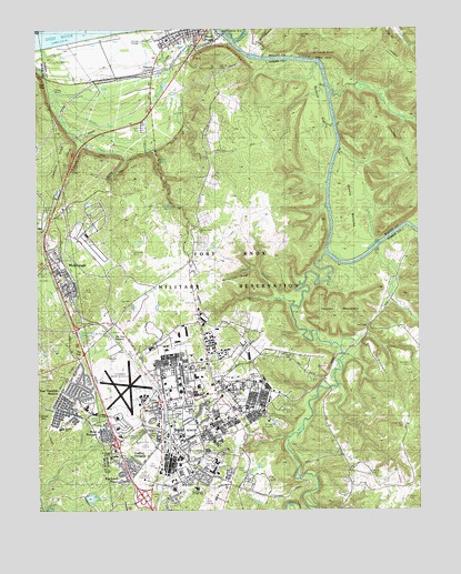
Fort Knox, KY USGS Topographic Map
Click on map above to begin viewing in our Map Viewer.

This topographic map contains these locations and features:
Feature Name Type Latitude Longitude GNIS ID View Map
Anderson Golf CourseLocaleN37.8753°W85.9433°517086View Map
Arnold BottomsBendN37.9553°W85.8991°486049View Map
Arnold RocksSummitN37.9928°W85.9100°486057View Map
Bleakley CemeteryCemeteryN37.9151°W85.9752°509507View Map
Boone CemeteryCemeteryN37.9659°W85.9897°487685View Map
Briscoe SchoolSchoolN37.8915°W85.9552°487915View Map
Burcham CemeteryCemeteryN37.9126°W85.8777°488403View Map
Burnett FlatFlatN37.9792°W85.9069°488446View Map
Buzzard RoostSummitN37.9945°W85.9086°488546View Map
Calvin CemeteryCemeteryN37.8998°W85.9252°488651View Map
Cameron RidgeRidgeN37.9667°W85.9927°488662View Map
Canby HillSummitN37.9145°W85.9189°488757View Map
Cedar Grove CemeteryCemeteryN37.8967°W85.8800°489196View Map
Cedar Point BranchStreamN37.9837°W85.9036°489236View Map
Chappel RidgeRidgeN37.9615°W85.8758°489360View Map
City of MuldraughCivilN37.9366°W85.9915°2404337View Map
City of West PointCivilN37.9850°W85.9557°2405715View Map
Cornwell FieldParkN37.9009°W85.9541°490129View Map
Crittenberger SchoolSchoolN37.8942°W85.9727°490354View Map
Crystal LakeReservoirN37.9576°W85.9929°2742586View Map
Davis CemeteryCemeteryN37.9290°W85.9475°490654View Map
Davis CemeteryCemeteryN37.8857°W85.9350°509505View Map
Dickerson LakeReservoirN37.9208°W85.9865°490878View Map
Dripping SpringsSpringN37.9539°W85.9549°491122View Map
Dry BranchStreamN37.8901°W85.9850°491152View Map
Easy GapGapN37.9228°W85.8916°491527View Map
Eisenhower ChapelChurchN37.9056°W85.9358°509508View Map
Field CemeteryCemeteryN37.9684°W85.9413°492063View Map
Fort Hill CemeteryCemeteryN37.9798°W85.9280°492354View Map
Fort Hill City ParkParkN37.9928°W85.9402°509513View Map
Fort KnoxMilitaryN37.9010°W85.9020°2512204View Map
Fort Knox Census Designated PlaceCensusN37.8916°W85.9636°2402497View Map
Fort Knox DivisionCivilN37.8868°W85.8916°2583514View Map
Fort Knox Fire Division Station 1BuildingN37.8930°W85.9509°2636893View Map
Gaffey HeightsPopulated PlaceN37.8859°W85.9689°492647View Map
Gander BranchStreamN37.8759°W85.9986°492670View Map
Gentry CemeteryCemeteryN37.8848°W85.8913°492774View Map
Geoghegan CemeteryCemeteryN37.9978°W85.9588°492776View Map
Godman Army AirfieldAirportN37.9054°W85.9670°517378View Map
Godman ChapelChurchN37.9028°W85.9608°492933View Map
Golf CourseLocaleN37.8881°W85.9650°517163View Map
Hart CemeteryCemeteryN37.9153°W85.9750°493837View Map
Heard ParkParkN37.9012°W85.9200°509512View Map
High SchoolSchoolN37.8853°W85.9425°494192View Map
Hilltop ChapelChurchN37.9017°W85.9336°494279View Map
Hooker MountainSummitN37.9267°W85.9014°494503View Map
HowardPopulated PlaceN37.9890°W85.9608°508286View Map
Ireland Army Community HospitalHospitalN37.9004°W85.9418°495000View Map
Johnson BranchStreamN37.9301°W85.9189°495365View Map
Johnson CemeteryCemeteryN37.9981°W85.9133°495389View Map
Kingsolver SchoolSchoolN37.9015°W85.9494°495768View Map
Long CemeteryCemeteryN37.9795°W85.9280°497089View Map
MacDonald Junior High SchoolSchoolN37.8809°W85.9469°509509View Map
March RidgeRidgeN37.9109°W85.9894°497528View Map
McClelland RidgeRidgeN37.9353°W85.9339°497785View Map
McCormick CemeteryCemeteryN37.9951°W85.9883°497804View Map
McIntire CemeteryCemeteryN37.9620°W85.9791°497884View Map
Mill CreekStreamN37.9417°W85.9052°498262View Map
Montgomery CemeteryCemeteryN37.9215°W85.9763°498505View Map
Mudge SchoolSchoolN37.8962°W85.9916°509510View Map
Muir HillSummitN37.9200°W85.9948°2742590View Map
MuldraughPopulated PlaceN37.9370°W85.9916°499075View Map
Muldraugh Fire DepartmentBuildingN37.9382°W85.9920°2636886View Map
Muldraugh Post OfficePost OfficeN37.9395°W85.9935°2460360View Map
Muth CemeteryCemeteryN37.9320°W85.9847°499141View Map
North Fork Dry BranchStreamN37.8900°W85.9851°2742591View Map
Phillips CemeteryCemeteryN37.8778°W85.8791°500535View Map
Pierce SchoolSchoolN37.8859°W85.9447°500576View Map
Pleasant View CemeteryCemeteryN37.9476°W85.9483°500940View Map
Pond CreekStreamN37.9987°W85.9383°501046View Map
Poplar SpringSpringN37.9661°W85.9603°501130View Map
Prewitts LakeLakeN37.9929°W85.9957°501315View Map
Prichard ChapelChurchN37.8890°W85.9758°501334View Map
Prichard PlacePopulated PlaceN37.8845°W85.9716°501338View Map
Ray CemeteryCemeteryN37.9295°W85.9691°501618View Map
Rose TerracePopulated PlaceN37.8951°W85.9772°502344View Map
Round HollowValleyN37.9700°W85.9858°502402View Map
Saint Patricks CemeteryCemeteryN37.8934°W85.9683°502710View Map
Scott Junior High SchoolSchoolN37.8876°W85.9411°503103View Map
Scott MountainSummitN37.9131°W85.8880°503104View Map
Stevens SchoolSchoolN37.8892°W85.9739°504369View Map
Sutherland CemeteryCemeteryN37.8903°W85.9460°509506View Map
The Armor CenterBuildingN37.8945°W85.9533°505106View Map
Thorne ParkParkN37.8787°W85.9614°505220View Map
Tioga CreekStreamN37.9840°W85.9939°505301View Map
Tioga SpringSpringN37.9617°W85.9747°505302View Map
Tip TopLocaleN37.9159°W85.9847°505303View Map
Tip Top StationLocaleN37.9203°W85.9747°505304View Map
Tobacco Leaf LakeReservoirN37.8783°W85.9831°505313View Map
Tollgate CreekStreamN37.9284°W85.9164°505326View Map
Turret FieldParkN37.9045°W85.9330°505685View Map
United States Bullion DepositoryLocaleN37.8834°W85.9652°517304View Map
Van Voorhis ManorPopulated PlaceN37.9053°W85.9891°505960View Map
VanVoorhis SchoolSchoolN37.9020°W85.9836°509511View Map
West PointPopulated PlaceN37.9995°W85.9436°506467View Map
West Point DivisionCivilN37.9897°W85.9655°1937314View Map
West Point Post OfficePost OfficeN37.9990°W85.9481°2460373View Map
Withers CemeteryCemeteryN37.9370°W85.9980°506972View Map

Note: Coordinates in the location and feature list above are referenced to NAD83 datum.


Copyright (C) 2008-2024 Ryan Niemi / Sunset Dynamics ... All Rights Reserved