TopoQuest Logo
Do you find TopoQuest useful?
Help keep TopoQuest running and adding new maps/features by donating!
Bitcoin:  19c7KJd3qBynnjoSw5npx9KScwjBe4ifkT
Litecoin:  LXs6TkuXGGXo1vDsWCkWVdjQX94eUKd6ui
Home View Maps Find Maps Find Places Resources & Links


Gladys, Virginia Topographic Map

USGS Map Title: Gladys, VA
USGS Map MRC: 37079B1
DRG (GeoTIFF) Download: o37079b1.tif


Neighboring USGS Topographic Map Quads:


  City Farm, VA  
37079C2
 

  Rustburg, VA  
37079C1
 

  Concord, VA  
37078C8
 

  Castle Craig, VA  
37079B2
 

  Gladys, VA  
37079B1
 

  Mike, VA  
37078B8
 

  Straightstone, VA  
37079A2
 

  Long Island, VA  
37079A1
 

  Brookneal, VA  
37078A8


Map MRC Location:

N38°
W80°
N38°
W79°
H8 H7 H6 H5 H4 H3 H2 H1
G8 G7 G6 G5 G4 G3 G2 G1
F8 F7 F6 F5 F4 F3 F2 F1
E8 E7 E6 E5 E4 E3 E2 E1
D8 D7 D6 D5 D4 D3 D2 D1
C8 C7 C6 C5 C4 C3 C2 C1
B8 B7 B6 B5 B4 B3 B2 B1
A8 A7 A6 A5 A4 A3 A2 A1
N37°
W80°
N37°
W79°

Gladys, VA USGS 1:24K Topographic Map Preview:
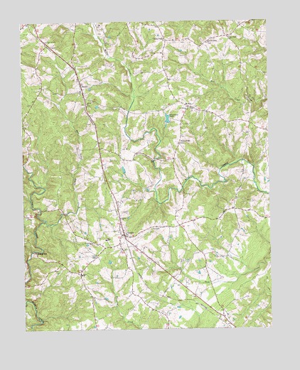
Gladys, VA USGS Topographic Map
Click on map above to begin viewing in our Map Viewer.

This topographic map contains these locations and features:
Feature Name Type Latitude Longitude GNIS ID View Map
Bethel Mennonite SchoolSchoolN37.1968°W79.0843°2498622View Map
Brookneal DistrictCivilN37.1306°W79.0046°1927117View Map
Brookneal/Campbell County AirportAirportN37.1390°W79.0186°1480220View Map
Calvary ChurchChurchN37.2168°W79.0917°1464277View Map
Campbell CountyCivilN37.2054°W79.0965°1674917View Map
Citizens Emergency CrewBuildingN37.1605°W79.0720°2721111View Map
Diamond HillPopulated PlaceN37.2010°W79.0450°1477262View Map
East Little Seneca CreekStreamN37.1693°W79.1136°1466109View Map
Farmer DamDamN37.1885°W79.0747°1489327View Map
First Saint Pauls ChurchChurchN37.2421°W79.1114°1466592View Map
GladysPopulated PlaceN37.1632°W79.0736°1467129View Map
Gladys Elementary SchoolSchoolN37.1617°W79.0832°1467130View Map
Gladys Post OfficePost OfficeN37.1632°W79.0726°2766214View Map
Gladys Volunteer Fire DepartmentBuildingN37.1600°W79.0716°2721151View Map
Grandview LakeReservoirN37.2106°W79.0510°1502027View Map
Grandview Lake DamDamN37.2085°W79.0514°1489328View Map
Kedron ChurchChurchN37.1701°W79.0756°1468922View Map
Mitchell MillPopulated PlaceN37.1565°W79.1189°1495064View Map
Mount ZionPopulated PlaceN37.2157°W79.0397°1471109View Map
New Chapel ChurchChurchN37.2435°W79.0189°1471405View Map
New Free Spring ChurchChurchN37.2413°W79.0300°1471416View Map
Oak Grove Church (historical)ChurchN37.2232°W79.1145°1674968View Map
Organ ChapelChurchN37.1551°W79.0881°1471949View Map
Saint Stephens ChurchChurchN37.2140°W79.0403°1473910View Map
Seneca SchoolSchoolN37.1474°W79.0959°1474168View Map
Three ForksPopulated PlaceN37.2426°W79.0509°1477809View Map
Wesleybury ChurchChurchN37.1604°W79.0900°1476469View Map
WinfallPopulated PlaceN37.2243°W79.0945°1477886View Map
Winfall NurseriesBuildingN37.2222°W79.0928°2677810View Map

Note: Coordinates in the location and feature list above are referenced to NAD83 datum.


Copyright (C) 2008-2024 Ryan Niemi / Sunset Dynamics ... All Rights Reserved