TopoQuest Logo
Do you find TopoQuest useful?
Help keep TopoQuest running and adding new maps/features by donating!
Bitcoin:  19c7KJd3qBynnjoSw5npx9KScwjBe4ifkT
Litecoin:  LXs6TkuXGGXo1vDsWCkWVdjQX94eUKd6ui
Home View Maps Find Maps Find Places Resources & Links


Goodson School, New Mexico Topographic Map

USGS Map Title: Goodson School, NM
USGS Map MRC: 36103H1
DRG (GeoTIFF) Download: o36103h1.tif


Neighboring USGS Topographic Map Quads:


  Furnish Canyon West, CO  
37103A2
 

  Furnish Canyon East, CO  
37103A1
 

  Big Hole Canyon, CO  
37102A8
 

  Wedding Cake Butte, NM  
36103H2
 

  Goodson School, NM  
36103H1
 

  Kenton, OK  
36102H8
 

  Atencio, NM  
36103G2
 

  Greendailey Canyon, NM  
36103G1
 

  Kenton SW, OK  
36102G8


Map MRC Location:

N37°
W104°
N37°
W103°
H8 H7 H6 H5 H4 H3 H2 H1
G8 G7 G6 G5 G4 G3 G2 G1
F8 F7 F6 F5 F4 F3 F2 F1
E8 E7 E6 E5 E4 E3 E2 E1
D8 D7 D6 D5 D4 D3 D2 D1
C8 C7 C6 C5 C4 C3 C2 C1
B8 B7 B6 B5 B4 B3 B2 B1
A8 A7 A6 A5 A4 A3 A2 A1
N36°
W104°
N36°
W103°

Goodson School, NM USGS 1:24K Topographic Map Preview:
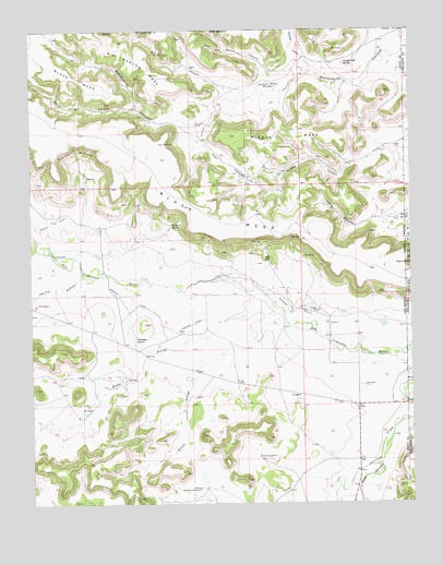
Goodson School, NM USGS Topographic Map
Click on map above to begin viewing in our Map Viewer.

This topographic map contains these locations and features:
Feature Name Type Latitude Longitude GNIS ID View Map
Big CanyonValleyN36.9824°W103.0529°196324View Map
Big Canyon MesaSummitN36.9917°W103.0877°898724View Map
Black Mesa ProspectMineN36.9417°W103.0508°916609View Map
Bontz ArroyoStreamN36.9225°W103.0419°886599View Map
Bramlett SpringSpringN36.9485°W103.0791°886705View Map
Ellmore CanyonValleyN36.9889°W103.0325°196325View Map
GoodsonLocaleN36.9189°W103.0933°928336View Map
Goodson SchoolSchoolN36.9186°W103.0919°889508View Map
Independence GroupMineN36.9264°W103.0305°916601View Map
Lone MesaSummitN36.9986°W103.0338°203882View Map
Long CanyonValleyN36.9509°W103.0108°891296View Map
Middle CanyonValleyN36.9686°W103.0083°891940View Map
Middle MesaSummitN36.9722°W103.0594°891960View Map
Negro SpringSpringN36.9381°W103.0006°1089497View Map
North CanyonValleyN36.9885°W103.0339°196376View Map
North Gillespie WindmillLocaleN36.8789°W103.0710°892602View Map
Potter ArroyoStreamN36.9197°W103.0669°893441View Map
Potter RinconSummitN36.9681°W103.1102°893444View Map
QuimbyLocaleN36.9239°W103.0683°928379View Map
Rabbit Ear Fire Department Kenton StationBuildingN36.9013°W103.0179°2657970View Map
Red HillSummitN36.9395°W103.0491°898844View Map
Rincon WindmillLocaleN36.8872°W103.0516°893961View Map
Road CanyonValleyN36.8851°W103.0119°910334View Map
Roberts DitchCanalN36.9292°W103.0958°894016View Map
Sloan CreekStreamN36.9428°W103.1235°894925View Map
Smiley ArroyoStreamN36.9359°W103.1088°894931View Map
South Fork CanyonValleyN36.9797°W103.0913°895043View Map
Sugarloaf ButteSummitN36.9911°W103.0222°899931View Map
Trail CanyonValleyN36.9711°W103.0685°895788View Map
Twin WindmillLocaleN36.9856°W103.0480°895971View Map
WhitleyLocaleN36.9920°W103.0383°928392View Map
WigginLocaleN36.9278°W103.0424°928411View Map
Wiggins Ralley Ditch Number 1CanalN36.9245°W103.0330°898198View Map

Note: Coordinates in the location and feature list above are referenced to NAD83 datum.


Copyright (C) 2008-2024 Ryan Niemi / Sunset Dynamics ... All Rights Reserved