TopoQuest Logo
Do you find TopoQuest useful?
Help keep TopoQuest running and adding new maps/features by donating!
Bitcoin:  19c7KJd3qBynnjoSw5npx9KScwjBe4ifkT
Litecoin:  LXs6TkuXGGXo1vDsWCkWVdjQX94eUKd6ui
Home View Maps Find Maps Find Places Resources & Links


Grand Bay, Alabama Topographic Map

USGS Map Title: Grand Bay, AL
USGS Map MRC: 30088D3
DRG (GeoTIFF) Download: o30088d3.tif


Neighboring USGS Topographic Map Quads:


  Big Point, MS  
30088E4
 

  Saint Elmo, AL  
30088E3
 

  Theodore, AL  
30088E2
 

  Kreole, MS  
30088D4
 

  Grand Bay, AL  
30088D3
 

  Coden, AL  
30088D2
 

  Grand Bay SW, AL  
30088C4
 

  Isle aux Herbes, AL  
30088C3
 

  Heron Bay, AL  
30088C2


Map MRC Location:

N31°
W89°
N31°
W88°
H8 H7 H6 H5 H4 H3 H2 H1
G8 G7 G6 G5 G4 G3 G2 G1
F8 F7 F6 F5 F4 F3 F2 F1
E8 E7 E6 E5 E4 E3 E2 E1
D8 D7 D6 D5 D4 D3 D2 D1
C8 C7 C6 C5 C4 C3 C2 C1
B8 B7 B6 B5 B4 B3 B2 B1
A8 A7 A6 A5 A4 A3 A2 A1
N30°
W89°
N30°
W88°

Grand Bay, AL USGS 1:24K Topographic Map Preview:
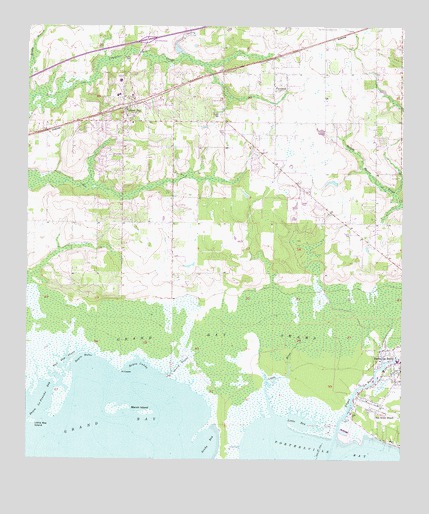
Grand Bay, AL USGS Topographic Map
Click on map above to begin viewing in our Map Viewer.

This topographic map contains these locations and features:
Feature Name Type Latitude Longitude GNIS ID View Map
Bayou BubieBayN30.4041°W88.3558°113599View Map
Bayou CaddyBayN30.4019°W88.3375°113600View Map
Bayou La BatreStreamN30.3816°W88.2717°154975View Map
Bayou La Batre ChurchChurchN30.4433°W88.2594°1729951View Map
Bayou La Fourche BayBayN30.3902°W88.3720°113607View Map
Bull Bay BayouGutN30.4027°W88.3620°115171View Map
Church of ChristChurchN30.4793°W88.3452°2580469View Map
City of Bayou La BatreCivilN30.4126°W88.2609°2403828View Map
Cora Castlen SchoolSchoolN30.4846°W88.3445°1729960View Map
Elizabeth ChurchChurchN30.4835°W88.3236°143315View Map
Faith Baptist ChurchChurchN30.4800°W88.3487°2579311View Map
FernlandPopulated PlaceN30.4833°W88.2931°118262View Map
First Assembly of God ChurchChurchN30.4804°W88.3333°2579309View Map
First Baptist Church of Grand BayChurchN30.4792°W88.3399°155488View Map
First Church of the NazareneChurchN30.4565°W88.2865°2579306View Map
First United Methodist ChurchChurchN30.4677°W88.3442°2579307View Map
Friendship Baptist ChurchChurchN30.4720°W88.3473°2579310View Map
Grand BayPopulated PlaceN30.4763°W88.3422°155081View Map
Grand BayBayN30.3849°W88.3472°119219View Map
Grand Bay CemeteryCemeteryN30.4626°W88.3479°119221View Map
Grand Bay Census Designated PlaceCensusN30.4717°W88.3450°2402543View Map
Grand Bay ChurchChurchN30.4560°W88.2861°1729980View Map
Grand Bay DivisionCivilN30.4807°W88.3186°165893View Map
Grand Bay Post OfficePost OfficeN30.4782°W88.3405°168248View Map
Grand Bay SwampSwampN30.4135°W88.3019°119222View Map
Grand Bay United Methodist ChurchChurchN30.4724°W88.3403°154664View Map
Grand Bay Volunteer Fire DepartmentBuildingN30.4747°W88.3436°2691084View Map
Grand BayouBayN30.4024°W88.3247°119223View Map
Grand Garden ChurchChurchN30.4491°W88.2781°143384View Map
H C Farmer DamDamN30.4935°W88.3267°129527View Map
Higher Ground Baptist ChurchChurchN30.4450°W88.2584°2580473View Map
Holy Assembly ChurchChurchN30.4521°W88.3270°143625View Map
Interchange 4CrossingN30.4960°W88.3356°155662View Map
J and J SpeedwayLocaleN30.4858°W88.3214°1729991View Map
Lighthouse ChurchChurchN30.4758°W88.2758°1729997View Map
Little BayBayN30.3863°W88.2839°121691View Map
Little Bay IslandIslandN30.3858°W88.3731°121692View Map
Little RiverStreamN30.3877°W88.2925°121859View Map
Little Rock ChurchChurchN30.4830°W88.2931°143496View Map
Marsh IslandIslandN30.3902°W88.3417°122302View Map
Mobile County High SchoolSchoolN30.4802°W88.3447°143544View Map
New Beginnings Ministry Baptist ChurchChurchN30.4770°W88.3283°2579308View Map
Pine Air ChurchChurchN30.4555°W88.2867°143655View Map
Pine Hill CemeteryCemeteryN30.4507°W88.3272°1730019View Map
PinecrestPopulated PlaceN30.4710°W88.3570°143660View Map
Piner McGrew CemeteryCemeteryN30.4508°W88.3309°2579312View Map
Point CaddyCapeN30.4005°W88.3436°125077View Map
Saint John's Catholic ChurchChurchN30.4748°W88.3355°2580468View Map
San Souci BeachPopulated PlaceN30.3888°W88.2583°153314View Map
Sandy BayBayN30.3788°W88.3156°126364View Map
Shiloh ChurchChurchN30.4588°W88.2911°143803View Map
Summit Mobile Home ParkPopulated PlaceN30.4517°W88.2829°2579821View Map
The Lord ChurchChurchN30.4866°W88.2767°1730037View Map

Note: Coordinates in the location and feature list above are referenced to NAD83 datum.


Copyright (C) 2008-2024 Ryan Niemi / Sunset Dynamics ... All Rights Reserved