TopoQuest Logo
Do you find TopoQuest useful?
Help keep TopoQuest running and adding new maps/features by donating!
Bitcoin:  19c7KJd3qBynnjoSw5npx9KScwjBe4ifkT
Litecoin:  LXs6TkuXGGXo1vDsWCkWVdjQX94eUKd6ui
Home View Maps Find Maps Find Places Resources & Links


Harrod, Ohio Topographic Map

USGS Map Title: Harrod, OH
USGS Map MRC: 40083F8
DRG (GeoTIFF) Download: o40083f8.tif


Neighboring USGS Topographic Map Quads:


  Cairo, OH  
40084G1
 

  Beaverdam, OH  
40083G8
 

  Ada, OH  
40083G7
 

  Lima, OH  
40084F1
 

  Harrod, OH  
40083F8
 

  Alger, OH  
40083F7
 

  Uniopolis, OH  
40084E1
 

  Waynesfield, OH  
40083E8
 

  Roundhead, OH  
40083E7


Map MRC Location:

N41°
W84°
N41°
W83°
H8 H7 H6 H5 H4 H3 H2 H1
G8 G7 G6 G5 G4 G3 G2 G1
F8 F7 F6 F5 F4 F3 F2 F1
E8 E7 E6 E5 E4 E3 E2 E1
D8 D7 D6 D5 D4 D3 D2 D1
C8 C7 C6 C5 C4 C3 C2 C1
B8 B7 B6 B5 B4 B3 B2 B1
A8 A7 A6 A5 A4 A3 A2 A1
N40°
W84°
N40°
W83°

Harrod, OH USGS 1:24K Topographic Map Preview:
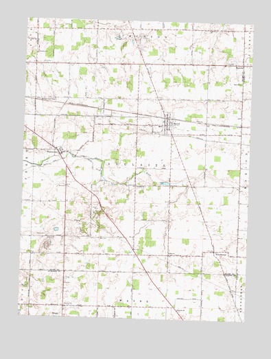
Harrod, OH USGS Topographic Map
Click on map above to begin viewing in our Map Viewer.

This topographic map contains these locations and features:
Feature Name Type Latitude Longitude GNIS ID View Map
Allen East Elementary SchoolSchoolN40.7062°W83.9255°1049770View Map
Auglaize CemeteryCemeteryN40.6812°W83.9372°1699302View Map
Auglaize ChurchChurchN40.6806°W83.9374°1037536View Map
Auglaize School (historical)SchoolN40.6878°W83.9380°1049769View Map
Baker School (historical)SchoolN40.7173°W83.9372°1049771View Map
Beaver Dam BranchStreamN40.6834°W83.9116°1063525View Map
Beaverdam School (historical)SchoolN40.6881°W83.8997°1049772View Map
Billtown School (historical)SchoolN40.6592°W83.9433°1049768View Map
Blair School (historical)SchoolN40.7312°W83.9755°1049767View Map
Fisher CemeteryCemeteryN40.7425°W83.9374°1040466View Map
Fisher School (historical)SchoolN40.7467°W83.9358°1049774View Map
Gossard School (historical)SchoolN40.6337°W83.8997°1071014View Map
HarrodPopulated PlaceN40.7064°W83.9213°1064802View Map
Harrod CemeteryCemeteryN40.7178°W83.9235°1041367View Map
Harrod Post OfficePost OfficeN40.7056°W83.9222°1957972View Map
Harrod Volunteer Fire and RescueBuildingN40.7086°W83.9227°2549510View Map
Hefner CemeteryCemeteryN40.7315°W83.9901°1041463View Map
Heidelberg ChurchChurchN40.7359°W83.9936°1041464View Map
High Street ChurchChurchN40.7467°W83.8994°1041550View Map
Hiptight School (historical)SchoolN40.6548°W83.9749°1049765View Map
Hopewell CemeteryCemeteryN40.6287°W83.9124°1071214View Map
Hopewell ChurchChurchN40.6289°W83.9127°1070781View Map
Horn CemeteryCemeteryN40.6395°W83.9749°1041793View Map
Hullibarger CemeteryCemeteryN40.7100°W83.9569°1041866View Map
Ice School (historical)SchoolN40.6762°W83.9755°1049766View Map
King RunStreamN40.7409°W83.8966°1048417View Map
Mars Hill CemeteryCemeteryN40.6301°W83.9752°1070838View Map
MaysvillePopulated PlaceN40.7326°W83.8799°1061489View Map
Maysville CemeteryCemeteryN40.7337°W83.8774°1699315View Map
Morris School (historical)SchoolN40.6295°W83.9761°1071015View Map
Mount Zion CemeteryCemeteryN40.6523°W83.9177°1699316View Map
Mount Zion ChurchChurchN40.6523°W83.9183°1043664View Map
Ridge CemeteryCemeteryN40.7174°W83.8991°1044998View Map
Ridge School (historical)SchoolN40.7176°W83.8997°1049773View Map
Salem CemeteryCemeteryN40.6778°W83.9622°1045878View Map
Shockey CemeteryCemeteryN40.6592°W83.9913°1046232View Map
Smith CemeteryCemeteryN40.6794°W83.9762°1046366View Map
Sugartree School (historical)SchoolN40.6298°W83.9377°1071016View Map
Township of AuglaizeCivilN40.6882°W83.9369°1085691View Map
Village of HarrodCivilN40.7075°W83.9213°2398256View Map
Ward CemeteryCemeteryN40.6582°W83.9566°1047559View Map
West NewtonPopulated PlaceN40.6539°W83.8927°1047785View Map
West Newton CemeteryCemeteryN40.6537°W83.8983°1699331View Map
West Newton Post Office (historical)Post OfficeN40.6542°W83.8916°1958004View Map
WestminsterPopulated PlaceN40.6934°W83.9802°1061763View Map
WestminsterLocaleN40.7159°W83.9916°1061764View Map
Westminster CemeteryCemeteryN40.6959°W83.9794°1699332View Map
Westminster Census Designated PlaceCensusN40.6990°W83.9795°2628986View Map
Westminster Post Office (historical)Post OfficeN40.6931°W83.9805°1958010View Map
Westminster Rural Fire DepartmentBuildingN40.6943°W83.9773°2550199View Map

Note: Coordinates in the location and feature list above are referenced to NAD83 datum.


Copyright (C) 2008-2024 Ryan Niemi / Sunset Dynamics ... All Rights Reserved