TopoQuest Logo
Do you find TopoQuest useful?
Help keep TopoQuest running and adding new maps/features by donating!
Bitcoin:  19c7KJd3qBynnjoSw5npx9KScwjBe4ifkT
Litecoin:  LXs6TkuXGGXo1vDsWCkWVdjQX94eUKd6ui
Home View Maps Find Maps Find Places Resources & Links


Honey Grove, Kentucky Topographic Map

USGS Map Title: Honey Grove, KY
USGS Map MRC: 36087H3
DRG (GeoTIFF) Download: o36087h3.tif


Neighboring USGS Topographic Map Quads:


  Crofton, KY  
37087A4
 

  Haleys Mill, KY  
37087A3
 

  Kirkmansville, KY  
37087A2
 

  Kelly, KY  
36087H4
 

  Honey Grove, KY  
36087H3
 

  Allegre, KY  
36087H2
 

  Hopkinsville, KY  
36087G4
 

  Pembroke, KY  
36087G3
 

  Elkton, KY  
36087G2


Map MRC Location:

N37°
W88°
N37°
W87°
H8 H7 H6 H5 H4 H3 H2 H1
G8 G7 G6 G5 G4 G3 G2 G1
F8 F7 F6 F5 F4 F3 F2 F1
E8 E7 E6 E5 E4 E3 E2 E1
D8 D7 D6 D5 D4 D3 D2 D1
C8 C7 C6 C5 C4 C3 C2 C1
B8 B7 B6 B5 B4 B3 B2 B1
A8 A7 A6 A5 A4 A3 A2 A1
N36°
W88°
N36°
W87°

Honey Grove, KY USGS 1:24K Topographic Map Preview:
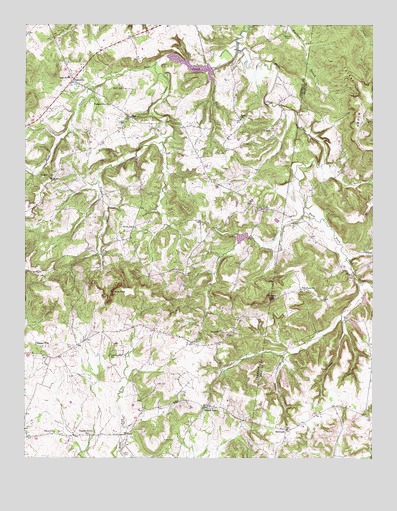
Honey Grove, KY USGS Topographic Map
Click on map above to begin viewing in our Map Viewer.

This topographic map contains these locations and features:
Feature Name Type Latitude Longitude GNIS ID View Map
BritmartPopulated PlaceN36.8831°W87.2811°487919View Map
Buck CreekStreamN36.9928°W87.2981°488210View Map
Buck Creek LakeReservoirN36.9885°W87.3161°2742877View Map
Caney CreekStreamN36.9459°W87.2744°488827View Map
CarlPopulated PlaceN36.9737°W87.3367°488934View Map
Ebenezer ChurchChurchN36.9117°W87.3033°491536View Map
FearsvillePopulated PlaceN36.9839°W87.3575°492011View Map
Flat Rock (historical)Populated PlaceN36.9239°W87.2752°2743142View Map
Flat Rock SchoolSchoolN36.9239°W87.2756°492211View Map
Forbes CreekStreamN36.9892°W87.3261°492299View Map
Goblers KnobSummitN36.9975°W87.3644°2742889View Map
Hayes CemeteryCemeteryN36.8806°W87.3217°493907View Map
Henderson CemeteryCemeteryN36.9567°W87.3644°494031View Map
Honey GrovePopulated PlaceN36.8898°W87.3097°494479View Map
Honey Grove Volunteer Fire DepartmentBuildingN36.8894°W87.3097°2636933View Map
Jones HollowValleyN36.9047°W87.2820°495504View Map
Lacy Elementary SchoolSchoolN36.9847°W87.3594°495898View Map
Lacy Volunteer Fire DepartmentBuildingN36.9833°W87.3582°2636937View Map
Laytonsville (historical)Populated PlaceN36.9062°W87.3423°2742894View Map
Laytonsville SchoolSchoolN36.9045°W87.3444°496105View Map
Martin CemeteryCemeteryN36.9817°W87.3392°497601View Map
O'Daniel CemeteryCemeteryN36.9695°W87.2842°499645View Map
OvilPopulated PlaceN36.9470°W87.2883°500051View Map
Perry (historical)Populated PlaceN36.8821°W87.3649°2742903View Map
Perry SchoolSchoolN36.8823°W87.3642°500433View Map
Pilot RockSummitN36.9212°W87.2861°500653View Map
Pine KnobSummitN36.9231°W87.3425°500698View Map
Pleasant HillPopulated PlaceN36.9073°W87.3686°508834View Map
Pleasant Hill Baptist ChurchChurchN36.9770°W87.3445°500856View Map
Shaw CemeteryCemeteryN36.8761°W87.3397°503273View Map
Shiloh SchoolSchoolN36.9420°W87.3356°503385View Map
Steel CemeteryCemeteryN36.8964°W87.3275°504299View Map
Tucker RidgeRidgeN36.9795°W87.2553°505544View Map
Tuckertown (historical)Populated PlaceN36.9750°W87.2527°2743149View Map
Turnpike HollowValleyN36.9150°W87.2606°505678View Map
Vaughn Grove ChurchChurchN36.8820°W87.3519°505997View Map
Weathers CemeteryCemeteryN36.9973°W87.2814°506317View Map
West Union (historical)Populated PlaceN36.9725°W87.2966°2742909View Map
West Union ChurchChurchN36.9729°W87.2975°506481View Map

Note: Coordinates in the location and feature list above are referenced to NAD83 datum.


Copyright (C) 2008-2024 Ryan Niemi / Sunset Dynamics ... All Rights Reserved