TopoQuest Logo
Do you find TopoQuest useful?
Help keep TopoQuest running and adding new maps/features by donating!
Bitcoin:  19c7KJd3qBynnjoSw5npx9KScwjBe4ifkT
Litecoin:  LXs6TkuXGGXo1vDsWCkWVdjQX94eUKd6ui
Home View Maps Find Maps Find Places Resources & Links


Humboldt, Iowa Topographic Map

USGS Map Title: Humboldt, IA
USGS Map MRC: 42094F2
DRG (GeoTIFF) Download: o42094f2.tif


Neighboring USGS Topographic Map Quads:


  Bode, IA  
42094G3
 

  Livermore, IA  
42094G2
 

  Hardy, IA  
42094G1
 

  Unique, IA  
42094F3
 

  Humboldt, IA  
42094F2
 

  Thor, IA  
42094F1
 

  Clare, IA  
42094E3
 

  Fort Dodge North, IA  
42094E2
 

  Vincent, IA  
42094E1


Map MRC Location:

N43°
W95°
N43°
W94°
H8 H7 H6 H5 H4 H3 H2 H1
G8 G7 G6 G5 G4 G3 G2 G1
F8 F7 F6 F5 F4 F3 F2 F1
E8 E7 E6 E5 E4 E3 E2 E1
D8 D7 D6 D5 D4 D3 D2 D1
C8 C7 C6 C5 C4 C3 C2 C1
B8 B7 B6 B5 B4 B3 B2 B1
A8 A7 A6 A5 A4 A3 A2 A1
N42°
W95°
N42°
W94°

Humboldt, IA USGS 1:24K Topographic Map Preview:
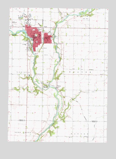
Humboldt, IA USGS Topographic Map
Click on map above to begin viewing in our Map Viewer.

This topographic map contains these locations and features:
Feature Name Type Latitude Longitude GNIS ID View Map
Abundant Life Christian FellowshipChurchN42.7264°W94.2191°1926109View Map
AddisonLocaleN42.6714°W94.2266°466284View Map
Addison Post Office (historical)Post OfficeN42.6708°W94.2266°1926080View Map
Beaver CreekStreamN42.6519°W94.1858°454449View Map
Beaver Township HallLocaleN42.6880°W94.1419°454463View Map
Bicknell ParkParkN42.7216°W94.2211°1926130View Map
City of Dakota CityCivilN42.7229°W94.1977°467672View Map
City of HumboldtCivilN42.7232°W94.2245°468059View Map
Congregational United Church of ChristChurchN42.7227°W94.2172°1926105View Map
Cottonwood TrailTrailN42.7227°W94.2289°1926117View Map
Dakota CityPopulated PlaceN42.7222°W94.1972°1690853View Map
Dakota City (historical)LocaleN42.7272°W94.2011°1926121View Map
Dakota City AccessLocaleN42.7172°W94.1891°1926111View Map
Dakota City City HallBuildingN42.7205°W94.2014°1926122View Map
Dakota City Post OfficePost OfficeN42.7211°W94.2019°1926123View Map
Dakota City River ParkParkN42.7236°W94.1939°1926139View Map
Dunscombe Dental ClinicHospitalN42.7214°W94.2133°1926098View Map
East Fork Des Moines RiverStreamN42.6772°W94.1983°456143View Map
Faith United Methodist ChurchChurchN42.7225°W94.2125°1926106View Map
Fay Hessian FountainParkN42.7183°W94.2152°1926134View Map
First Avenue Chiropractic CenterHospitalN42.7225°W94.2172°1926101View Map
Frank Gotch State ParkParkN42.6769°W94.2022°456720View Map
George Beebe ParkParkN42.7219°W94.2230°1926131View Map
Hampson Hillside ParkParkN42.7191°W94.2236°1926126View Map
Herb Zinnel ParkParkN42.7211°W94.2058°1926140View Map
Hovey CemeteryCemeteryN42.6297°W94.1733°1823229View Map
HumboldtPopulated PlaceN42.7208°W94.2152°457717View Map
Humboldt (historical)LocaleN42.7208°W94.2077°1926088View Map
Humboldt Care Center NorthHospitalN42.7339°W94.2250°1926102View Map
Humboldt Care Center SouthHospitalN42.7300°W94.2272°1926100View Map
Humboldt Chiropractic CenterHospitalN42.7214°W94.2133°1926097View Map
Humboldt City HallBuildingN42.7205°W94.2141°1926090View Map
Humboldt College (historical)SchoolN42.7208°W94.2152°1926062View Map
Humboldt County CourthouseBuildingN42.7216°W94.2050°1926120View Map
Humboldt County DragwayLocaleN42.7402°W94.1530°1926087View Map
Humboldt County FairgroundsLocaleN42.7300°W94.2114°1926113View Map
Humboldt County Historical MuseumBuildingN42.7227°W94.1913°1926128View Map
Humboldt County JailBuildingN42.7207°W94.2141°2333469View Map
Humboldt County Memorial HospitalHospitalN42.7327°W94.2320°1926095View Map
Humboldt Eye ClinicHospitalN42.7333°W94.2252°1926103View Map
Humboldt Fire DepartmentBuildingN42.7325°W94.2156°1926089View Map
Humboldt Fish HatcheryLocaleN42.7230°W94.2277°1926119View Map
Humboldt Group HomeHospitalN42.7247°W94.2211°1926099View Map
Humboldt High SchoolSchoolN42.7153°W94.2293°467210View Map
Humboldt Law Enforcement CenterBuildingN42.7208°W94.2141°1926091View Map
Humboldt Middle SchoolSchoolN42.7149°W94.2285°457718View Map
Humboldt Post OfficePost OfficeN42.7219°W94.2180°1926092View Map
Humboldt Public LibraryBuildingN42.7219°W94.2166°1926093View Map
Humbolt Junior High SchoolSchoolN42.7241°W94.2189°467211View Map
Indian CreekStreamN42.6764°W94.2133°465592View Map
Indian Mound CemeteryCemeteryN42.6880°W94.2077°457805View Map
Iowa ParkParkN42.7205°W94.2247°1926129View Map
Joe Reasoner DamDamN42.7269°W94.2291°457958View Map
John Brown ParkParkN42.7183°W94.2152°1926133View Map
Jones SidingPopulated PlaceN42.6800°W94.2080°464102View Map
KHBT-FM (Humboldt)TowerN42.7325°W94.2066°463737View Map
KRIT-FM (Clarion)TowerN42.6691°W94.1569°467306View Map
Lake NokomisReservoirN42.7269°W94.2291°459545View Map
Lake Nokomis ParkParkN42.7283°W94.2289°1926136View Map
Mease Elementary SchoolSchoolN42.7217°W94.2037°455492View Map
Oak Hill ChurchChurchN42.7108°W94.2258°1823231View Map
Oakwood CemeteryCemeteryN42.7083°W94.2086°1926145View Map
Our Saviours Lutheran ChurchChurchN42.7150°W94.2250°1926104View Map
Pedersen QuarryMineN42.7447°W94.1761°2611895View Map
Pioneer CemeteryCemeteryN42.6306°W94.1498°460184View Map
Rainbow Drive ParkParkN42.7347°W94.2294°1926138View Map
Reasoner DamDamN42.7269°W94.2291°1926114View Map
Riverside ParkParkN42.7114°W94.2197°1926124View Map
Saint Mary Catholic SchoolSchoolN42.7254°W94.2124°1823232View Map
Saint Mary's CemeteryCemeteryN42.7125°W94.2080°461178View Map
Saint Marys Catholic ChurchChurchN42.7252°W94.2127°1926107View Map
Saint Marys SchoolSchoolN42.7247°W94.2119°1926110View Map
Silver Creek Ski Area (historical)LocaleN42.7458°W94.1502°1926086View Map
Sylvan RetreatLocaleN42.6741°W94.1850°466283View Map
Sylvan Retreat Post Office (historical)Post OfficeN42.6741°W94.1850°1926067View Map
Taft Elementary SchoolSchoolN42.7238°W94.2170°461986View Map
Taft ParkParkN42.7250°W94.2164°1926132View Map
Talisman ParkParkN42.7314°W94.2141°1926135View Map
Three Rivers TrailTrailN42.7236°W94.2072°1926118View Map
Tourist ParkParkN42.7200°W94.2219°1926127View Map
Township of BeaverCivilN42.6874°W94.1476°467427View Map
Trimark Physicians Group BuildingHospitalN42.7330°W94.2314°1926096View Map
Union CemeteryCemeteryN42.7408°W94.2377°462435View Map
Walbridge Grove (historical)LocaleN42.6447°W94.1783°466257View Map
West River Ball DiamondsParkN42.7314°W94.2369°1926137View Map
Worthington ParkParkN42.7139°W94.2261°1926125View Map
Zion CemeteryCemeteryN42.6888°W94.1313°1823230View Map
Zion ChurchChurchN42.7341°W94.2230°463275View Map
Zion Lutheran ChurchChurchN42.7339°W94.2233°1926108View Map

Note: Coordinates in the location and feature list above are referenced to NAD83 datum.


Copyright (C) 2008-2024 Ryan Niemi / Sunset Dynamics ... All Rights Reserved