TopoQuest Logo
Do you find TopoQuest useful?
Help keep TopoQuest running and adding new maps/features by donating!
Bitcoin:  19c7KJd3qBynnjoSw5npx9KScwjBe4ifkT
Litecoin:  LXs6TkuXGGXo1vDsWCkWVdjQX94eUKd6ui
Home View Maps Find Maps Find Places Resources & Links


Indrio, Florida Topographic Map

USGS Map Title: Indrio, FL
USGS Map MRC: 27080E3
DRG (GeoTIFF) Download: o27080e3.tif


Neighboring USGS Topographic Map Quads:


  Vero Beach, FL  
27080F4
 

  Riomar, FL  
27080F3


  Oslo, FL  
27080E4
 

  Indrio, FL  
27080E3


  Fort Pierce NW, FL  
27080D4
 

  Fort Pierce, FL  
27080D3


Map MRC Location:

N28°
W81°
N28°
W80°
H8 H7 H6 H5 H4 H3 H2 H1
G8 G7 G6 G5 G4 G3 G2 G1
F8 F7 F6 F5 F4 F3 F2 F1
E8 E7 E6 E5 E4 E3 E2 E1
D8 D7 D6 D5 D4 D3 D2 D1
C8 C7 C6 C5 C4 C3 C2 C1
B8 B7 B6 B5 B4 B3 B2 B1
A8 A7 A6 A5 A4 A3 A2 A1
N27°
W81°
N27°
W80°

Indrio, FL USGS 1:24K Topographic Map Preview:
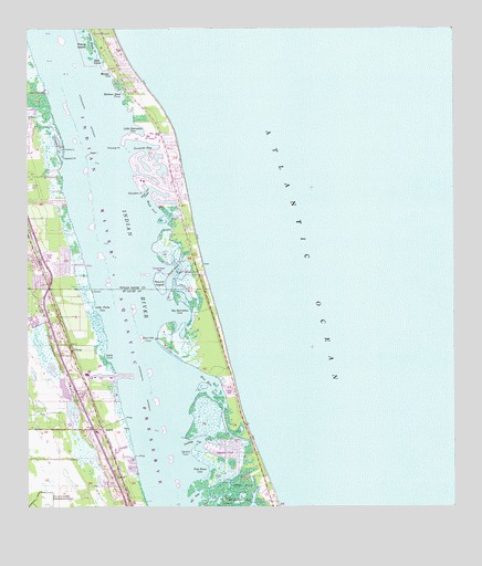
Indrio, FL USGS Topographic Map
Click on map above to begin viewing in our Map Viewer.

This topographic map contains these locations and features:
Feature Name Type Latitude Longitude GNIS ID View Map
Avalon State ParkParkN27.5514°W80.3208°1946051View Map
Barkers Ditch CoveBayN27.6078°W80.3471°278111View Map
Big Starvation CoveBayN27.5504°W80.3311°307888View Map
Blue Hole CreekBayN27.5328°W80.3211°307893View Map
Blue Hole PointCapeN27.5442°W80.3370°307894View Map
Country Cove Mobile Home CommunityPopulated PlaceN27.5067°W80.3510°2448174View Map
Crawford CreekBayN27.5944°W80.3657°281011View Map
Crawford PointCapeN27.5925°W80.3642°281017View Map
Cypress Bay Mobile Home ParkPopulated PlaceN27.5504°W80.3712°2448175View Map
Fernandina Beach Municipal Golf CourseLocaleN27.5044°W80.3579°2448158View Map
Fish House CoveBayN27.5099°W80.3248°307953View Map
Garfield CutBayN27.5174°W80.3257°307971View Map
Garfield PointCapeN27.5164°W80.3253°307972View Map
Head CoveBayN27.5783°W80.3375°283846View Map
Head Cove PocketBayN27.5827°W80.3397°283847View Map
Hells PocketBayN27.6166°W80.3529°283885View Map
Hillcrest Memorial GardensCemeteryN27.5481°W80.3678°2071788View Map
Indian River County Fire Rescue Station 6BuildingN27.6028°W80.3396°2644491View Map
IndrioPopulated PlaceN27.5206°W80.3528°307996View Map
Little Parks CoveBayN27.5521°W80.3549°308012View Map
Little Starvation CoveBayN27.5987°W80.3422°285830View Map
Martin CoveBayN27.6133°W80.3504°286470View Map
Midway Estates Mobile Home ParkPopulated PlaceN27.5661°W80.3682°2452620View Map
Negro CutBayN27.5013°W80.3227°308053View Map
North Hutchinson IslandIslandN27.5570°W80.3248°308378View Map
Old InletBayN27.5026°W80.3256°308060View Map
Parks CoveBayN27.5401°W80.3515°308072View Map
Pepper Beach State Recreation AreaParkN27.5045°W80.3145°308277View Map
Porpoise BayBayN27.5942°W80.3425°289221View Map
Porpoise PointCapeN27.5945°W80.3464°289229View Map
Prang IslandIslandN27.6220°W80.3570°289289View Map
Prang Island CreekBayN27.6229°W80.3563°289290View Map
Queens CovePopulated PlaceN27.5142°W80.3164°308199View Map
Round IslandBayN27.5628°W80.3337°289994View Map
Round IslandIslandN27.5586°W80.3359°289995View Map
Round Island ParkParkN27.5609°W80.3267°302699View Map
Saint Lucie PlazaLocaleN27.5198°W80.2920°308181View Map
Shell IslandIslandN27.5923°W80.3570°290974View Map
South BeachPopulated PlaceN27.5911°W80.3442°1867204View Map
South Beach Census Designated PlaceCensusN27.5883°W80.3435°2402867View Map
Starvation PointCapeN27.5828°W80.3409°291646View Map
Torpey Oaks Mobile Home ParkPopulated PlaceN27.5088°W80.3491°2448172View Map
VikingPopulated PlaceN27.5417°W80.3620°308163View Map
WAVW-FM (Vero Beach)TowerN27.5464°W80.3687°310274View Map
WCXL-FM (Vero Beach)TowerN27.5561°W80.3687°310273View Map

Note: Coordinates in the location and feature list above are referenced to NAD83 datum.


Copyright (C) 2008-2024 Ryan Niemi / Sunset Dynamics ... All Rights Reserved