TopoQuest Logo
Do you find TopoQuest useful?
Help keep TopoQuest running and adding new maps/features by donating!
Bitcoin:  19c7KJd3qBynnjoSw5npx9KScwjBe4ifkT
Litecoin:  LXs6TkuXGGXo1vDsWCkWVdjQX94eUKd6ui
Home View Maps Find Maps Find Places Resources & Links


Jacksonville East, Alabama Topographic Map

USGS Map Title: Jacksonville East, AL
USGS Map MRC: 33085G6
DRG (GeoTIFF) Download: o33085g6.tif


Neighboring USGS Topographic Map Quads:


  Colvin Gap, AL  
33085H7
 

  Piedmont NW, AL  
33085H6
 

  Piedmont, AL  
33085H5
 

  Jacksonville West, AL  
33085G7
 

  Jacksonville East, AL  
33085G6
 

  Piedmont SE, AL  
33085G5
 

  Anniston, AL  
33085F7
 

  Choccolocco, AL  
33085F6
 

  Heflin, AL  
33085F5


Map MRC Location:

N34°
W86°
N34°
W85°
H8 H7 H6 H5 H4 H3 H2 H1
G8 G7 G6 G5 G4 G3 G2 G1
F8 F7 F6 F5 F4 F3 F2 F1
E8 E7 E6 E5 E4 E3 E2 E1
D8 D7 D6 D5 D4 D3 D2 D1
C8 C7 C6 C5 C4 C3 C2 C1
B8 B7 B6 B5 B4 B3 B2 B1
A8 A7 A6 A5 A4 A3 A2 A1
N33°
W86°
N33°
W85°

Jacksonville East, AL USGS 1:24K Topographic Map Preview:
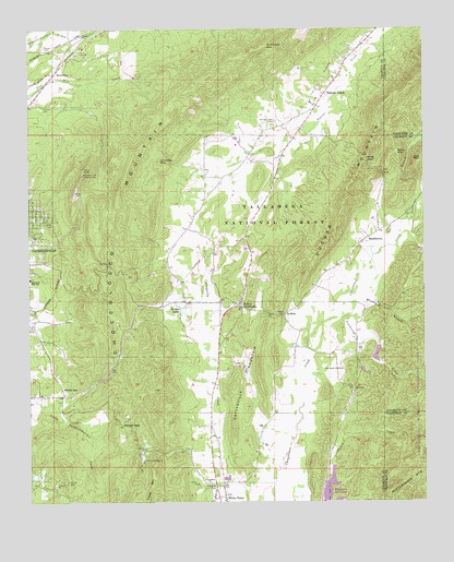
Jacksonville East, AL USGS Topographic Map
Click on map above to begin viewing in our Map Viewer.

This topographic map contains these locations and features:
Feature Name Type Latitude Longitude GNIS ID View Map
Arthur Wellborn School (historical)SchoolN33.7951°W85.6666°162136View Map
Ben White PointSummitN33.7798°W85.7108°162139View Map
Berry MountainSummitN33.8423°W85.6336°159152View Map
Boozer CemeteryCemeteryN33.8707°W85.7455°159233View Map
Browns SpringSpringN33.8112°W85.6586°162899View Map
Camp CottaquillaLocaleN33.7607°W85.7144°159298View Map
Carpenters BendBendN33.8618°W85.7422°162842View Map
Carpond SpringSpringN33.8018°W85.6397°162901View Map
Chimney MountainSummitN33.8404°W85.7094°159392View Map
Chimney PeakSummitN33.8370°W85.7330°162845View Map
Chimney Peak Lookout TowerTowerN33.8368°W85.7333°164305View Map
Choccolocco MountainRidgeN33.8220°W85.7230°159402View Map
Community CemeteryCemeteryN33.8687°W85.7319°162166View Map
Community Congregational Holiness ChurchChurchN33.8690°W85.7314°162167View Map
Coosa Fields (historical)LocaleN33.7529°W85.6847°162852View Map
Cottaquilla DamDamN33.7601°W85.7150°161462View Map
Cottaquilla MountainSummitN33.7804°W85.6855°159453View Map
Dugger MountainRidgeN33.8379°W85.6461°159535View Map
Easterwood SpringSpringN33.7798°W85.6477°162906View Map
Eastwood High SchoolSchoolN33.8093°W85.7494°159551View Map
Foster MountainSummitN33.7551°W85.7102°159620View Map
Friendship ChurchChurchN33.7551°W85.6927°159634View Map
Green CemeteryCemeteryN33.8686°W85.7319°2084417View Map
HallingworthPopulated PlaceN33.8365°W85.6930°164533View Map
Holley CrossroadsPopulated PlaceN33.8015°W85.6836°159789View Map
Holley Crossroads Missionary Baptist ChurchChurchN33.8023°W85.6852°162860View Map
HollingsworthPopulated PlaceN33.8251°W85.6977°162188View Map
Hollingsworth School (historical)SchoolN33.8273°W85.6964°162189View Map
Hurricane MountainSummitN33.8709°W85.6764°159834View Map
JenkinsPopulated PlaceN33.7995°W85.6700°159859View Map
Jones BranchStreamN33.8209°W85.6300°159867View Map
King GapGapN33.8407°W85.6433°159897View Map
Lake CottaquillaReservoirN33.7620°W85.7145°161463View Map
McCain CemeteryCemeteryN33.8548°W85.7455°160066View Map
McCains Chapel Methodist Church (historical)ChurchN33.8548°W85.7436°162866View Map
MerrelltonPopulated PlaceN33.8634°W85.7419°160086View Map
Murray BranchStreamN33.8026°W85.6472°160207View Map
Nances CreekPopulated PlaceN33.8579°W85.6569°160210View Map
Nances Creek CemeteryCemeteryN33.8507°W85.6730°160212View Map
Nances Creek Census Designated PlaceCensusN33.8588°W85.6733°2582690View Map
Nances Creek Missionary Baptist ChurchChurchN33.8459°W85.6769°162870View Map
Nances Creek School (historical)SchoolN33.8493°W85.6639°162871View Map
New Oak Grove Missionary Baptist ChurchChurchN33.7851°W85.6525°160269View Map
NEW-AM (Jacksonville)TowerN33.8151°W85.7414°161036View Map
RabbittownPopulated PlaceN33.8198°W85.6427°160463View Map
Rabbittown GapGapN33.7848°W85.7252°162226View Map
Rabbittown Missionary Baptist ChurchChurchN33.8143°W85.6486°162225View Map
Red MountainSummitN33.8409°W85.6255°160477View Map
Roberts SpringSpringN33.8404°W85.6755°162911View Map
Rock House BranchStreamN33.8179°W85.6361°162879View Map
Salem Presbyterian ChurchChurchN33.8734°W85.7333°160552View Map
Scarbrough CreekStreamN33.7987°W85.6508°160573View Map
Shelton DamDamN33.7996°W85.7003°161467View Map
Shelton LakesReservoirN33.8006°W85.7011°160595View Map
The NarrowsGapN33.7995°W85.6730°162233View Map
Watsons Field SpringSpringN33.8007°W85.6583°162915View Map
Watsons House SpringSpringN33.7976°W85.6672°162916View Map
Wellborn CemeteryCemeteryN33.8695°W85.7388°162883View Map
White Plains Census Designated PlaceCensusN33.7603°W85.6880°2582707View Map
White Plains Volunteer Fire Department Station 2 HeadquartersBuildingN33.8201°W85.6807°2683058View Map
Whites GapGapN33.7707°W85.7208°160836View Map
Whites GapPopulated PlaceN33.7784°W85.7394°160837View Map
Whites Gap Baptist ChurchChurchN33.7784°W85.7391°162238View Map
Whites Gap CemeteryCemeteryN33.7793°W85.7389°162239View Map
Whites Gap School (historical)SchoolN33.7779°W85.7402°162887View Map
Whites Gap SpringSpringN33.7773°W85.7389°162918View Map
Williamson-Little CemeteryCemeteryN33.7520°W85.6883°162888View Map

Note: Coordinates in the location and feature list above are referenced to NAD83 datum.


Copyright (C) 2008-2024 Ryan Niemi / Sunset Dynamics ... All Rights Reserved