TopoQuest Logo
Do you find TopoQuest useful?
Help keep TopoQuest running and adding new maps/features by donating!
Bitcoin:  19c7KJd3qBynnjoSw5npx9KScwjBe4ifkT
Litecoin:  LXs6TkuXGGXo1vDsWCkWVdjQX94eUKd6ui
Home View Maps Find Maps Find Places Resources & Links


Javelina Basin, New Mexico Topographic Map

USGS Map Title: Javelina Basin, NM
USGS Map MRC: 32103A3
DRG (GeoTIFF) Download: o32103a3.tif


Neighboring USGS Topographic Map Quads:


  Woodley Flat, NM  
32103B4
 

  Custer Mountain, NM  
32103B3
 

  Jal NW, NM  
32103B2
 

  Andrews Place, NM  
32103A4
 

  Javelina Basin, NM  
32103A3
 

  Jal, NM  
32103A2
 

  Brunson Ranch, TX  
31103H4
 

  Cheyenne Draw, TX  
31103H3
 

  Kermit NW, TX  
31103H2


Map MRC Location:

N33°
W104°
N33°
W103°
H8 H7 H6 H5 H4 H3 H2 H1
G8 G7 G6 G5 G4 G3 G2 G1
F8 F7 F6 F5 F4 F3 F2 F1
E8 E7 E6 E5 E4 E3 E2 E1
D8 D7 D6 D5 D4 D3 D2 D1
C8 C7 C6 C5 C4 C3 C2 C1
B8 B7 B6 B5 B4 B3 B2 B1
A8 A7 A6 A5 A4 A3 A2 A1
N32°
W104°
N32°
W103°

Javelina Basin, NM USGS 1:24K Topographic Map Preview:
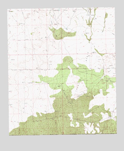
Javelina Basin, NM USGS Topographic Map
Click on map above to begin viewing in our Map Viewer.

This topographic map contains these locations and features:
Feature Name Type Latitude Longitude GNIS ID View Map
10117 Water WellWellN32.0460°W103.3477°931059View Map
11570 Water WellWellN32.0460°W103.3121°932184View Map
11571 Water WellWellN32.0476°W103.2621°931062View Map
11573 Water WellWellN32.0390°W103.3116°932182View Map
11574 Water WellWellN32.0387°W103.3116°932180View Map
11575 Water WellWellN32.0387°W103.3116°932181View Map
11576 Water WellWellN32.0273°W103.3038°931068View Map
11578 Water WellWellN32.0132°W103.2568°931064View Map
11604 Water WellWellN32.1210°W103.3257°932191View Map
11605 Water WellWellN32.1187°W103.3252°932190View Map
11606 Water WellWellN32.1171°W103.3735°931058View Map
11616 Water WellWellN32.0762°W103.2768°932189View Map
12958 Water WellWellN32.0440°W103.3143°932183View Map
12959 Water WellWellN32.0190°W103.3207°931067View Map
13634 Water WellWellN32.1226°W103.3705°932192View Map
Antelope DrawValleyN32.0885°W103.3138°885773View Map
Anthony RanchLocaleN32.0524°W103.2618°885814View Map
Beckham RanchLocaleN32.0151°W103.2968°886158View Map
Big WindmillLocaleN32.0996°W103.2843°886366View Map
Croft TankReservoirN32.1174°W103.2782°888082View Map
Dirt TankReservoirN32.1051°W103.3066°888400View Map
Fight in Hollow DrawValleyN32.0901°W103.2646°889026View Map
Hutchin WindmillLocaleN32.0171°W103.2566°890279View Map
Javelina BasinBasinN32.0604°W103.2863°923613View Map
Kammerer TanksReservoirN32.1226°W103.3138°890624View Map
Medlin PlacePopulated PlaceN32.1229°W103.3727°899763View Map
Natural TankReservoirN32.0518°W103.3474°892382View Map
New WindmillLocaleN32.0807°W103.2771°892509View Map
Pipeline WindmillLocaleN32.0485°W103.3149°893337View Map
Rock LakeLakeN32.0748°W103.3719°894060View Map
Tank WindmillLocaleN32.1212°W103.2971°895503View Map
West WindmillLocaleN32.0232°W103.3210°896443View Map

Note: Coordinates in the location and feature list above are referenced to NAD83 datum.


Copyright (C) 2008-2024 Ryan Niemi / Sunset Dynamics ... All Rights Reserved