TopoQuest Logo
Do you find TopoQuest useful?
Help keep TopoQuest running and adding new maps/features by donating!
Bitcoin:  19c7KJd3qBynnjoSw5npx9KScwjBe4ifkT
Litecoin:  LXs6TkuXGGXo1vDsWCkWVdjQX94eUKd6ui
Home View Maps Find Maps Find Places Resources & Links


Kilbourne, Illinois Topographic Map

USGS Map Title: Kilbourne, IL
USGS Map MRC: 40090B1
DRG (GeoTIFF) Download: o40090b1.tif


Neighboring USGS Topographic Map Quads:


  Duncan Mills, IL  
40090C2
 

  Havana, IL  
40090C1
 

  Topeka, IL  
40089C8
 

  Bath, IL  
40090B2
 

  Kilbourne, IL  
40090B1
 

  Biggs, IL  
40089B8
 

  Chandlerville, IL  
40090A2
 

  Newmansville, IL  
40090A1
 

  Oakford, IL  
40089A8


Map MRC Location:

N41°
W91°
N41°
W90°
H8 H7 H6 H5 H4 H3 H2 H1
G8 G7 G6 G5 G4 G3 G2 G1
F8 F7 F6 F5 F4 F3 F2 F1
E8 E7 E6 E5 E4 E3 E2 E1
D8 D7 D6 D5 D4 D3 D2 D1
C8 C7 C6 C5 C4 C3 C2 C1
B8 B7 B6 B5 B4 B3 B2 B1
A8 A7 A6 A5 A4 A3 A2 A1
N40°
W91°
N40°
W90°

Kilbourne, IL USGS 1:24K Topographic Map Preview:
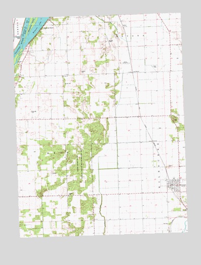
Kilbourne, IL USGS Topographic Map
Click on map above to begin viewing in our Map Viewer.

This topographic map contains these locations and features:
Feature Name Type Latitude Longitude GNIS ID View Map
ConoverPopulated PlaceN40.1773°W90.0240°422577View Map
Dierker LakeLakeN40.2468°W90.1056°1720357View Map
Frog Pond School (historical)SchoolN40.1562°W90.0496°408774View Map
Hardin School (historical)SchoolN40.1339°W90.0243°409769View Map
Havana Regional AirportAirportN40.2212°W90.0229°427363View Map
Johnson Landing Strip (historical)AirportN40.2217°W90.0418°1720361View Map
Jones CemeteryCemeteryN40.1892°W90.0057°1720362View Map
Jones School (historical)SchoolN40.1928°W90.0073°411224View Map
KelseyPopulated PlaceN40.2437°W90.0437°422865View Map
KilbournePopulated PlaceN40.1520°W90.0101°411459View Map
Kilbourne Baptist ChurchChurchN40.1514°W90.0134°1966332View Map
Kilbourne CemeteryCemeteryN40.1480°W90.0081°1964939View Map
Kilbourne CemeteryCemeteryN40.1478°W90.0087°1966346View Map
Kilbourne Fire DepartmentBuildingN40.1525°W90.0087°2640804View Map
Kilbourne Post OfficePost OfficeN40.1527°W90.0102°2788585View Map
LakewoodPopulated PlaceN40.2473°W90.0851°422893View Map
Long BranchPopulated PlaceN40.2173°W90.0379°422920View Map
Long Branch Sand Prairie Nature PreserveParkN40.2278°W90.0540°2009795View Map
Mason County State Wildlife Refuge and Recreation AreaParkN40.1667°W90.0793°1720366View Map
MatanzasPopulated PlaceN40.2312°W90.0996°422948View Map
Matanzas BeachPopulated PlaceN40.2431°W90.1040°413112View Map
Matanzas LakeLakeN40.2468°W90.1056°413115View Map
Matanzas Prairie Nature PreserveParkN40.2150°W90.1137°2009796View Map
Matanzas School (historical)SchoolN40.2312°W90.0993°1720368View Map
Mid-State DragwayLocaleN40.2353°W90.0546°1720371View Map
Mount Zion CemeteryCemeteryN40.1370°W90.0693°1966347View Map
Mount Zion CemeteryCemeteryN40.1367°W90.0693°1964885View Map
Mount Zion ChurchChurchN40.1370°W90.0696°414138View Map
Pratt CemeteryCemeteryN40.1300°W90.0148°1720376View Map
Saint Johns CemeteryCemeteryN40.2121°W90.0883°1966344View Map
Saint Johns ChurchChurchN40.2162°W90.0890°413113View Map
Sand Prairie - Scrub Oak Nature PreserveParkN40.1667°W90.0793°2009798View Map
Sedan Station (historical)LocaleN40.2323°W90.0404°1821496View Map
Township of BathCivilN40.1590°W90.1164°428641View Map
Village of KilbourneCivilN40.1519°W90.0115°2398343View Map
White Hall School (historical)SchoolN40.2023°W90.0896°421041View Map

Note: Coordinates in the location and feature list above are referenced to NAD83 datum.


Copyright (C) 2008-2024 Ryan Niemi / Sunset Dynamics ... All Rights Reserved