TopoQuest Logo
Do you find TopoQuest useful?
Help keep TopoQuest running and adding new maps/features by donating!
Bitcoin:  19c7KJd3qBynnjoSw5npx9KScwjBe4ifkT
Litecoin:  LXs6TkuXGGXo1vDsWCkWVdjQX94eUKd6ui
Home View Maps Find Maps Find Places Resources & Links


Kraemer, Louisiana Topographic Map

USGS Map Title: Kraemer, LA
USGS Map MRC: 29090G6
DRG (GeoTIFF) Download: o29090g6.tif


Neighboring USGS Topographic Map Quads:


  Lagan, LA  
29090H7
 

  Lower Vacherie, LA  
29090H6
 

  Lac des Allemands, LA  
29090H5
 

  Thibodaux, LA  
29090G7
 

  Kraemer, LA  
29090G6
 

  Bayou Boeuf, LA  
29090G5
 

  Gray, LA  
29090F7
 

  Savoie, LA  
29090F6
 

  Lockport, LA  
29090F5


Map MRC Location:

N30°
W91°
N30°
W90°
H8 H7 H6 H5 H4 H3 H2 H1
G8 G7 G6 G5 G4 G3 G2 G1
F8 F7 F6 F5 F4 F3 F2 F1
E8 E7 E6 E5 E4 E3 E2 E1
D8 D7 D6 D5 D4 D3 D2 D1
C8 C7 C6 C5 C4 C3 C2 C1
B8 B7 B6 B5 B4 B3 B2 B1
A8 A7 A6 A5 A4 A3 A2 A1
N29°
W91°
N29°
W90°

Kraemer, LA USGS 1:24K Topographic Map Preview:
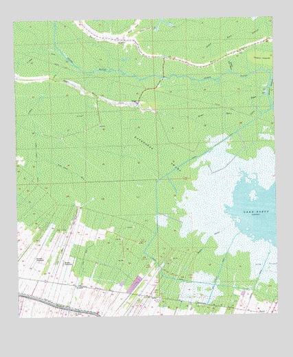
Kraemer, LA USGS Topographic Map
Click on map above to begin viewing in our Map Viewer.

This topographic map contains these locations and features:
Feature Name Type Latitude Longitude GNIS ID View Map
Bayou Baton PilonStreamN29.8360°W90.6276°532438View Map
Bayou BoeufStreamN29.7897°W90.6456°532463View Map
Bayou Jean WebreStreamN29.8524°W90.6451°532640View Map
Bayou PlatStreamN29.8433°W90.6287°532728View Map
ChoctawPopulated PlaceN29.8391°W90.6909°557805View Map
Choctaw Census Designated PlaceCensusN29.8457°W90.7234°2583533View Map
Choctaw School Gas FieldOilfieldN29.8213°W90.7215°557806View Map
Choctaw Volunteer Fire Department Station Number 1BuildingN29.8393°W90.7006°2691766View Map
EwingPopulated PlaceN29.7583°W90.6862°543194View Map
Grand BayouStreamN29.8497°W90.6262°560862View Map
Halpin CanalCanalN29.7963°W90.6829°535502View Map
KraemerPopulated PlaceN29.8669°W90.6970°536230View Map
Kraemer Census Designated PlaceCensusN29.8606°W90.6337°2583538View Map
La Peans CanalCanalN29.8294°W90.7490°536243View Map
Lafourche Parish Fire District 1 Station 4BuildingN29.7531°W90.7204°2691784View Map
Lafourche Parish Fire District 1 Station 7BuildingN29.7589°W90.7477°2691627View Map
Lafourche Parish Library Choctaw BranchBuildingN29.8513°W90.7389°2603098View Map
Laurel Valley CanalCanalN29.7977°W90.7426°536355View Map
Melodia Gas FieldOilfieldN29.7738°W90.6987°557848View Map
Melodia PlantationPopulated PlaceN29.7733°W90.7281°543464View Map
Northwest Lake Boeuf Oil and Gas FieldOilfieldN29.8133°W90.6476°557855View Map
Parish Governing Authority District 2CivilN29.8236°W90.7187°1929900View Map
Parish Governing Authority District 4CivilN29.7664°W90.7357°1930018View Map
Pitre Lening CanalCanalN29.8135°W90.7281°538224View Map
Rathborne SwampSwampN29.8180°W90.6801°538500View Map
RousseauPopulated PlaceN29.7635°W90.7226°541182View Map
Saint CharlesPopulated PlaceN29.7533°W90.7209°557871View Map
Saint Charles Borromeo Catholic ChurchChurchN29.7539°W90.7204°2602617View Map
Saint James ChapelChurchN29.8391°W90.6913°2602631View Map
Sam Foret CanalCanalN29.7672°W90.6537°539116View Map
Sixth Ward Middle SchoolSchoolN29.8511°W90.7396°553982View Map
Southwest Lake Boeuf Gas FieldOilfieldN29.7544°W90.6648°557886View Map
St Charles Elementary SchoolSchoolN29.7518°W90.7230°1629772View Map
TheriotPopulated PlaceN29.7505°W90.6320°543722View Map
Theriot CanalCanalN29.7616°W90.6365°539860View Map
Theriot FieldAirportN29.7537°W90.7342°2676745View Map
Walker PointFlatN29.8708°W90.6865°540201View Map
Ward SixCivilN29.8649°W90.7401°545098View Map
Webster PlantationLocaleN29.7749°W90.7415°540278View Map

Note: Coordinates in the location and feature list above are referenced to NAD83 datum.


Copyright (C) 2008-2024 Ryan Niemi / Sunset Dynamics ... All Rights Reserved