TopoQuest Logo
Do you find TopoQuest useful?
Help keep TopoQuest running and adding new maps/features by donating!
Bitcoin:  19c7KJd3qBynnjoSw5npx9KScwjBe4ifkT
Litecoin:  LXs6TkuXGGXo1vDsWCkWVdjQX94eUKd6ui
Home View Maps Find Maps Find Places Resources & Links


La Mesa, New Mexico Topographic Map

USGS Map Title: La Mesa, NM
USGS Map MRC: 32106A6
DRG (GeoTIFF) Download: o32106a6.tif


Neighboring USGS Topographic Map Quads:


  Black Mesa, NM  
32106B7
 

  San Miguel, NM  
32106B6
 

  Bishop Cap, NM  
32106B5
 

  Little Black Mountain, NM  
32106A7
 

  La Mesa, NM  
32106A6
 

  Anthony, NM  
32106A5
 

  Lanark, NM  
31106H7
 

  La Union, NM  
31106H6
 

  Canutillo, TX  
31106H5


Map MRC Location:

N33°
W107°
N33°
W106°
H8 H7 H6 H5 H4 H3 H2 H1
G8 G7 G6 G5 G4 G3 G2 G1
F8 F7 F6 F5 F4 F3 F2 F1
E8 E7 E6 E5 E4 E3 E2 E1
D8 D7 D6 D5 D4 D3 D2 D1
C8 C7 C6 C5 C4 C3 C2 C1
B8 B7 B6 B5 B4 B3 B2 B1
A8 A7 A6 A5 A4 A3 A2 A1
N32°
W107°
N32°
W106°

La Mesa, NM USGS 1:24K Topographic Map Preview:
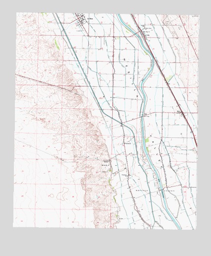
La Mesa, NM USGS Topographic Map
Click on map above to begin viewing in our Map Viewer.

This topographic map contains these locations and features:
Feature Name Type Latitude Longitude GNIS ID View Map
10058 Water WellWellN32.1115°W106.7056°919475View Map
10066 Water WellWellN32.0682°W106.6411°919473View Map
10121 Water WellWellN32.0115°W106.6630°919471View Map
10122 Water WellWellN32.0123°W106.6786°919472View Map
Anthony DrainCanalN32.0251°W106.6361°885812View Map
Apodaca Arroyo DamDamN32.1151°W106.7272°924061View Map
Berino BridgeBridgeN32.0657°W106.6633°928881View Map
Berino SidingLocaleN32.0670°W106.6358°886236View Map
Bern W 150 Water WellWellN32.0601°W106.6869°919371View Map
Big Sky DairyLocaleN32.1022°W106.6308°2710200View Map
Bosque School (historical)SchoolN32.0359°W106.6419°933968View Map
Bullock LateralCanalN32.0476°W106.6369°886913View Map
ChamberinoPopulated PlaceN32.0401°W106.6856°899577View Map
Chamberino Census Designated PlaceCensusN32.0364°W106.6776°2584072View Map
Chamberino DrainCanalN32.1023°W106.6794°897335View Map
Chamberino East LateralCanalN32.1048°W106.6689°887415View Map
Chamberino Post OfficePost OfficeN32.0498°W106.6753°938140View Map
Chamberino SchoolSchoolN32.0309°W106.6728°887417View Map
Chamberino Volunteer Fire DepartmentBuildingN32.0362°W106.6853°2657856View Map
Deck LateralCanalN32.0009°W106.6717°888258View Map
Desertland DairyLocaleN32.0919°W106.6353°2710195View Map
Dunbar SchoolSchoolN32.1182°W106.6628°888569View Map
El OjitoPopulated PlaceN32.0054°W106.6780°899623View Map
Hutchins WellWellN32.1248°W106.6278°890280View Map
J 2 Water WellWellN32.0065°W106.6783°919368View Map
J 3 Water WellWellN32.0040°W106.6680°919367View Map
Jiminez LateralCanalN32.0093°W106.6478°890465View Map
K 23 Water WellWellN32.0020°W106.6503°919439View Map
Kilgore LateralCanalN32.0623°W106.6414°890691View Map
La MesaPopulated PlaceN32.1220°W106.7078°899706View Map
La Mesa Baptist ChurchChurchN32.1220°W106.7078°921187View Map
La Mesa Census Designated PlaceCensusN32.1244°W106.7090°2584130View Map
La Mesa Elementary SchoolSchoolN32.1220°W106.7078°933921View Map
La Mesa Post OfficePost OfficeN32.1194°W106.7057°2781533View Map
La Mesa Post Office (historical)Post OfficeN32.1220°W106.7078°938413View Map
La Mesa United Methodist ChurchChurchN32.1220°W106.7078°920527View Map
La Mesa Volunteer Fire DepartmentBuildingN32.1220°W106.7080°2658130View Map
La Union Elementary SchoolSchoolN32.1220°W106.7078°933858View Map
La Union Main CanalCanalN32.0348°W106.6625°890842View Map
Liberty School (historical)SchoolN32.0887°W106.6831°933967View Map
LM-2 Water WellWellN32.0615°W106.6767°919372View Map
LM-5 Water WellWellN32.0679°W106.6303°919373View Map
LM-7 Water WellWellN32.0118°W106.6442°919431View Map
Lower Chamberino LateralCanalN32.0387°W106.6736°891423View Map
Nemexas DrainCanalN32.0059°W106.6564°892423View Map
New Hope ChurchChurchN32.1148°W106.6642°892438View Map
Pipeline BridgeBridgeN32.0665°W106.6631°929012View Map
Refugio Colony GrantCivilN32.0182°W106.6525°920672View Map
Rigney DrainCanalN32.0926°W106.6667°893898View Map
Saint Josephs CemeteryCemeteryN32.1151°W106.7050°894278View Map
San Jose Catholic Church Historic SiteChurchN32.1220°W106.7078°934357View Map
San Luis CemeteryCemeteryN32.0331°W106.6864°894458View Map
San Luis ChurchChurchN32.0368°W106.6858°894459View Map
Sunset DairyLocaleN32.0883°W106.6353°2710199View Map
Three Saints LateralCanalN32.0643°W106.6542°895654View Map
Three Saints West LateralCanalN32.0332°W106.6472°895655View Map
TW-5 Water WellWellN32.1043°W106.6931°919427View Map
United States Bureau of Reclamation 5 Water WellWellN32.1043°W106.6931°919426View Map
VadoPopulated PlaceN32.1118°W106.6625°920727View Map
Vado 1300 Water WellWellN32.0973°W106.6381°919425View Map
Vado Post Office (historical)Post OfficeN32.1118°W106.6625°937326View Map
Valley Grove Baptist ChurchChurchN32.1118°W106.6625°921035View Map
Valley Grove ChurchChurchN32.1170°W106.6631°896087View Map
W Resource Water WellWellN32.0962°W106.6844°919375View Map
Wood LateralCanalN32.0315°W106.6555°896744View Map

Note: Coordinates in the location and feature list above are referenced to NAD83 datum.


Copyright (C) 2008-2024 Ryan Niemi / Sunset Dynamics ... All Rights Reserved