TopoQuest Logo
Do you find TopoQuest useful?
Help keep TopoQuest running and adding new maps/features by donating!
Bitcoin:  19c7KJd3qBynnjoSw5npx9KScwjBe4ifkT
Litecoin:  LXs6TkuXGGXo1vDsWCkWVdjQX94eUKd6ui
Home View Maps Find Maps Find Places Resources & Links


Lake Boren, Oklahoma Topographic Map

USGS Map Title: Lake Boren, OK
USGS Map MRC: 35096G1
DRG (GeoTIFF) Download: o35096g1.tif


Neighboring USGS Topographic Map Quads:


  Kellyville, OK  
35096H2
 

  Sapulpa South, OK  
35096H1
 

  Bixby, OK  
35095H8
 

  Kiefer SW, OK  
35096G2
 

  Lake Boren, OK  
35096G1
 

  Spanish Peak, OK  
35095G8
 

  Nuyaka, OK  
35096F2
 

  Beggs, OK  
35096F1
 

  Okmulgee North, OK  
35095F8


Map MRC Location:

N36°
W97°
N36°
W96°
H8 H7 H6 H5 H4 H3 H2 H1
G8 G7 G6 G5 G4 G3 G2 G1
F8 F7 F6 F5 F4 F3 F2 F1
E8 E7 E6 E5 E4 E3 E2 E1
D8 D7 D6 D5 D4 D3 D2 D1
C8 C7 C6 C5 C4 C3 C2 C1
B8 B7 B6 B5 B4 B3 B2 B1
A8 A7 A6 A5 A4 A3 A2 A1
N35°
W97°
N35°
W96°

Lake Boren, OK USGS 1:24K Topographic Map Preview:
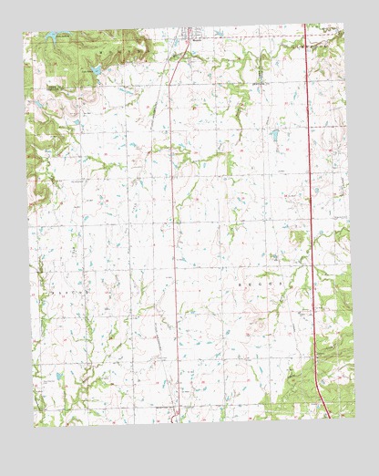
Lake Boren, OK USGS Topographic Map
Click on map above to begin viewing in our Map Viewer.

This topographic map contains these locations and features:
Feature Name Type Latitude Longitude GNIS ID View Map
Beggs DivisionCivilN35.7946°W96.0404°1937644View Map
Beggs Elementary SchoolSchoolN35.7531°W96.0827°1790556View Map
Beggs Middle SchoolSchoolN35.7519°W96.0827°1790260View Map
Eagle Creek AirportAirportN35.7944°W96.0325°2717019View Map
KGLB-TV (Okmulgee)TowerN35.8234°W96.1156°1102834View Map
KQMJ-FM (Henryetta)TowerN35.8340°W96.1247°1102802View Map
KTHK-FM (Okmulgee)TowerN35.8340°W96.1247°1102813View Map
Lake BorenReservoirN35.8622°W96.0968°1090407View Map
Lake Boren DamDamN35.8618°W96.0969°1758794View Map
Lake JacksonReservoirN35.8743°W96.1119°1758793View Map
Middle Duck CreekStreamN35.8712°W96.0011°1095353View Map
Mounds Fire Department Station 1 HeadquartersBuildingN35.8732°W96.0612°2656891View Map
New Bethel CemeteryCemeteryN35.8278°W96.1036°2709115View Map
New Bethel ChurchChurchN35.8273°W96.1033°1095794View Map
New Post Oak CemeteryCemeteryN35.7645°W96.1214°1095834View Map
North Duck CreekStreamN35.8712°W96.0011°1095938View Map
Oakdale CemeteryCemeteryN35.7704°W96.0147°1096135View Map
Oakwood CemeteryCemeteryN35.8645°W96.0578°1096165View Map
Oknoname 111012 DamDamN35.7651°W96.1153°1753497View Map
Oknoname 111012 ReservoirReservoirN35.7660°W96.1151°1753498View Map
Oknoname 111015 DamDamN35.8451°W96.1053°1752487View Map
Oknoname 111015 ReservoirReservoirN35.8461°W96.1051°1752488View Map
Oknoname 111016 DamDamN35.8518°W96.1186°1752489View Map
Oknoname 111016 ReservoirReservoirN35.8522°W96.1197°1752490View Map
Oknoname 111017 DamDamN35.8418°W96.0269°1751935View Map
Oknoname 111017 ReservoirReservoirN35.8404°W96.0282°1751936View Map
Ragwing Acres AirportAirportN35.8172°W96.0586°1102574View Map
South Duck CreekStreamN35.8632°W96.0394°1098228View Map
Town of MoundsCivilN35.8574°W96.0571°2413017View Map
Township of BeggsCivilN35.7918°W96.0364°1824883View Map

Note: Coordinates in the location and feature list above are referenced to NAD83 datum.


Copyright (C) 2008-2024 Ryan Niemi / Sunset Dynamics ... All Rights Reserved