TopoQuest Logo
Do you find TopoQuest useful?
Help keep TopoQuest running and adding new maps/features by donating!
Bitcoin:  19c7KJd3qBynnjoSw5npx9KScwjBe4ifkT
Litecoin:  LXs6TkuXGGXo1vDsWCkWVdjQX94eUKd6ui
Home View Maps Find Maps Find Places Resources & Links


Lake Poygan, Wisconsin Topographic Map

USGS Map Title: Lake Poygan, WI
USGS Map MRC: 44088B7
DRG (GeoTIFF) Download: o44088b7.tif


Neighboring USGS Topographic Map Quads:


  Weyauwega, WI  
44088C8
 

  Readfield, WI  
44088C7
 

  Hortonville, WI  
44088C6
 

  Poy Sippi, WI  
44088B8
 

  Lake Poygan, WI  
44088B7
 

  Oshkosh NW, WI  
44088B6
 

  Auroraville, WI  
44088A8
 

  Eureka, WI  
44088A7
 

  Omro, WI  
44088A6


Map MRC Location:

N45°
W89°
N45°
W88°
H8 H7 H6 H5 H4 H3 H2 H1
G8 G7 G6 G5 G4 G3 G2 G1
F8 F7 F6 F5 F4 F3 F2 F1
E8 E7 E6 E5 E4 E3 E2 E1
D8 D7 D6 D5 D4 D3 D2 D1
C8 C7 C6 C5 C4 C3 C2 C1
B8 B7 B6 B5 B4 B3 B2 B1
A8 A7 A6 A5 A4 A3 A2 A1
N44°
W89°
N44°
W88°

Lake Poygan, WI USGS 1:24K Topographic Map Preview:
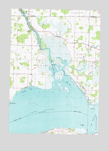
Lake Poygan, WI USGS Topographic Map
Click on map above to begin viewing in our Map Viewer.

This topographic map contains these locations and features:
Feature Name Type Latitude Longitude GNIS ID View Map
Alder CreekStreamN44.1719°W88.8454°1560738View Map
Becker CemeteryCemeteryN44.2253°W88.8168°1561483View Map
Boom BayBayN44.1761°W88.7934°1562061View Map
Boom IslandIslandN44.1983°W88.8187°1562062View Map
Boombay Volunteer Fire DepartmentBuildingN44.1840°W88.7917°2697792View Map
Clarks PointCapeN44.1528°W88.7590°1563124View Map
Engelwood FarmsLocaleN44.2006°W88.7531°2711718View Map
Hope ChurchChurchN44.2278°W88.8487°1566681View Map
Immanuel ChurchChurchN44.2194°W88.7865°1566876View Map
Lake PoyganLakeN44.1462°W88.8394°1571864View Map
Lone Willow IslandIslandN44.1341°W88.7701°1568518View Map
Norwegian BayBayN44.1683°W88.8501°1570551View Map
Old Indian PointCapeN44.1566°W88.8743°1570778View Map
OrihulaPopulated PlaceN44.2091°W88.8329°1570859View Map
Pages SloughBayN44.1878°W88.8137°1570992View Map
Poygan LakeLakeN44.1500°W88.7504°1577193View Map
Rat RiverStreamN44.1894°W88.8009°1572093View Map
Saint Pauls CemeteryCemeteryN44.2041°W88.8434°1573467View Map
Saint Peters CemeteryCemeteryN44.1769°W88.7809°1573523View Map
Saint Peters CemeteryCemeteryN44.1980°W88.7570°1964386View Map
Saint Peters ChurchChurchN44.1983°W88.7565°1573534View Map
Town of Wolf RiverCivilN44.1994°W88.8259°1584469View Map
Wolf River CemeteryCemeteryN44.2269°W88.8484°1576945View Map
Wolf River SchoolSchoolN44.1844°W88.8446°1576947View Map
Zion ChurchChurchN44.2436°W88.7746°1577159View Map
ZittauPopulated PlaceN44.2166°W88.7862°1577182View Map
Zittau CemeteryCemeteryN44.2197°W88.7865°1964393View Map

Note: Coordinates in the location and feature list above are referenced to NAD83 datum.


Copyright (C) 2008-2024 Ryan Niemi / Sunset Dynamics ... All Rights Reserved