TopoQuest Logo
Do you find TopoQuest useful?
Help keep TopoQuest running and adding new maps/features by donating!
Bitcoin:  19c7KJd3qBynnjoSw5npx9KScwjBe4ifkT
Litecoin:  LXs6TkuXGGXo1vDsWCkWVdjQX94eUKd6ui
Home View Maps Find Maps Find Places Resources & Links


Leesburg, South Carolina Topographic Map

USGS Map Title: Leesburg, SC
USGS Map MRC: 34080A6
DRG (GeoTIFF) Download: o34080a6.tif


Neighboring USGS Topographic Map Quads:


  Elgin, SC  
34080B7
 

  Lugoff, SC  
34080B6
 

  Camden South, SC  
34080B5
 

  Messers Pond, SC  
34080A7
 

  Leesburg, SC  
34080A6
 

  Rembert, SC  
34080A5
 

  Congaree, SC  
33080H7
 

  Eastover, SC  
33080H6
 

  Wedgefield, SC  
33080H5


Map MRC Location:

N35°
W81°
N35°
W80°
H8 H7 H6 H5 H4 H3 H2 H1
G8 G7 G6 G5 G4 G3 G2 G1
F8 F7 F6 F5 F4 F3 F2 F1
E8 E7 E6 E5 E4 E3 E2 E1
D8 D7 D6 D5 D4 D3 D2 D1
C8 C7 C6 C5 C4 C3 C2 C1
B8 B7 B6 B5 B4 B3 B2 B1
A8 A7 A6 A5 A4 A3 A2 A1
N34°
W81°
N34°
W80°

Leesburg, SC USGS 1:24K Topographic Map Preview:
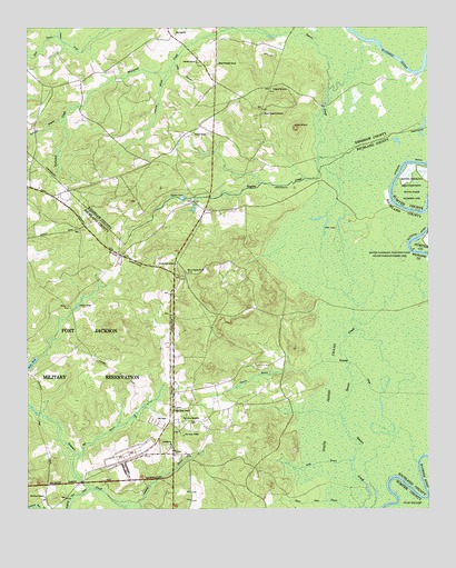
Leesburg, SC USGS Topographic Map
Click on map above to begin viewing in our Map Viewer.

This topographic map contains these locations and features:
Feature Name Type Latitude Longitude GNIS ID View Map
Beaver CreekPopulated PlaceN34.0835°W80.7262°1235335View Map
Bee BranchStreamN34.0143°W80.7348°1220456View Map
Burndown House (historical)BuildingN34.0515°W80.6812°1248974View Map
Cedar CreekPopulated PlaceN34.0760°W80.7187°1235348View Map
Chaver PondLakeN34.0528°W80.7342°1221526View Map
Colonels Creek Church (historical)ChurchN34.0529°W80.7426°1249013View Map
Concord ChurchChurchN34.1160°W80.6965°1247359View Map
Concord SchoolSchoolN34.0979°W80.6976°1221707View Map
Dabney Pond Church (historical)ChurchN34.0724°W80.7329°1249037View Map
Daley BranchStreamN34.1160°W80.7037°1221915View Map
Davis PondReservoirN34.0366°W80.7500°1221939View Map
Dobys Mill (historical)LocaleN34.1227°W80.6720°1235354View Map
Dunns MountSummitN34.0990°W80.6656°1247577View Map
English (historical)Populated PlaceN34.0779°W80.6945°1249074View Map
English PondLakeN34.0808°W80.7008°1222290View Map
English SwampSwampN34.0857°W80.6456°1235358View Map
Gafney Point SchoolSchoolN34.0635°W80.7090°1222622View Map
Jumping Run CreekStreamN34.0054°W80.7304°1223681View Map
LeesburgPopulated PlaceN34.0165°W80.7054°1231475View Map
Leesburg BranchStreamN34.0007°W80.7151°1223868View Map
Leesburg Fire Department Station 31BuildingN34.0089°W80.7041°2578864View Map
Leesburg School (historical)SchoolN34.0213°W80.7029°1249194View Map
Livingston Lodge (historical)BuildingN34.0057°W80.6437°1249203View Map
Madraw BranchStreamN34.0352°W80.6626°1224261View Map
McCaskillPopulated PlaceN34.1235°W80.7037°1231528View Map
McCaskill CreekStreamN34.1232°W80.6748°1246578View Map
Meadow ViewPopulated PlaceN34.1196°W80.7109°1235373View Map
Moke BranchStreamN34.0127°W80.6493°1224613View Map
Mount Pilgrim ChurchChurchN34.0615°W80.7004°1249641View Map
Mount Prospect CemeteryCemeteryN34.1026°W80.6765°1224789View Map
Mount Prospect ChurchChurchN34.1154°W80.6901°1249669View Map
Oak Grove ChurchChurchN34.0032°W80.7445°1249912View Map
Otter LakeLakeN34.0735°W80.6573°1225259View Map
Otterslide BranchStreamN34.1138°W80.7054°1225260View Map
Pigeon Roost BranchStreamN34.0004°W80.6462°1225417View Map
Pilgrim Church (historical)ChurchN34.0440°W80.7309°1249274View Map
Pine Grove CemeteryCemeteryN34.0232°W80.7017°1225435View Map
Pine Grove ChurchChurchN34.0263°W80.7040°1225442View Map
Pine Grove Church (historical)ChurchN34.0204°W80.7026°1249278View Map
Pine Grove SchoolSchoolN34.0193°W80.7012°1225450View Map
Progressive ChurchChurchN34.0668°W80.7218°1249287View Map
Prospect CemeteryCemeteryN34.1090°W80.6731°1225687View Map
Prospect Church (historical)ChurchN34.1102°W80.6734°1235381View Map
Raglins CreekStreamN34.0877°W80.6587°1250286View Map
Rununder BranchStreamN34.1013°W80.7381°1226074View Map
Scuffletown School (historical)SchoolN34.0718°W80.7329°1249344View Map
Shady Grove School (historical)SchoolN34.0663°W80.7206°1249348View Map
Sloan BranchStreamN34.1224°W80.7395°1226676View Map
Spears CreekPopulated PlaceN34.1163°W80.7218°1235389View Map
Spears CreekStreamN34.0004°W80.6462°1226784View Map
Texas School (historical)SchoolN34.0371°W80.7254°1249386View Map
White Marsh SwampSwampN34.0281°W80.6380°1227538View Map
Wilson Mill Pond D-0594 DamDamN34.0002°W80.7415°1237580View Map
WWDM-FM (Sumter)TowerN34.0513°W80.6818°1252552View Map
Zion Hill School (historical)SchoolN34.0571°W80.7298°1249438View Map

Note: Coordinates in the location and feature list above are referenced to NAD83 datum.


Copyright (C) 2008-2024 Ryan Niemi / Sunset Dynamics ... All Rights Reserved