TopoQuest Logo
Do you find TopoQuest useful?
Help keep TopoQuest running and adding new maps/features by donating!
Bitcoin:  19c7KJd3qBynnjoSw5npx9KScwjBe4ifkT
Litecoin:  LXs6TkuXGGXo1vDsWCkWVdjQX94eUKd6ui
Home View Maps Find Maps Find Places Resources & Links


Letona, Arkansas Topographic Map

USGS Map Title: Letona, AR
USGS Map MRC: 35091C7
DRG (GeoTIFF) Download: o35091c7.tif


Neighboring USGS Topographic Map Quads:


  West Pangburn, AR  
35091D8
 

  Pangburn, AR  
35091D7
 

  Steprock, AR  
35091D6
 

  Sidon, AR  
35091C8
 

  Letona, AR  
35091C7
 

  Judsonia, AR  
35091C6
 

  Floyd, AR  
35091B8
 

  Garner, AR  
35091B7
 

  Kensett, AR  
35091B6


Map MRC Location:

N36°
W92°
N36°
W91°
H8 H7 H6 H5 H4 H3 H2 H1
G8 G7 G6 G5 G4 G3 G2 G1
F8 F7 F6 F5 F4 F3 F2 F1
E8 E7 E6 E5 E4 E3 E2 E1
D8 D7 D6 D5 D4 D3 D2 D1
C8 C7 C6 C5 C4 C3 C2 C1
B8 B7 B6 B5 B4 B3 B2 B1
A8 A7 A6 A5 A4 A3 A2 A1
N35°
W92°
N35°
W91°

Letona, AR USGS 1:24K Topographic Map Preview:
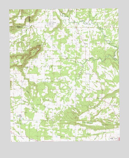
Letona, AR USGS Topographic Map
Click on map above to begin viewing in our Map Viewer.

This topographic map contains these locations and features:
Feature Name Type Latitude Longitude GNIS ID View Map
AlbionPopulated PlaceN35.3426°W91.7896°45802View Map
Albion Volunteer Fire DepartmentBuildingN35.3398°W91.7891°2116060View Map
Anders BranchStreamN35.3479°W91.8396°45861View Map
Assembly of God ChurchChurchN35.3134°W91.7826°45961View Map
Backbone RidgeRidgeN35.2656°W91.7743°46001View Map
Brier CreekStreamN35.3642°W91.7824°46951View Map
CrosbyPopulated PlaceN35.2820°W91.8335°81850View Map
Crosby Baptist ChurchChurchN35.2820°W91.8349°65054View Map
Foster ChapelChurchN35.2837°W91.7590°49193View Map
Fourmile HillPopulated PlaceN35.2906°W91.7704°76968View Map
Georgia RidgeRidgeN35.3256°W91.8693°49382View Map
Key BranchStreamN35.2568°W91.7740°50830View Map
LetonaPopulated PlaceN35.3617°W91.8293°81874View Map
Letona Missionary Baptist ChurchChurchN35.3612°W91.8279°65093View Map
Letona Volunteer Fire StationBuildingN35.3630°W91.8335°2116709View Map
Lick BranchStreamN35.3084°W91.7996°51128View Map
Little CreekStreamN35.3229°W91.7910°51243View Map
Low GapGapN35.3295°W91.8538°51488View Map
Morris InstituteSchoolN35.2748°W91.8635°52220View Map
Mount PisgahSummitN35.3342°W91.8463°53508View Map
Mount PisgahLocaleN35.3409°W91.8379°52373View Map
New Hope CemeteryCemeteryN35.2948°W91.7974°52663View Map
Otter PondLakeN35.3604°W91.7840°75065View Map
Owl CreekStreamN35.3629°W91.7807°53111View Map
Pan BranchStreamN35.2862°W91.8529°53142View Map
Panther CreekStreamN35.3270°W91.7549°53161View Map
PickensPopulated PlaceN35.3476°W91.8743°58362View Map
Saint Pauls CemeteryCemeteryN35.2779°W91.8599°54451View Map
Searcy High SchoolSchoolN35.2523°W91.7591°65110View Map
SmyrnaPopulated PlaceN35.2509°W91.8446°81637View Map
Smyrna ChurchChurchN35.2520°W91.8529°54970View Map
Town of LetonaCivilN35.3636°W91.8295°2406008View Map
Township of AlbionCivilN35.3410°W91.7978°69813View Map
Township of CrosbyCivilN35.2879°W91.8359°69824View Map
Township of GrayCivilN35.2655°W91.7734°69833View Map
Township of MarionCivilN35.3531°W91.8587°69846View Map
Township of Mount PisgahCivilN35.3205°W91.8501°69848View Map

Note: Coordinates in the location and feature list above are referenced to NAD83 datum.


Copyright (C) 2008-2024 Ryan Niemi / Sunset Dynamics ... All Rights Reserved