TopoQuest Logo
Do you find TopoQuest useful?
Help keep TopoQuest running and adding new maps/features by donating!
Bitcoin:  19c7KJd3qBynnjoSw5npx9KScwjBe4ifkT
Litecoin:  LXs6TkuXGGXo1vDsWCkWVdjQX94eUKd6ui
Home View Maps Find Maps Find Places Resources & Links


Lone Mountain, New Mexico Topographic Map

USGS Map Title: Lone Mountain, NM
USGS Map MRC: 33105G7
DRG (GeoTIFF) Download: o33105g7.tif


Neighboring USGS Topographic Map Quads:


  Dulce Draw, NM  
33105H8
 

  Little Black Peak NE, NM  
33105H7
 

  Ancho, NM  
33105H6


  Lone Mountain, NM  
33105G7
 

  White Oaks North, NM  
33105G6


  Carrizozo East, NM  
33105F7
 

  White Oaks South, NM  
33105F6


Map MRC Location:

N34°
W106°
N34°
W105°
H8 H7 H6 H5 H4 H3 H2 H1
G8 G7 G6 G5 G4 G3 G2 G1
F8 F7 F6 F5 F4 F3 F2 F1
E8 E7 E6 E5 E4 E3 E2 E1
D8 D7 D6 D5 D4 D3 D2 D1
C8 C7 C6 C5 C4 C3 C2 C1
B8 B7 B6 B5 B4 B3 B2 B1
A8 A7 A6 A5 A4 A3 A2 A1
N33°
W106°
N33°
W105°

Lone Mountain, NM USGS 1:24K Topographic Map Preview:
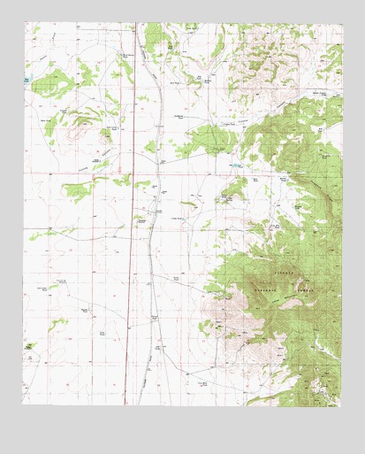
Lone Mountain, NM USGS Topographic Map
Click on map above to begin viewing in our Map Viewer.

This topographic map contains these locations and features:
Feature Name Type Latitude Longitude GNIS ID View Map
Ancho GulchValleyN33.8556°W105.8742°903149View Map
AsbestosMineN33.7987°W105.7630°916209View Map
Aviador MineMineN33.7529°W105.7572°939816View Map
Bentonite TankReservoirN33.8317°W105.7592°1985123View Map
Black Knight MineMineN33.7762°W105.7747°939820View Map
Blue TankReservoirN33.8553°W105.8144°1985112View Map
Bond Spring TankReservoirN33.8644°W105.8375°1985109View Map
Canyon TankReservoirN33.8418°W105.7982°1985118View Map
Carolyn OMineN33.7867°W105.7714°916948View Map
Cathy TankReservoirN33.8112°W105.8131°1985130View Map
Cindy MineMineN33.7990°W105.7572°939824View Map
ClaritaMineN33.8034°W105.7564°916949View Map
Click TankReservoirN33.7734°W105.8430°1985139View Map
Clipper MineMineN33.7642°W105.7636°916951View Map
Collier SpringSpringN33.8176°W105.7964°1985144View Map
Collier TankReservoirN33.8184°W105.7983°1985128View Map
Comstock MineMineN33.7576°W105.7642°939826View Map
CoyotePopulated PlaceN33.8126°W105.8236°905466View Map
Coyote WindmillLocaleN33.8298°W105.8455°1985121View Map
Doe TankReservoirN33.8662°W105.8175°1985108View Map
Dunning RanchLocaleN33.8340°W105.7980°1985142View Map
Eagle Nest Number One and TwoMineN33.7717°W105.7878°916240View Map
East TankReservoirN33.8245°W105.7861°1985125View Map
East WindmillLocaleN33.8517°W105.7519°1985114View Map
Empire MineMineN33.7529°W105.7572°939658View Map
FerroMineN33.7795°W105.8142°915296View Map
George TankReservoirN33.8151°W105.7700°1985131View Map
Goldfield MineMineN33.7529°W105.7572°939599View Map
Good Night MineMineN33.7762°W105.7747°939562View Map
Hannibal MineMineN33.7576°W105.7642°939566View Map
Hannibal Number 2 MineMineN33.7576°W105.7642°939567View Map
Harkey TankReservoirN33.8560°W105.8054°1985111View Map
He Horse MineMineN33.7529°W105.7572°939602View Map
Henry Clay MineMineN33.7626°W105.7603°915302View Map
Hogback RidgeRidgeN33.8206°W105.7583°1985127View Map
Iron CrownMineN33.7576°W105.7547°915310View Map
Iron Mine TankReservoirN33.7581°W105.8033°1985143View Map
Julia Ann ProspectMineN33.7651°W105.7894°915315View Map
Kelt TankReservoirN33.8404°W105.7584°1985119View Map
L M and M Incorporated MillMineN33.7648°W105.8078°914797View Map
Lady Godiva MineMineN33.7559°W105.7592°914798View Map
Large Hopes MineMineN33.7584°W105.7605°939486View Map
Lee TankReservoirN33.8287°W105.7925°1985122View Map
Little Homestake MineMineN33.7576°W105.7642°914802View Map
Little Mack MineMineN33.7623°W105.7603°914803View Map
Little Nell MineMineN33.7537°W105.7633°939578View Map
Lone MountainSummitN33.7840°W105.7767°923622View Map
Lone Mountain TankReservoirN33.8089°W105.7750°1985132View Map
May MineMineN33.7529°W105.7572°939488View Map
Mesa TankReservoirN33.8426°W105.8692°1985115View Map
Middle Pasture TankReservoirN33.8515°W105.7578°1985113View Map
Miguel Otero MineMineN33.7529°W105.7572°939579View Map
Miners CabinMineN33.7529°W105.7572°914811View Map
Murphy TankReservoirN33.8151°W105.7700°936622View Map
Norma Number 1 MineMineN33.7554°W105.7605°939491View Map
North Homestake MineMineN33.7554°W105.7605°914815View Map
North TankReservoirN33.7917°W105.8142°1985135View Map
Northern LightMineN33.7751°W105.7780°914816View Map
Northwest TankReservoirN33.8442°W105.8128°1985117View Map
Old Abe MineMineN33.7551°W105.7564°916964View Map
P C LymanMineN33.7651°W105.7611°916970View Map
Peakey TankReservoirN33.7684°W105.8719°1985140View Map
Peakey WindmillLocaleN33.7683°W105.8719°2088782View Map
Ponderosa WindmillLocaleN33.8101°W105.8308°1985129View Map
Post Corral TankReservoirN33.8405°W105.8387°1985120View Map
Red TankReservoirN33.8566°W105.8060°1985110View Map
Red TankReservoirN33.7687°W105.8216°1985141View Map
Riley Springs WindmillLocaleN33.7898°W105.8586°1985134View Map
Rip Van Winkle MineMineN33.7584°W105.7605°939803View Map
Rita MineMineN33.7556°W105.7605°916978View Map
Robert E Lee MineMineN33.7584°W105.7605°939958View Map
Round TankReservoirN33.8240°W105.7725°1985126View Map
Rustin TankReservoirN33.7812°W105.8498°1985136View Map
SacramentoMineN33.7709°W105.7930°916156View Map
Salt Cedar TankReservoirN33.7878°W105.8658°1985133View Map
Scranton MineMineN33.7537°W105.7633°939959View Map
Scraper TankReservoirN33.8459°W105.8586°1985116View Map
Shikeys Shyster ClaimMineN33.7537°W105.7633°916982View Map
Silver Cliff MineMineN33.7529°W105.7572°939960View Map
Smuggler MineMineN33.7537°W105.7639°916164View Map
Solitare MineMineN33.7529°W105.7572°939806View Map
South Homestake MineMineN33.7517°W105.7586°916166View Map
State MineMineN33.7856°W105.8047°914765View Map
SunshineMineN33.7709°W105.7705°916171View Map
Tunnel TankReservoirN33.7782°W105.8238°1985137View Map
Twin TankReservoirN33.8734°W105.8080°1985083View Map
Yellow JacketMineN33.7709°W105.7886°914775View Map

Note: Coordinates in the location and feature list above are referenced to NAD83 datum.


Copyright (C) 2008-2024 Ryan Niemi / Sunset Dynamics ... All Rights Reserved