TopoQuest Logo
Do you find TopoQuest useful?
Help keep TopoQuest running and adding new maps/features by donating!
Bitcoin:  19c7KJd3qBynnjoSw5npx9KScwjBe4ifkT
Litecoin:  LXs6TkuXGGXo1vDsWCkWVdjQX94eUKd6ui
Home View Maps Find Maps Find Places Resources & Links


Madewood, Louisiana Topographic Map

USGS Map Title: Madewood, LA
USGS Map MRC: 29090H8
DRG (GeoTIFF) Download: o29090h8.tif


Neighboring USGS Topographic Map Quads:


  Belle Rose, LA  
30091A1
 

  Donaldsonville, LA  
30090A8
 

  Convent, LA  
30090A7
 

  Napoleonville, LA  
29091H1
 

  Madewood, LA  
29090H8
 

  Lagan, LA  
29090H7
 

  Grassy Lake, LA  
29091G1
 

  Labadieville, LA  
29090G8
 

  Thibodaux, LA  
29090G7


Map MRC Location:

N30°
W91°
N30°
W90°
H8 H7 H6 H5 H4 H3 H2 H1
G8 G7 G6 G5 G4 G3 G2 G1
F8 F7 F6 F5 F4 F3 F2 F1
E8 E7 E6 E5 E4 E3 E2 E1
D8 D7 D6 D5 D4 D3 D2 D1
C8 C7 C6 C5 C4 C3 C2 C1
B8 B7 B6 B5 B4 B3 B2 B1
A8 A7 A6 A5 A4 A3 A2 A1
N29°
W91°
N29°
W90°

Madewood, LA USGS 1:24K Topographic Map Preview:
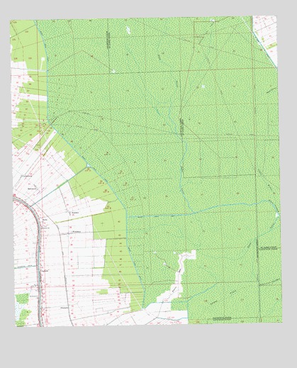
Madewood, LA USGS Topographic Map
Click on map above to begin viewing in our Map Viewer.

This topographic map contains these locations and features:
Feature Name Type Latitude Longitude GNIS ID View Map
AlbemarlePopulated PlaceN29.8827°W90.9748°542915View Map
Baker Canal EastCanalN29.9199°W90.9179°532283View Map
Baker Canal NorthCanalN29.9685°W90.9832°532284View Map
Baker Canal SouthCanalN29.9021°W90.9445°532285View Map
Bayou SecValleyN29.8789°W90.9318°532772View Map
BertiePopulated PlaceN29.9194°W90.9879°553608View Map
Burton Gas FieldOilfieldN29.9949°W90.9090°560301View Map
Cedar Grove Plantation PondReservoirN29.8785°W90.9234°556804View Map
Cedar Grove Plantation Pond DamDamN29.8785°W90.9234°556803View Map
Coteau FreneAreaN29.8858°W90.9020°534151View Map
Coteau Frene Oil and Gas FieldOilfieldN29.8960°W90.9273°552883View Map
Coulee MichelStreamN29.9233°W90.8782°560493View Map
Dons Flying Service Airport (historical)AirportN29.9308°W90.9887°1632865View Map
ElmfieldPopulated PlaceN29.9369°W90.9954°554356View Map
InglesidePopulated PlaceN29.8983°W90.9876°554832View Map
MadewoodPopulated PlaceN29.9321°W90.9895°543428View Map
Mount Carmel ChurchChurchN29.8869°W90.9893°537304View Map
Parish Governing Authority District 1CivilN29.9992°W90.9868°1929721View Map
Parish Governing Authority District 2CivilN29.8945°W90.9464°1929876View Map
RosedalePopulated PlaceN29.9216°W90.9737°555838View Map
Saint James CanalCanalN29.9933°W90.8859°1628115View Map
Ward TwoCivilN29.8874°W90.9509°544902View Map
West Burton Gas FieldOilfieldN29.9852°W90.9540°1629279View Map
WoodlawnPopulated PlaceN29.9133°W90.9743°556469View Map
Woodlawn ChurchChurchN29.9160°W90.9868°540524View Map

Note: Coordinates in the location and feature list above are referenced to NAD83 datum.


Copyright (C) 2008-2024 Ryan Niemi / Sunset Dynamics ... All Rights Reserved