TopoQuest Logo
Do you find TopoQuest useful?
Help keep TopoQuest running and adding new maps/features by donating!
Bitcoin:  19c7KJd3qBynnjoSw5npx9KScwjBe4ifkT
Litecoin:  LXs6TkuXGGXo1vDsWCkWVdjQX94eUKd6ui
Home View Maps Find Maps Find Places Resources & Links


Manchac, Louisiana Topographic Map

USGS Map Title: Manchac, LA
USGS Map MRC: 30090C4
DRG (GeoTIFF) Download: o30090c4.tif


Neighboring USGS Topographic Map Quads:


  Springfield, LA  
30090D5
 

  Ponchatoula, LA  
30090D4
 

  Ponchatoula NE, LA  
30090D3
 

  Killian, LA  
30090C5
 

  Manchac, LA  
30090C4
 

  Ponchatoula SE, LA  
30090C3
 

  Mount Airy NE, LA  
30090B5
 

  Ruddock, LA  
30090B4
 

  Bonnett Carre NE, LA  
30090B3


Map MRC Location:

N31°
W91°
N31°
W90°
H8 H7 H6 H5 H4 H3 H2 H1
G8 G7 G6 G5 G4 G3 G2 G1
F8 F7 F6 F5 F4 F3 F2 F1
E8 E7 E6 E5 E4 E3 E2 E1
D8 D7 D6 D5 D4 D3 D2 D1
C8 C7 C6 C5 C4 C3 C2 C1
B8 B7 B6 B5 B4 B3 B2 B1
A8 A7 A6 A5 A4 A3 A2 A1
N30°
W91°
N30°
W90°

Manchac, LA USGS 1:24K Topographic Map Preview:
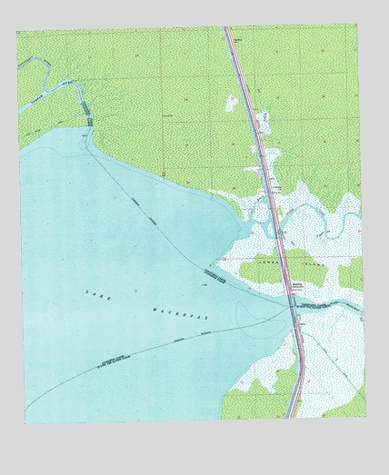
Manchac, LA USGS Topographic Map
Click on map above to begin viewing in our Map Viewer.

This topographic map contains these locations and features:
Feature Name Type Latitude Longitude GNIS ID View Map
AkersPopulated PlaceN30.2902°W90.4018°540636View Map
Akers Post OfficePost OfficeN30.2910°W90.4020°1631282View Map
Fernwood CanalCanalN30.3066°W90.4026°534936View Map
GalvaPopulated PlaceN30.2799°W90.3990°560811View Map
Galva CanalCanalN30.2613°W90.3804°560812View Map
Jim Reed BayouStreamN30.3169°W90.3751°536046View Map
Jones IslandIslandN30.2985°W90.3798°536109View Map
Joyce Wildlife Management AreaParkN30.3669°W90.3826°549691View Map
ManchacPopulated PlaceN30.2916°W90.4020°543439View Map
Manchac Baptist ChurchChurchN30.2916°W90.4018°549709View Map
Manchac Volunteer Fire DepartmentBuildingN30.2912°W90.4028°2691688View Map
Natalbany RiverStreamN30.3560°W90.4898°1627750View Map
North PassPopulated PlaceN30.3074°W90.4048°549727View Map
Owl BayouStreamN30.3133°W90.4159°537924View Map
Parish Governing Authority District 10CivilN30.3706°W90.4592°1929790View Map
Port ManchacLocaleN30.3155°W90.4056°540674View Map
SharkeyPopulated PlaceN30.3702°W90.4206°541189View Map
StraderPopulated PlaceN30.3235°W90.4076°543706View Map
T BayouStreamN30.3091°W90.3887°539778View Map
Tickfaw RiverStreamN30.3433°W90.4743°1628363View Map

Note: Coordinates in the location and feature list above are referenced to NAD83 datum.


Copyright (C) 2008-2024 Ryan Niemi / Sunset Dynamics ... All Rights Reserved