TopoQuest Logo
Do you find TopoQuest useful?
Help keep TopoQuest running and adding new maps/features by donating!
Bitcoin:  19c7KJd3qBynnjoSw5npx9KScwjBe4ifkT
Litecoin:  LXs6TkuXGGXo1vDsWCkWVdjQX94eUKd6ui
Home View Maps Find Maps Find Places Resources & Links


Manila, Utah Topographic Map

USGS Map Title: Manila, UT
USGS Map MRC: 40109H6
DRG (GeoTIFF) Download: o40109h6.tif


Neighboring USGS Topographic Map Quads:


  Antelope Wash, WY  
41109A7
 

  Linwood Canyon, WY  
41109A6
 

  Haystack Buttes South, WY  
41109A5
 

  Jessen Butte, UT  
40109H7
 

  Manila, UT  
40109H6
 

  Flaming Gorge, UT  
40109H5
 

  Leidy Peak, UT  
40109G7
 

  Elk Park, UT  
40109G6
 

  East Park Reservoir, UT  
40109G5


Map MRC Location:

N41°
W110°
N41°
W109°
H8 H7 H6 H5 H4 H3 H2 H1
G8 G7 G6 G5 G4 G3 G2 G1
F8 F7 F6 F5 F4 F3 F2 F1
E8 E7 E6 E5 E4 E3 E2 E1
D8 D7 D6 D5 D4 D3 D2 D1
C8 C7 C6 C5 C4 C3 C2 C1
B8 B7 B6 B5 B4 B3 B2 B1
A8 A7 A6 A5 A4 A3 A2 A1
N40°
W110°
N40°
W109°

Manila, UT USGS 1:24K Topographic Map Preview:
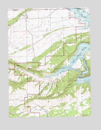
Manila, UT USGS Topographic Map
Click on map above to begin viewing in our Map Viewer.

This topographic map contains these locations and features:
Feature Name Type Latitude Longitude GNIS ID View Map
Beehive PointCapeN40.9194°W109.6415°1448123View Map
Birch Spring DrawValleyN40.9866°W109.6604°1438812View Map
Carmel CampgroundLocaleN40.9319°W109.7351°1439482View Map
Daggett County Ambulance ServiceBuildingN40.9885°W109.7199°2665456View Map
Death Valley CreekStreamN40.9255°W109.7101°1440332View Map
Death Valley EnclosureLocaleN40.8983°W109.7254°1450137View Map
Dowd MountainSummitN40.8875°W109.6679°1440537View Map
Dowd Mountain EnclosureLocaleN40.8836°W109.6693°1450140View Map
Dowd Mountain Overlook Picnic AreaLocaleN40.8966°W109.6254°1440538View Map
Dowd SpringSpringN40.8813°W109.6928°1440539View Map
Dowd Spring Recreation AreaLocaleN40.8819°W109.6932°1450139View Map
Dowds HoleLakeN40.8835°W109.7077°1440540View Map
Dowds Hole EnclosureLocaleN40.8850°W109.7079°1450138View Map
Flamingo Gorge OverlookLocaleN40.9075°W109.6988°1450145View Map
Henrys ForkStreamN40.9986°W109.6529°1454333View Map
Henrys ForkStreamN41.0000°W109.6576°1605136View Map
Hideout Boat CampLocaleN40.9152°W109.6474°1450141View Map
Hideout Canyon CampgroundLocaleN40.9116°W109.6410°1448470View Map
Hideout DrawValleyN40.9113°W109.6510°1441750View Map
Hideout Eagle Basin TrailLocaleN40.9022°W109.6485°1450142View Map
Kingfisher CanyonValleyN40.9252°W109.6318°1442327View Map
Kingfisher CreekStreamN40.9250°W109.6340°1455357View Map
Kingfisher IslandIslandN40.9330°W109.6418°1454784View Map
Kingfisher Island CampgroundLocaleN40.9405°W109.6418°1454785View Map
Linwood (historical)LocaleN40.9936°W109.6476°1448598View Map
ManilaPopulated PlaceN40.9880°W109.7226°1443126View Map
Manila AirportAirportN40.9873°W109.6757°1447611View Map
Manila CemeteryCemeteryN40.9969°W109.7151°1448637View Map
Manila Elementary SchoolSchoolN40.9915°W109.7259°1448640View Map
Manila High SchoolSchoolN40.9924°W109.7258°1448638View Map
Manila Post OfficePost OfficeN40.9917°W109.7220°2769070View Map
Manila Ranger StationLocaleN40.9880°W109.7254°1448639View Map
Manila Volunteer Fire DepartmentBuildingN40.9885°W109.7200°2627198View Map
Mann CampLocaleN40.9247°W109.7079°1450144View Map
Moenkopi CampgroundLocaleN40.9338°W109.7382°1443537View Map
Navajo Cliffs Picnic AreaParkN40.9283°W109.7235°1454833View Map
Peoples CanalCanalN40.9777°W109.6810°1444284View Map
Peoples CanalCanalN40.9997°W109.6818°1597667View Map
Sheep CreekStreamN40.9216°W109.6957°1445492View Map
Sheep Creek BayBayN40.9255°W109.6771°1454890View Map
Sheep Creek Bay CampgroundLocaleN40.9219°W109.6751°1454891View Map
Sheep Creek CanalCanalN40.9997°W109.7074°1584671View Map
Sheep Creek GapGapN40.9308°W109.7210°1445497View Map
South ValleyValleyN40.9752°W109.6451°1454907View Map
Spring CreekStreamN40.9325°W109.6832°1446024View Map
Summit SpringsSpringN40.8791°W109.7449°1446245View Map
Summit Springs Guard StationLocaleN40.8783°W109.7451°1454918View Map
The Church of Jesus Christ of Latter Day SaintsChurchN40.9902°W109.7249°1449535View Map
The ReavesRidgeN40.9597°W109.6685°1454870View Map
Town of ManilaCivilN40.9922°W109.7210°2412942View Map
United States Forest Service Fire Station - Manila OfficeBuildingN40.9876°W109.7237°2768445View Map
West Daggett DivisionCivilN40.8920°W109.7358°1939434View Map
Willow CampLocaleN40.9261°W109.7146°1450143View Map

Note: Coordinates in the location and feature list above are referenced to NAD83 datum.


Copyright (C) 2008-2024 Ryan Niemi / Sunset Dynamics ... All Rights Reserved