TopoQuest Logo
Do you find TopoQuest useful?
Help keep TopoQuest running and adding new maps/features by donating!
Bitcoin:  19c7KJd3qBynnjoSw5npx9KScwjBe4ifkT
Litecoin:  LXs6TkuXGGXo1vDsWCkWVdjQX94eUKd6ui
Home View Maps Find Maps Find Places Resources & Links


Marseilles, Ohio Topographic Map

USGS Map Title: Marseilles, OH
USGS Map MRC: 40083F4
DRG (GeoTIFF) Download: o40083f4.tif


Neighboring USGS Topographic Map Quads:


  Forest, OH  
40083G5
 

  Wharton, OH  
40083G4
 

  Upper Sandusky, OH  
40083G3
 

  Kenton, OH  
40083F5
 

  Marseilles, OH  
40083F4
 

  Meeker, OH  
40083F3
 

  Mount Victory, OH  
40083E5
 

  La Rue, OH  
40083E4
 

  New Bloomington, OH  
40083E3


Map MRC Location:

N41°
W84°
N41°
W83°
H8 H7 H6 H5 H4 H3 H2 H1
G8 G7 G6 G5 G4 G3 G2 G1
F8 F7 F6 F5 F4 F3 F2 F1
E8 E7 E6 E5 E4 E3 E2 E1
D8 D7 D6 D5 D4 D3 D2 D1
C8 C7 C6 C5 C4 C3 C2 C1
B8 B7 B6 B5 B4 B3 B2 B1
A8 A7 A6 A5 A4 A3 A2 A1
N40°
W84°
N40°
W83°

Marseilles, OH USGS 1:24K Topographic Map Preview:
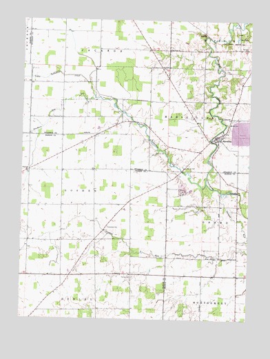
Marseilles, OH USGS Topographic Map
Click on map above to begin viewing in our Map Viewer.

This topographic map contains these locations and features:
Feature Name Type Latitude Longitude GNIS ID View Map
Bradley CemeteryCemeteryN40.7376°W83.4025°1730697View Map
Bryant School (historical)SchoolN40.6770°W83.4346°1055404View Map
Bud LakeLakeN40.7432°W83.3822°1038490View Map
Chandler CemeteryCemeteryN40.7070°W83.3863°1038979View Map
Coo School (historical)SchoolN40.7162°W83.4108°1055328View Map
Corey DairyLocaleN40.7431°W83.4647°2634674View Map
Fehl CemeteryCemeteryN40.6907°W83.3956°1040405View Map
Georgetown School (historical)SchoolN40.6870°W83.4605°1055422View Map
Goodhope CemeteryCemeteryN40.7095°W83.4827°1040950View Map
Hastings CemeteryCemeteryN40.6426°W83.4391°1041392View Map
Heckathorn School (historical)SchoolN40.7078°W83.4399°1055331View Map
Heilman AirportAirportN40.6705°W83.4438°1082766View Map
Hopewell ChurchChurchN40.6867°W83.4974°1041782View Map
Killdeer Upground ReservoirReservoirN40.7034°W83.3786°1078744View Map
Killdeer Upground Reservoir DamDamN40.7001°W83.3799°1078743View Map
Little Sandusky Post Office (historical)Post OfficeN40.7389°W83.4180°1958826View Map
Little Tymochtee CreekStreamN40.6820°W83.3980°1057802View Map
Mapletop School (historical)SchoolN40.7445°W83.4869°1055333View Map
MarseillesPopulated PlaceN40.7014°W83.3927°1061474View Map
Marseilles Elementary SchoolSchoolN40.7003°W83.3913°1055329View Map
Marseilles Post Office (historical)Post OfficeN40.7014°W83.3930°1958823View Map
Marseilles United Methodist ChurchChurchN40.7001°W83.3921°1073226View Map
Marseilles Volunteer Fire DepartmentBuildingN40.6985°W83.3915°2550433View Map
McKendree CemeteryCemeteryN40.6637°W83.4516°1043119View Map
McWiggin School (historical)SchoolN40.6578°W83.4594°1055448View Map
Noyes School (historical)SchoolN40.6320°W83.3810°1049610View Map
Oak Grove School (historical)SchoolN40.6289°W83.4002°1049609View Map
Paw Paw Freewill Baptist Church (historical)ChurchN40.6509°W83.3805°1071764View Map
Pawpaw CemeteryCemeteryN40.6509°W83.3811°1044334View Map
Pawpaw RunStreamN40.6795°W83.3952°1057915View Map
Pawpaw School (historical)SchoolN40.6728°W83.3808°1049611View Map
Pfeiffer School (historical)SchoolN40.6578°W83.4946°1055457View Map
Pisgah School (historical)SchoolN40.6267°W83.4919°1055458View Map
Reevhorn RunStreamN40.7173°W83.4594°1044922View Map
Ridgeway School (historical)SchoolN40.6506°W83.4196°1049612View Map
Salem CemeteryCemeteryN40.7439°W83.3996°1700973View Map
Salem ChurchChurchN40.7445°W83.3991°1045893View Map
Salem School (historical)SchoolN40.7445°W83.4002°1055327View Map
Schriver CemeteryCemeteryN40.6945°W83.4264°1046020View Map
Shanks CemeteryCemeteryN40.7020°W83.4921°1730729View Map
Stansbery CemeteryCemeteryN40.7282°W83.3752°1046635View Map
Terry Hill CemeteryCemeteryN40.6886°W83.4099°1046993View Map
Thomas CemeteryCemeteryN40.7143°W83.4202°1730734View Map
Township of GoshenCivilN40.6785°W83.4867°1086260View Map
Township of MarseillesCivilN40.7094°W83.3826°1087207View Map
Tri-County QuarryMineN40.6808°W83.4142°2567607View Map
Tymochtee School (historical)SchoolN40.7237°W83.4774°1055332View Map
Van Dongen DairyLocaleN40.6953°W83.4125°2703624View Map
Village of MarseillesCivilN40.7010°W83.3923°2399262View Map
Ward School (historical)SchoolN40.6295°W83.4383°1055486View Map
York Street CemeteryCemeteryN40.7303°W83.4231°1048207View Map
York Street ChurchChurchN40.7378°W83.4180°1058154View Map
York Street School (historical)SchoolN40.7376°W83.4316°1055330View Map

Note: Coordinates in the location and feature list above are referenced to NAD83 datum.


Copyright (C) 2008-2024 Ryan Niemi / Sunset Dynamics ... All Rights Reserved