TopoQuest Logo
Do you find TopoQuest useful?
Help keep TopoQuest running and adding new maps/features by donating!
Bitcoin:  19c7KJd3qBynnjoSw5npx9KScwjBe4ifkT
Litecoin:  LXs6TkuXGGXo1vDsWCkWVdjQX94eUKd6ui
Home View Maps Find Maps Find Places Resources & Links


McArthur, Ohio Topographic Map

USGS Map Title: McArthur, OH
USGS Map MRC: 39082B4
DRG (GeoTIFF) Download: o39082b4.tif


Neighboring USGS Topographic Map Quads:


  Allensville, OH  
39082C5
 

  Zaleski, OH  
39082C4
 

  Mineral, OH  
39082C3
 

  Hamden, OH  
39082B5
 

  McArthur, OH  
39082B4
 

  Vales Mills, OH  
39082B3
 

  Wellston, OH  
39082A5
 

  Mulga, OH  
39082A4
 

  Wilkesville, OH  
39082A3


Map MRC Location:

N40°
W83°
N40°
W82°
H8 H7 H6 H5 H4 H3 H2 H1
G8 G7 G6 G5 G4 G3 G2 G1
F8 F7 F6 F5 F4 F3 F2 F1
E8 E7 E6 E5 E4 E3 E2 E1
D8 D7 D6 D5 D4 D3 D2 D1
C8 C7 C6 C5 C4 C3 C2 C1
B8 B7 B6 B5 B4 B3 B2 B1
A8 A7 A6 A5 A4 A3 A2 A1
N39°
W83°
N39°
W82°

McArthur, OH USGS 1:24K Topographic Map Preview:
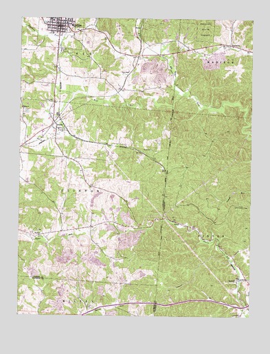
McArthur, OH USGS Topographic Map
Click on map above to begin viewing in our Map Viewer.

This topographic map contains these locations and features:
Feature Name Type Latitude Longitude GNIS ID View Map
Axtel School (historical)SchoolN39.1879°W82.3946°1051902View Map
Beard CemeteryCemeteryN39.1951°W82.4290°1037729View Map
Beech Hollow Sanitary LandfillLocaleN39.1333°W82.4711°2677592View Map
DundasPopulated PlaceN39.2037°W82.4802°1064565View Map
Dundas Fire DepartmentBuildingN39.2011°W82.4843°2549562View Map
Eagle Furnace (historical)LocaleN39.1751°W82.4207°1062146View Map
First Christian ChurchChurchN39.2478°W82.4765°1069991View Map
Haburn School (historical)SchoolN39.1495°W82.4485°1051916View Map
Haggerty School (historical)SchoolN39.1315°W82.4082°1051917View Map
Herbert Wescoat Memorial LibraryBuildingN39.2465°W82.4799°1807476View Map
Hilltop ChurchChurchN39.2123°W82.4988°1041604View Map
Hixon CemeteryCemeteryN39.2151°W82.4821°1041628View Map
Lincoln CemeteryCemeteryN39.1284°W82.4613°1042576View Map
Lincoln School (historical)SchoolN39.1298°W82.4474°1049588View Map
Mc Arthur Fire DepartmentBuildingN39.2482°W82.4813°2549811View Map
McArthurPopulated PlaceN39.2465°W82.4785°1076353View Map
McArthur Police DepartmentBuildingN39.2464°W82.4792°2732893View Map
McArthur United Methodist ChurchChurchN39.2453°W82.4788°1807477View Map
Old McArthur CemeteryCemeteryN39.2459°W82.4757°1961650View Map
OretonPopulated PlaceN39.1640°W82.4127°1062925View Map
Oreton Lookout TowerTowerN39.1712°W82.3813°1080160View Map
PrattsvillePopulated PlaceN39.2387°W82.3913°1061571View Map
Prattsville CemeteryCemeteryN39.2381°W82.3901°1961654View Map
Puncheon ForkStreamN39.2465°W82.4602°1076695View Map
PuritanPopulated PlaceN39.1587°W82.4890°1062958View Map
Puritan CemeteryCemeteryN39.1603°W82.4896°1961655View Map
Puritan Freewill Baptist ChurchChurchN39.1587°W82.4890°1071667View Map
RadcliffPopulated PlaceN39.1409°W82.3768°1061580View Map
Tar Farm School (historical)SchoolN39.1770°W82.4485°1082407View Map
Township of ClintonCivilN39.1775°W82.4788°1087100View Map
Trinity Episcopal ChurchChurchN39.2478°W82.4804°1069992View Map
Village of McArthurCivilN39.2466°W82.4787°2399283View Map
VintonPopulated PlaceN39.2442°W82.4368°1063079View Map
Vinton ChapelChurchN39.2278°W82.4404°1047464View Map
Vinton County Consolidated High SchoolSchoolN39.2490°W82.4824°1051932View Map
Vinton County Sheriff's OfficeBuildingN39.2463°W82.4788°2732950View Map
Vinton Furnace (historical)LocaleN39.2184°W82.4077°1051933View Map
Wolf RunStreamN39.2176°W82.4124°1067066View Map
WXMF-FM (McArthur)TowerN39.2470°W82.4693°1085381View Map
Zion CemeteryCemeteryN39.1792°W82.4593°1048250View Map

Note: Coordinates in the location and feature list above are referenced to NAD83 datum.


Copyright (C) 2008-2024 Ryan Niemi / Sunset Dynamics ... All Rights Reserved