TopoQuest Logo
Do you find TopoQuest useful?
Help keep TopoQuest running and adding new maps/features by donating!
Bitcoin:  19c7KJd3qBynnjoSw5npx9KScwjBe4ifkT
Litecoin:  LXs6TkuXGGXo1vDsWCkWVdjQX94eUKd6ui
Home View Maps Find Maps Find Places Resources & Links


Middletown, Maryland Topographic Map

USGS Map Title: Middletown, MD
USGS Map MRC: 39077D5
DRG (GeoTIFF) Download: o39077d5.tif


Neighboring USGS Topographic Map Quads:


  Funkstown, MD  
39077E6
 

  Myersville, MD  
39077E5
 

  Catoctin Furnace, MD  
39077E4
 

  Keedysville, MD  
39077D6
 

  Middletown, MD  
39077D5
 

  Frederick, MD  
39077D4
 

  Harpers Ferry, WV  
39077C6
 

  Point of Rocks, MD  
39077C5
 

  Buckeystown, MD  
39077C4


Map MRC Location:

N40°
W78°
N40°
W77°
H8 H7 H6 H5 H4 H3 H2 H1
G8 G7 G6 G5 G4 G3 G2 G1
F8 F7 F6 F5 F4 F3 F2 F1
E8 E7 E6 E5 E4 E3 E2 E1
D8 D7 D6 D5 D4 D3 D2 D1
C8 C7 C6 C5 C4 C3 C2 C1
B8 B7 B6 B5 B4 B3 B2 B1
A8 A7 A6 A5 A4 A3 A2 A1
N39°
W78°
N39°
W77°

Middletown, MD USGS 1:24K Topographic Map Preview:
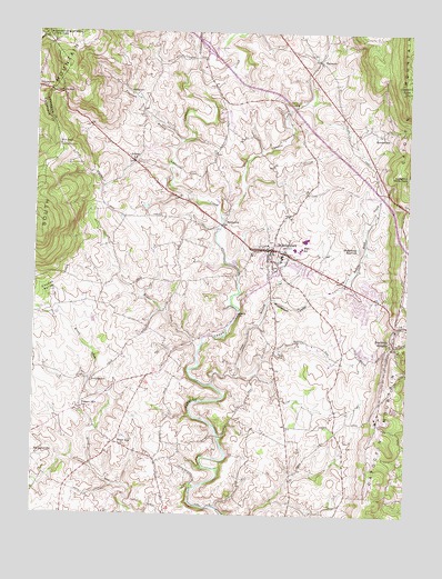
Middletown, MD USGS Topographic Map
Click on map above to begin viewing in our Map Viewer.

This topographic map contains these locations and features:
Feature Name Type Latitude Longitude GNIS ID View Map
Arch BridgePopulated PlaceN39.4479°W77.5008°1711556View Map
ArnoldtownPopulated PlaceN39.4095°W77.6058°589655View Map
BeachleyPopulated PlaceN39.3965°W77.5233°1711557View Map
BellemontePopulated PlaceN39.3973°W77.5969°1711558View Map
Bennies Hill Road BridgeBridgeN39.4095°W77.5694°1711559View Map
Bidle Hill AcresPopulated PlaceN39.4834°W77.5533°1711560View Map
Bidle Industrial ParkLocaleN39.4918°W77.5664°1711561View Map
BolivarPopulated PlaceN39.4665°W77.5917°583321View Map
Bolivar BranchStreamN39.4612°W77.5797°1711562View Map
Bolivar HeightsPopulated PlaceN39.4690°W77.5858°1711563View Map
Braddock EstatesPopulated PlaceN39.4145°W77.5067°1711565View Map
Braddock HeightsPopulated PlaceN39.4187°W77.5036°589794View Map
Braddock Heights Census Designated PlaceCensusN39.4115°W77.5008°2389228View Map
Braddock Heights Post OfficePost OfficeN39.4186°W77.5035°1711566View Map
Braddock Heights Volunteer Fire Company Station 12BuildingN39.4180°W77.5050°2085783View Map
Brandenburg EstatesPopulated PlaceN39.4198°W77.5919°1711567View Map
Broad RunPopulated PlaceN39.3937°W77.5975°589819View Map
Broad Run AcresPopulated PlaceN39.3893°W77.5869°1711568View Map
Brookridge NorthPopulated PlaceN39.4501°W77.5578°1711570View Map
Burkitts RunStreamN39.3865°W77.6044°1711571View Map
Capitol Heights Vokunteer Fire DepartmentBuildingN39.4792°W77.5219°2085738View Map
Catoctin AcresPopulated PlaceN39.4523°W77.5019°1711572View Map
Catoctin HillsPopulated PlaceN39.4565°W77.5417°1711573View Map
Christ Reformed ChurchChurchN39.4429°W77.5450°1711574View Map
Church of Saint Joseph of the Sacred Heart of JesusChurchN39.4843°W77.6186°1711577View Map
Coblentz HeightsPopulated PlaceN39.4051°W77.5083°1711578View Map
ColebrookPopulated PlaceN39.4126°W77.5455°1711579View Map
Cone BranchStreamN39.4090°W77.5642°583859View Map
Corner HousePopulated PlaceN39.3951°W77.5908°1711580View Map
Countryside WestPopulated PlaceN39.4393°W77.5761°1711581View Map
CowellPopulated PlaceN39.4529°W77.5608°1711582View Map
Crest Manor EstatesPopulated PlaceN39.4279°W77.5092°1711583View Map
Cross HollowPopulated PlaceN39.4815°W77.5239°1711584View Map
Deer Springs BranchStreamN39.4087°W77.5650°1711586View Map
Deerspring Dairy FarmLocaleN39.4119°W77.5142°2704510View Map
Der Spring FarmsPopulated PlaceN39.4195°W77.5178°1711585View Map
Distillery Lane CiderworksBuildingN39.3869°W77.6206°2704602View Map
District 22, BurkittsvilleCivilN39.3972°W77.6098°1929554View Map
District 3, MiddletownCivilN39.4485°W77.5581°1929585View Map
Edinburg ForestPopulated PlaceN39.4312°W77.5067°1711587View Map
Elm Springs FarmLocaleN39.4020°W77.5308°1711588View Map
Everhart School (historical)SchoolN39.4565°W77.5792°1711589View Map
Fink School (historical)SchoolN39.4362°W77.5978°1711590View Map
Fountain DalePopulated PlaceN39.4340°W77.5119°1711591View Map
Fountaindale SouthPopulated PlaceN39.4293°W77.5150°1711592View Map
Fox GapGapN39.4709°W77.6167°588773View Map
Foxfield MiddletownPopulated PlaceN39.4407°W77.5305°1711593View Map
Frederick MontessoriFrederick Montessori SchoolSchoolN39.4172°W77.5060°2132212View Map
FrostownPopulated PlaceN39.4832°W77.5894°590261View Map
Frostown BranchStreamN39.4715°W77.5750°584529View Map
Gambrill SouthPopulated PlaceN39.4668°W77.5164°1711594View Map
GlenoblePopulated PlaceN39.3904°W77.5422°1711595View Map
Glenridge EstatesPopulated PlaceN39.3804°W77.5164°1711596View Map
Grindstone RunStreamN39.4893°W77.5717°584773View Map
HarmonyPopulated PlaceN39.4929°W77.5300°590423View Map
Harmony Brethren CemeteryCemeteryN39.4945°W77.5367°1711597View Map
Harmony Brethren ChurchChurchN39.4943°W77.5333°1711598View Map
Harmony CemeteryCemeteryN39.4943°W77.5328°1711599View Map
Harmony KnollsPopulated PlaceN39.4987°W77.5358°1711600View Map
Harshman EstatesPopulated PlaceN39.4982°W77.5492°1711602View Map
HawbottomPopulated PlaceN39.4737°W77.5078°590438View Map
Hawbottom BranchStreamN39.4826°W77.5328°1711603View Map
Hawbottom HeightsPopulated PlaceN39.4743°W77.5067°1711604View Map
Hollow EstatesPopulated PlaceN39.4704°W77.5211°1711605View Map
Hollow Road CreekStreamN39.4301°W77.5467°585025View Map
Hollow Road EstatesPopulated PlaceN39.4607°W77.5100°1711606View Map
HolterPopulated PlaceN39.3987°W77.5136°1711607View Map
Homers DelightPopulated PlaceN39.4287°W77.5430°1711608View Map
HormanPopulated PlaceN39.3912°W77.5019°1711609View Map
Interchange 42CrossingN39.4959°W77.5683°1711610View Map
Johnson CemeteryCemeteryN39.4723°W77.5167°1711611View Map
KelviewPopulated PlaceN39.4162°W77.5414°1711612View Map
Koogles School (historical)SchoolN39.4815°W77.5622°1711613View Map
Lambs Knoll FarmLocaleN39.4329°W77.6186°1711614View Map
Little Catoctin CreekStreamN39.4512°W77.5617°585444View Map
Lockwood HeightsPopulated PlaceN39.4787°W77.5628°1711615View Map
Locust ValleyBasinN39.4309°W77.6233°585546View Map
Manor RunStreamN39.4001°W77.6178°1711616View Map
Middle CreekStreamN39.4176°W77.5692°585809View Map
MiddletownPopulated PlaceN39.4437°W77.5447°585831View Map
Middletown Branch LibraryBuildingN39.4423°W77.5419°2043114View Map
Middletown CemeteryCemeteryN39.4422°W77.5439°1711617View Map
Middletown Elementary SchoolSchoolN39.4441°W77.5380°1711618View Map
Middletown FarmLocaleN39.4550°W77.5586°2705147View Map
Middletown HeightsPopulated PlaceN39.4579°W77.5594°1711619View Map
Middletown High SchoolSchoolN39.4466°W77.5344°1711620View Map
Middletown LibraryBuildingN39.4423°W77.5422°1711621View Map
Middletown ManorPopulated PlaceN39.4348°W77.5355°1711622View Map
Middletown Middle SchoolSchoolN39.4440°W77.5359°1711623View Map
Middletown ParkParkN39.4462°W77.5289°1711624View Map
Middletown Post OfficePost OfficeN39.4357°W77.5180°1711625View Map
Middletown Primary SchoolSchoolN39.4369°W77.5395°2132726View Map
Middletown Recreational ParkParkN39.4398°W77.5447°1711626View Map
Middletown ReservoirReservoirN39.4444°W77.5166°585835View Map
Middletown SouthPopulated PlaceN39.4340°W77.5511°1711627View Map
Middletown United Methodist Chuch PreschoolSchoolN39.4298°W77.5092°2132351View Map
Middletown ValleyValleyN39.4308°W77.5463°585836View Map
Middletown Valley EstatesPopulated PlaceN39.4098°W77.5753°1711628View Map
Middletown ViewPopulated PlaceN39.4618°W77.5703°1711629View Map
Middletown Volunteer Fire Company Station 7BuildingN39.4431°W77.5457°2085778View Map
MinnickPopulated PlaceN39.4104°W77.5436°1711630View Map
MorningsidePopulated PlaceN39.4126°W77.5886°1711631View Map
MoserPopulated PlaceN39.4682°W77.5922°1711632View Map
Mount Tabor CemeteryCemeteryN39.4795°W77.5889°1711633View Map
Mount Tabor Church (historical)ChurchN39.4795°W77.5886°1711634View Map
North JeffersonPopulated PlaceN39.3759°W77.5450°1711635View Map
Oak ParkPopulated PlaceN39.4784°W77.5894°1711636View Map
Picnic Woods EstatesPopulated PlaceN39.4334°W77.5830°1711637View Map
Pleasant View CemeteryCemeteryN39.4029°W77.6086°1711638View Map
Pleasant View ChurchChurchN39.4029°W77.6086°586602View Map
Poffenberger Road BridgeBridgeN39.3815°W77.5714°1711639View Map
Quebec School (historical)SchoolN39.4176°W77.5797°1711640View Map
Remsberg AcresPopulated PlaceN39.4326°W77.5394°1711641View Map
Reno MonumentParkN39.4704°W77.6167°586806View Map
Reno School (historical)SchoolN39.4632°W77.6053°1711642View Map
Ridge Crest EstatesPopulated PlaceN39.4298°W77.5003°1711693View Map
Samuels RunStreamN39.3895°W77.6142°1711550View Map
Shadows of the Old SouthLocaleN39.4262°W77.6039°1711644View Map
Skyline EstatesPopulated PlaceN39.3879°W77.5114°1711645View Map
Skyline GardensPopulated PlaceN39.3959°W77.5089°1711646View Map
SomersetPopulated PlaceN39.4107°W77.5075°1711647View Map
SpoolsvillePopulated PlaceN39.4501°W77.5614°588728View Map
SpringdalePopulated PlaceN39.4176°W77.5097°1711648View Map
Station RoadsPopulated PlaceN39.4793°W77.5850°1711649View Map
StrawleighPopulated PlaceN39.3995°W77.5067°1711650View Map
SummersPopulated PlaceN39.4890°W77.5844°1711651View Map
Sunset ViewPopulated PlaceN39.3954°W77.5108°1711652View Map
Town Center Plaza Shopping CenterLocaleN39.4382°W77.5261°1711653View Map
Town of MiddletownCivilN39.4404°W77.5358°2391299View Map
Turners GapGapN39.4845°W77.6200°587919View Map
Tyler School (historical)SchoolN39.4740°W77.5169°1711654View Map
Valley HeightsPopulated PlaceN39.4015°W77.5108°1711655View Map
Valley OverlookPopulated PlaceN39.4207°W77.5805°1711656View Map
Valley View EstatesPopulated PlaceN39.4579°W77.5125°1711657View Map
WAFY-FM (Middletown)TowerN39.4182°W77.5005°598492View Map
WARX-FM (Hagerstown)TowerN39.4954°W77.6114°598486View Map
Waynes WayPopulated PlaceN39.3848°W77.5761°1711658View Map
West Middletown EstatesPopulated PlaceN39.4482°W77.5722°1711659View Map
WestchesterPopulated PlaceN39.4645°W77.5430°1711660View Map
Wiles BranchStreamN39.4401°W77.5597°1711661View Map
Wiles EstatesPopulated PlaceN39.4776°W77.5600°1711662View Map
Wilmar FarmsLocaleN39.4590°W77.5194°1711663View Map
WJTM-FM (Frederick)TowerN39.4182°W77.5005°598479View Map
WoodcrestPopulated PlaceN39.4518°W77.6005°1711664View Map
Zion Lutheran CemeteryCemeteryN39.4460°W77.5457°1711665View Map
Zion Lutheran ChurchChurchN39.4443°W77.5469°1711666View Map
ZittlestownPopulated PlaceN39.4854°W77.6239°591623View Map

Note: Coordinates in the location and feature list above are referenced to NAD83 datum.


Copyright (C) 2008-2024 Ryan Niemi / Sunset Dynamics ... All Rights Reserved