TopoQuest Logo
Do you find TopoQuest useful?
Help keep TopoQuest running and adding new maps/features by donating!
Bitcoin:  19c7KJd3qBynnjoSw5npx9KScwjBe4ifkT
Litecoin:  LXs6TkuXGGXo1vDsWCkWVdjQX94eUKd6ui
Home View Maps Find Maps Find Places Resources & Links


Miners Delight, Wyoming Topographic Map

USGS Map Title: Miners Delight, WY
USGS Map MRC: 42108E6
DRG (GeoTIFF) Download: o42108e6.tif


Neighboring USGS Topographic Map Quads:


  Fossil Hill, WY  
42108F7
 

  Wolf Point, WY  
42108F6
 

  Weiser Pass, WY  
42108F5
 

  Louis Lake, WY  
42108E7
 

  Miners Delight, WY  
42108E6
 

  Gravel Spring, WY  
42108E5
 

  South Pass City, WY  
42108D7
 

  Atlantic City, WY  
42108D6
 

  Radium Springs, WY  
42108D5


Map MRC Location:

N43°
W109°
N43°
W108°
H8 H7 H6 H5 H4 H3 H2 H1
G8 G7 G6 G5 G4 G3 G2 G1
F8 F7 F6 F5 F4 F3 F2 F1
E8 E7 E6 E5 E4 E3 E2 E1
D8 D7 D6 D5 D4 D3 D2 D1
C8 C7 C6 C5 C4 C3 C2 C1
B8 B7 B6 B5 B4 B3 B2 B1
A8 A7 A6 A5 A4 A3 A2 A1
N42°
W109°
N42°
W108°

Miners Delight, WY USGS 1:24K Topographic Map Preview:
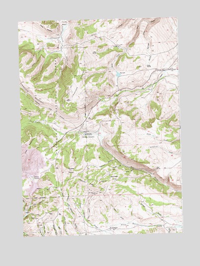
Miners Delight, WY USGS Topographic Map
Click on map above to begin viewing in our Map Viewer.

This topographic map contains these locations and features:
Feature Name Type Latitude Longitude GNIS ID View Map
Arasta GulchValleyN42.5180°W108.7443°1597792View Map
Atlantic City Census Designated PlaceCensusN42.5012°W108.7329°2407777View Map
Beaver Creek Counting PensLocaleN42.5588°W108.6982°1598066View Map
Caribou MineMineN42.5130°W108.7273°1598630View Map
Cole GulchValleyN42.5186°W108.7151°1598854View Map
Columbia Geneva MinesMineN42.5466°W108.7462°1605093View Map
Copper Chief Gold MineMineN42.5236°W108.6896°1746461View Map
Crows Nest GulchValleyN42.5033°W108.6357°1599057View Map
Cutler GulchValleyN42.5133°W108.7465°1599093View Map
Derby SpringSpringN42.5975°W108.6503°1599225View Map
Derby Springs DrawValleyN42.6219°W108.6465°1599226View Map
Diana MineMineN42.5066°W108.7387°1599243View Map
Dry LakeLakeN42.5928°W108.6726°1599368View Map
Fire King DepositMineN42.5417°W108.7433°1746462View Map
Fort Stambaugh HistoricalLocaleN42.5036°W108.6807°1599801View Map
Garfield MineMineN42.5108°W108.7412°1599908View Map
Gold Dollar MineMineN42.5241°W108.6948°1599962View Map
Goldman MeadowsLakeN42.5294°W108.7383°1599974View Map
High SpringSpringN42.5374°W108.6452°1600332View Map
Horace GulchValleyN42.5025°W108.6259°1600385View Map
Irish GulchValleyN42.5066°W108.6671°1600523View Map
KCWC-FM (Riverton)TowerN42.5830°W108.7107°1608938View Map
KCWC-TV (Lander)TowerN42.5830°W108.7107°1608954View Map
Lander DivisionCivilN42.5804°W108.6952°1939720View Map
Limestone MountainSummitN42.5761°W108.7257°1600921View Map
Meadow GulchValleyN42.5438°W108.6765°1601331View Map
Midas MineMineN42.5122°W108.7282°1746463View Map
Miners DelightPopulated PlaceN42.5330°W108.6807°1601480View Map
Miners Delight CemeteryCemeteryN42.5317°W108.6779°2774463View Map
Miners Delight MineMineN42.5311°W108.6879°1601481View Map
Omera MeadowFlatN42.5572°W108.6901°1601923View Map
Omera SpringSpringN42.5602°W108.7010°1601924View Map
Pat Royce SpringSpringN42.6093°W108.6729°1602056View Map
Peabody RidgeRidgeN42.5302°W108.6990°1602063View Map
Pine SpringSpringN42.6055°W108.6894°1602168View Map
Placerita GulchValleyN42.5197°W108.7143°1602203View Map
Promise GulchValleyN42.5088°W108.7001°1602310View Map
Red Canyon Rim MineMineN42.6172°W108.6498°1726467View Map
Rock Creek MineMineN42.5447°W108.7473°1746464View Map
Roundtop MountainSummitN42.5380°W108.7129°1602640View Map
Sheldon GulchValleyN42.5258°W108.7421°1602863View Map
Slate CreekStreamN42.5150°W108.7484°1602966View Map
Snow CreekStreamN42.5255°W108.7432°1603026View Map
Snow CreekStreamN42.6144°W108.7218°1603027View Map
South Pass Ski TowLocaleN42.5344°W108.7490°1605472View Map
Spring GulchValleyN42.5380°W108.6623°1603282View Map
Yankee GulchValleyN42.5402°W108.6696°1604305View Map

Note: Coordinates in the location and feature list above are referenced to NAD83 datum.


Copyright (C) 2008-2024 Ryan Niemi / Sunset Dynamics ... All Rights Reserved