TopoQuest Logo
Do you find TopoQuest useful?
Help keep TopoQuest running and adding new maps/features by donating!
Bitcoin:  19c7KJd3qBynnjoSw5npx9KScwjBe4ifkT
Litecoin:  LXs6TkuXGGXo1vDsWCkWVdjQX94eUKd6ui
Home View Maps Find Maps Find Places Resources & Links


Muscatine NW, Iowa Topographic Map

USGS Map Title: Muscatine NW, IA
USGS Map MRC: 41091D2
DRG (GeoTIFF) Download: o41091d2.tif


Neighboring USGS Topographic Map Quads:


  West Liberty, IA  
41091E3
 

  Atalissa, IA  
41091E2
 

  Wilton, IA  
41091E1
 

  Nichols, IA  
41091D3
 

  Muscatine NW, IA  
41091D2
 

  Muscatine, IA  
41091D1
 

  Columbus Junction, IA  
41091C3
 

  Letts, IA  
41091C2
 

  Blanchard Island, IL  
41091C1


Map MRC Location:

N42°
W92°
N42°
W91°
H8 H7 H6 H5 H4 H3 H2 H1
G8 G7 G6 G5 G4 G3 G2 G1
F8 F7 F6 F5 F4 F3 F2 F1
E8 E7 E6 E5 E4 E3 E2 E1
D8 D7 D6 D5 D4 D3 D2 D1
C8 C7 C6 C5 C4 C3 C2 C1
B8 B7 B6 B5 B4 B3 B2 B1
A8 A7 A6 A5 A4 A3 A2 A1
N41°
W92°
N41°
W91°

Muscatine NW, IA USGS 1:24K Topographic Map Preview:
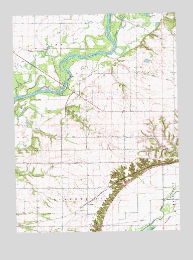
Muscatine NW, IA USGS Topographic Map
Click on map above to begin viewing in our Map Viewer.

This topographic map contains these locations and features:
Feature Name Type Latitude Longitude GNIS ID View Map
Adams (historical)LocaleN41.4828°W91.2435°465522View Map
Adams Post Office (historical)Post OfficeN41.4828°W91.2435°2000464View Map
ArdonPopulated PlaceN41.3950°W91.1885°464446View Map
Ardon (historical)LocaleN41.3950°W91.1885°2000462View Map
Ardon CemeteryCemeteryN41.3852°W91.1957°454221View Map
Ardon Post Office (historical)Post OfficeN41.3950°W91.1885°2000463View Map
Bayfield (historical)LocaleN41.4661°W91.1529°2000461View Map
Bayfield Post Office (historical)Post OfficeN41.4661°W91.1529°2000460View Map
Breakenridge Ferry (historical)LocaleN41.4736°W91.2088°465521View Map
Camp SacalaweaLocaleN41.4995°W91.1302°455131View Map
Chicken CreekStreamN41.4834°W91.1718°455389View Map
Clearview ChurchChurchN41.4870°W91.1268°455469View Map
DayfieldPopulated PlaceN41.4650°W91.1513°464284View Map
High Prairie CemeteryCemeteryN41.4284°W91.1656°2000612View Map
High Prairie ChurchChurchN41.4284°W91.1660°457451View Map
Houtz CemeteryCemeteryN41.4150°W91.2003°457686View Map
Keokuk Lake (historical)LakeN41.3756°W91.1495°458055View Map
Pike RunStreamN41.4536°W91.2479°460138View Map
Pike Run Wildlife AreaParkN41.4889°W91.2085°2000446View Map
Saint Johns CemeteryCemeteryN41.4200°W91.2146°461012View Map
Saint Malachys ChurchChurchN41.3909°W91.1954°461146View Map
Seventy-Six TownhallBuildingN41.3925°W91.2140°463609View Map
Shield Prairie AreaParkN41.4806°W91.1257°2000445View Map
Township of LakeCivilN41.4551°W91.1737°468182View Map
Township of Seventy-SixCivilN41.3809°W91.2009°468681View Map

Note: Coordinates in the location and feature list above are referenced to NAD83 datum.


Copyright (C) 2008-2024 Ryan Niemi / Sunset Dynamics ... All Rights Reserved