TopoQuest Logo
Do you find TopoQuest useful?
Help keep TopoQuest running and adding new maps/features by donating!
Bitcoin:  19c7KJd3qBynnjoSw5npx9KScwjBe4ifkT
Litecoin:  LXs6TkuXGGXo1vDsWCkWVdjQX94eUKd6ui
Home View Maps Find Maps Find Places Resources & Links


Napoleonville SW, Louisiana Topographic Map

USGS Map Title: Napoleonville SW, LA
USGS Map MRC: 29091G2
DRG (GeoTIFF) Download: o29091g2.tif


Neighboring USGS Topographic Map Quads:


  Centerville NE, LA  
29091H3
 

  Pierre Part, LA  
29091H2
 

  Napoleonville, LA  
29091H1
 

  Tiger Island, LA  
29091G3
 

  Napoleonville SW, LA  
29091G2
 

  Grassy Lake, LA  
29091G1
 

  Patterson, LA  
29091F3
 

  Morgan City, LA  
29091F2
 

  Amelia, LA  
29091F1


Map MRC Location:

N30°
W92°
N30°
W91°
H8 H7 H6 H5 H4 H3 H2 H1
G8 G7 G6 G5 G4 G3 G2 G1
F8 F7 F6 F5 F4 F3 F2 F1
E8 E7 E6 E5 E4 E3 E2 E1
D8 D7 D6 D5 D4 D3 D2 D1
C8 C7 C6 C5 C4 C3 C2 C1
B8 B7 B6 B5 B4 B3 B2 B1
A8 A7 A6 A5 A4 A3 A2 A1
N29°
W92°
N29°
W91°

Napoleonville SW, LA USGS 1:24K Topographic Map Preview:
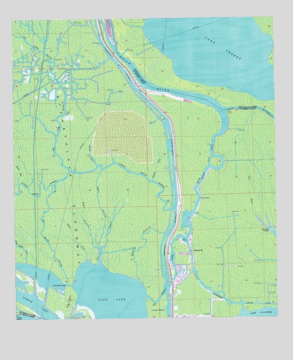
Napoleonville SW, LA USGS Topographic Map
Click on map above to begin viewing in our Map Viewer.

This topographic map contains these locations and features:
Feature Name Type Latitude Longitude GNIS ID View Map
Bayou CaneStreamN29.7741°W91.2157°559888View Map
Bayou ChevreuilStreamN29.7797°W91.2095°559904View Map
Bayou CocodrieStreamN29.7791°W91.2098°559910View Map
Bayou GrosbeakStreamN29.7655°W91.1918°559973View Map
Bayou GunnieStreamN29.8141°W91.2101°559976View Map
Bayou JuneStreamN29.8066°W91.2476°559991View Map
Bayou LongStreamN29.7663°W91.1745°560009View Map
Bayou MilhommeStreamN29.7541°W91.1418°560033View Map
Bayou SamStreamN29.8074°W91.1840°560076View Map
Bear BayouStreamN29.7716°W91.2093°560117View Map
Belle RiverStreamN29.8369°W91.1501°560140View Map
Big Bayou JessieStreamN29.7649°W91.2248°560167View Map
Big Fork BayouStreamN29.8121°W91.2232°560182View Map
Dog IslandIslandN29.7574°W91.2248°560633View Map
Dog Island PassChannelN29.7647°W91.2248°560634View Map
Flat LakeLakeN29.7516°W91.2037°560762View Map
Graveyard IslandIslandN29.8716°W91.2037°560897View Map
Hog BayouStreamN29.7908°W91.1334°560972View Map
Holy Cross ChurchChurchN29.8002°W91.1609°560986View Map
KFXY-FM (Morgan City)TowerN29.7510°W91.1734°1633082View Map
KMRC-AM (Morgan City)TowerN29.7510°W91.1734°1633206View Map
KVPO-FM (Berwick)TowerN29.7577°W91.1737°1633046View Map
Little Bayou JessieStreamN29.7735°W91.2443°1627498View Map
Little Bayou SorrelStreamN29.7958°W91.1748°1627501View Map
Stephensville Elementary SchoolSchoolN29.7597°W91.1744°551558View Map
Stephensville Gas FieldOilfieldN29.7827°W91.1445°551559View Map
Stephensville Volunteer Fire DepartmentBuildingN29.7768°W91.1666°2332704View Map
Stephensville Wastewater Treatment PlantLocaleN29.7727°W91.1646°2603510View Map
StephenvillePopulated PlaceN29.7783°W91.1659°1628294View Map
West Lake Verret Oil and Gas FieldOilfieldN29.8566°W91.2345°1628476View Map

Note: Coordinates in the location and feature list above are referenced to NAD83 datum.


Copyright (C) 2008-2024 Ryan Niemi / Sunset Dynamics ... All Rights Reserved