TopoQuest Logo
Do you find TopoQuest useful?
Help keep TopoQuest running and adding new maps/features by donating!
Bitcoin:  19c7KJd3qBynnjoSw5npx9KScwjBe4ifkT
Litecoin:  LXs6TkuXGGXo1vDsWCkWVdjQX94eUKd6ui
Home View Maps Find Maps Find Places Resources & Links


Narcoossee NW, Florida Topographic Map

USGS Map Title: Narcoossee NW, FL
USGS Map MRC: 28081D2
DRG (GeoTIFF) Download: o28081d2.tif


Neighboring USGS Topographic Map Quads:


  Orlando East, FL  
28081E3
 

  Oviedo SW, FL  
28081E2
 

  Bithlo, FL  
28081E1
 

  Pine Castle, FL  
28081D3
 

  Narcoossee NW, FL  
28081D2
 

  Narcoossee NE, FL  
28081D1
 

  Saint Cloud North, FL  
28081C3
 

  Narcoossee, FL  
28081C2
 

  Narcoossee SE, FL  
28081C1


Map MRC Location:

N29°
W82°
N29°
W81°
H8 H7 H6 H5 H4 H3 H2 H1
G8 G7 G6 G5 G4 G3 G2 G1
F8 F7 F6 F5 F4 F3 F2 F1
E8 E7 E6 E5 E4 E3 E2 E1
D8 D7 D6 D5 D4 D3 D2 D1
C8 C7 C6 C5 C4 C3 C2 C1
B8 B7 B6 B5 B4 B3 B2 B1
A8 A7 A6 A5 A4 A3 A2 A1
N28°
W82°
N28°
W81°

Narcoossee NW, FL USGS 1:24K Topographic Map Preview:
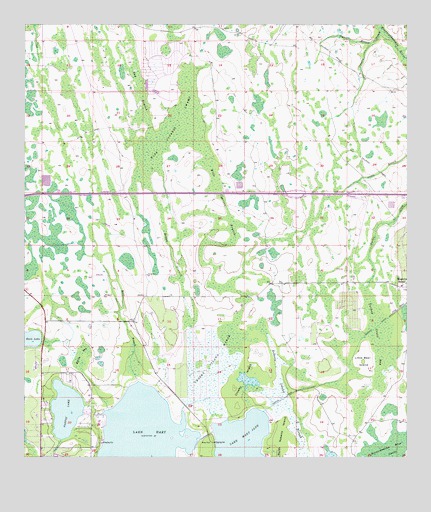
Narcoossee NW, FL USGS Topographic Map
Click on map above to begin viewing in our Map Viewer.

This topographic map contains these locations and features:
Feature Name Type Latitude Longitude GNIS ID View Map
Barton LakeLakeN28.3890°W81.2362°278135View Map
Barton Lake Mobile Home ParkPopulated PlaceN28.3905°W81.2428°2451153View Map
Bay BranchGutN28.4819°W81.2123°278185View Map
Boggy BranchGutN28.4364°W81.2023°279146View Map
Buck LakeLakeN28.4085°W81.2492°279580View Map
Cowpen BranchStreamN28.4989°W81.1331°280957View Map
Crosby IslandIslandN28.3964°W81.1787°281082View Map
Crosby Island MarshSwampN28.4033°W81.1894°281083View Map
Disston CanalCanalN28.4017°W81.1440°281589View Map
Florida Department of Corrections Central Florida Reception CenterBuildingN28.4635°W81.1561°2451588View Map
Florida Department of Corrections Central Florida Reception Center East UnitBuildingN28.4631°W81.1493°2451587View Map
Florida Department of Corrections Central Florida Reception Center South UnitBuildingN28.4534°W81.1593°2753041View Map
Haines City PlazaLocaleN28.4669°W81.1303°296471View Map
Hart BranchStreamN28.3961°W81.2090°283776View Map
Hart BranchStreamN28.4947°W81.1367°283777View Map
Lake HartLakeN28.3796°W81.2114°283786View Map
Lake HartPopulated PlaceN28.3928°W81.2406°1853262View Map
Lake Hart Census Designated PlaceCensusN28.3859°W81.2339°2403192View Map
Lake Mary Jane Census Designated PlaceCensusN28.3768°W81.1601°2583358View Map
Little Bear IslandIslandN28.4028°W81.1392°285597View Map
Moss ParkParkN28.3786°W81.1901°287177View Map
Myrtle BaySwampN28.4042°W81.2313°287501View Map
Orange County Fire Rescue Station 76BuildingN28.4021°W81.2438°2331343View Map
Orange County Fire Rescue Station 77BuildingN28.3993°W81.2055°2644661View Map
Orlando Fire Department Station 15BuildingN28.4187°W81.2430°2644607View Map
Orlando Police Department - Lake Nona Community OfficeBuildingN28.4118°W81.2415°2756063View Map
Quail West Golf and Country ClubLocaleN28.4057°W81.2236°2451143View Map
Roberts Island SloughSwampN28.3853°W81.1621°289783View Map
Stanton Energy CenterLocaleN28.4825°W81.1676°2451586View Map
Tala Apopka (historical)Populated PlaceN28.4669°W81.1831°294496View Map
Turkey Creek BaySwampN28.4064°W81.1287°292522View Map
Whippoorwill Mobile Home ParkPopulated PlaceN28.3856°W81.2428°2451585View Map
Wide Cypress BranchGutN28.4522°W81.1862°293265View Map
Wide Cypress SwampSwampN28.4688°W81.2014°293266View Map
Yalaka (historical)Populated PlaceN28.4003°W81.1665°294493View Map

Note: Coordinates in the location and feature list above are referenced to NAD83 datum.


Copyright (C) 2008-2024 Ryan Niemi / Sunset Dynamics ... All Rights Reserved