TopoQuest Logo
Do you find TopoQuest useful?
Help keep TopoQuest running and adding new maps/features by donating!
Bitcoin:  19c7KJd3qBynnjoSw5npx9KScwjBe4ifkT
Litecoin:  LXs6TkuXGGXo1vDsWCkWVdjQX94eUKd6ui
Home View Maps Find Maps Find Places Resources & Links


New Hope, Alabama Topographic Map

USGS Map Title: New Hope, AL
USGS Map MRC: 34086E4
DRG (GeoTIFF) Download: o34086e4.tif


Neighboring USGS Topographic Map Quads:


  Huntsville, AL  
34086F5
 

  Moontown, AL  
34086F4
 

  Paint Rock, AL  
34086F3
 

  Farley, AL  
34086E5
 

  New Hope, AL  
34086E4
 

  Grant, AL  
34086E3
 

  Newsome Sinks, AL  
34086D5
 

  Guntersville Dam, AL  
34086D4
 

  Mount Carmel, AL  
34086D3


Map MRC Location:

N35°
W87°
N35°
W86°
H8 H7 H6 H5 H4 H3 H2 H1
G8 G7 G6 G5 G4 G3 G2 G1
F8 F7 F6 F5 F4 F3 F2 F1
E8 E7 E6 E5 E4 E3 E2 E1
D8 D7 D6 D5 D4 D3 D2 D1
C8 C7 C6 C5 C4 C3 C2 C1
B8 B7 B6 B5 B4 B3 B2 B1
A8 A7 A6 A5 A4 A3 A2 A1
N34°
W87°
N34°
W86°

New Hope, AL USGS 1:24K Topographic Map Preview:
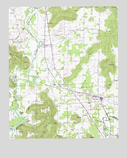
New Hope, AL USGS Topographic Map
Click on map above to begin viewing in our Map Viewer.

This topographic map contains these locations and features:
Feature Name Type Latitude Longitude GNIS ID View Map
Baker CemeteryCemeteryN34.6040°W86.4416°113373View Map
Baker SpringSpringN34.6019°W86.4249°113392View Map
Bethlehem Baptist ChurchChurchN34.6031°W86.4142°146687View Map
Big CoveValleyN34.5795°W86.4722°114251View Map
Big Cove Holiness ChurchChurchN34.6195°W86.4939°114252View Map
Blue SpringSpringN34.5201°W86.4003°114566View Map
Blue Spring BranchStreamN34.5137°W86.3905°114581View Map
Brazelton SpringSpringN34.5812°W86.4825°114858View Map
Buck Ford BendBendN34.5081°W86.3900°115128View Map
Buford CemeteryCemeteryN34.5915°W86.4903°115162View Map
Buggs ChapelLocaleN34.5509°W86.4430°115165View Map
Burr HollowValleyN34.5384°W86.4919°115274View Map
Bush CemeteryCemeteryN34.5345°W86.4630°115294View Map
Byrd CemeteryCemeteryN34.6015°W86.4419°115340View Map
Carpenter Bridge (historical)BridgeN34.5870°W86.4667°146745View Map
Cave SpringSpringN34.6031°W86.4136°115722View Map
Cave SpringSpringN34.6245°W86.4016°115723View Map
Cave Spring Baptist ChurchChurchN34.6034°W86.4183°146751View Map
Cave Spring School (historical)SchoolN34.6023°W86.4097°146819View Map
Cave Springs Holiness ChurchChurchN34.5926°W86.4144°115729View Map
Cedar Grove CemeteryCemeteryN34.5306°W86.4464°115777View Map
Cedar Grove Church (historical)ChurchN34.5298°W86.4461°146755View Map
Cedar RidgeRidgeN34.5740°W86.4158°115811View Map
Chandler CemeteryCemeteryN34.5992°W86.3978°115936View Map
Christ Holy Temple ChurchChurchN34.6029°W86.4244°146782View Map
Christian MountainSummitN34.6168°W86.4430°146784View Map
Christian PointCapeN34.6095°W86.4489°116101View Map
Church of ChristChurchN34.5812°W86.4586°146788View Map
City of New HopeCivilN34.5371°W86.4128°2404361View Map
Colliers Chapel ChurchChurchN34.5851°W86.4325°146809View Map
Cross CemeteryCemeteryN34.5709°W86.4908°146831View Map
Drake CemeteryCemeteryN34.5623°W86.3983°117455View Map
ElonPopulated PlaceN34.5429°W86.4689°156311View Map
Elon ChurchChurchN34.5445°W86.4642°146871View Map
Flint River Ranch AirportAirportN34.6201°W86.4654°2676314View Map
Galilee ChurchChurchN34.5493°W86.4417°118783View Map
Gibson CemeteryCemeteryN34.5062°W86.4886°118924View Map
Glover CemeteryCemeteryN34.6129°W86.4225°119054View Map
Glover ChapelChurchN34.6084°W86.3961°119055View Map
Glover CoveValleyN34.6151°W86.3967°119056View Map
Glover Cove CreekStreamN34.5923°W86.4619°146930View Map
Grayson SpringSpringN34.5920°W86.4890°119308View Map
Green Valley CemeteryCemeteryN34.6131°W86.4897°153833View Map
Hampton CovePopulated PlaceN34.6135°W86.4638°2108414View Map
Haymer ChapelChurchN34.5343°W86.4100°119897View Map
Haymer MountainSummitN34.5198°W86.4236°119898View Map
Hill MountainSummitN34.5693°W86.3864°120107View Map
Hines GapGapN34.6215°W86.4253°120148View Map
Honea HollowValleyN34.6101°W86.3919°120318View Map
Lacy HollowValleyN34.6045°W86.3953°121305View Map
Lemley MountainSummitN34.5281°W86.4580°121496View Map
Little Blue SpringSpringN34.5190°W86.3811°139418View Map
Low GapGapN34.5798°W86.4094°122068View Map
Lowe (historical)Populated PlaceN34.5868°W86.4147°139427View Map
Macedonia GapGapN34.5029°W86.4461°122174View Map
McGehee SpringSpringN34.5030°W86.3758°122548View Map
McKinney MountainSummitN34.5134°W86.4550°122578View Map
Meeks MountainSummitN34.5065°W86.4769°122630View Map
Moon CemeteryCemeteryN34.5979°W86.4466°122979View Map
Mount Zion ChurchChurchN34.5145°W86.4436°123436View Map
Mountain Grove Church (historical)ChurchN34.5598°W86.3972°1700612View Map
Neal Chapel CemeteryCemeteryN34.5943°W86.4947°123659View Map
New HopePopulated PlaceN34.5370°W86.3944°155171View Map
New Hope CemeteryCemeteryN34.5320°W86.3958°123786View Map
New Hope DivisionCivilN34.5592°W86.4404°165869View Map
New Hope Police DepartmentBuildingN34.5369°W86.3944°2751722View Map
New Hope Post OfficePost OfficeN34.5380°W86.3944°2789030View Map
New Hope SchoolSchoolN34.5406°W86.3983°147146View Map
New Hope SpringSpringN34.5209°W86.3842°123851View Map
New Hope SpringSpringN34.5365°W86.3939°1700613View Map
New Hope Volunteer Fire DepartmentBuildingN34.5369°W86.3952°2682867View Map
Oak Bower ChurchChurchN34.5512°W86.4467°124055View Map
Oak GrovePopulated PlaceN34.5145°W86.4380°156812View Map
Oak Grove ChurchChurchN34.5148°W86.4250°124069View Map
Oak Grove School (historical)SchoolN34.5145°W86.4375°1700614View Map
Opossum HollowValleyN34.5651°W86.4933°124292View Map
Owen Crossroads Church of GodChurchN34.5668°W86.4489°147176View Map
Owen Crossroads First Methodist ChurchChurchN34.5793°W86.4489°147177View Map
Owens Cross RoadsPopulated PlaceN34.5881°W86.4589°155184View Map
Owens Cross Roads Middle SchoolSchoolN34.5881°W86.4561°147178View Map
Owens Cross Roads Police DepartmentBuildingN34.5841°W86.4513°2751814View Map
Owens Cross Roads Post OfficePost OfficeN34.6058°W86.4551°166722View Map
Owens Cross Roads Volunteer Fire Department Station 1BuildingN34.5904°W86.4586°2682735View Map
Owens Cross Roads Volunteer Fire Department Station 2BuildingN34.6028°W86.4147°2683114View Map
Pond CreekStreamN34.5234°W86.3853°125117View Map
Potato HillSummitN34.5729°W86.4836°125201View Map
Roach MountainSummitN34.5012°W86.4083°125679View Map
Rock SpringSpringN34.5777°W86.4788°125773View Map
Russell IslandIslandN34.5537°W86.4928°126036View Map
Stewart CemeteryCemeteryN34.5243°W86.4722°127378View Map
Sugar ForkStreamN34.5173°W86.4833°127506View Map
Sweatman SpringSpringN34.5053°W86.4138°127579View Map
Swift FordCrossingN34.5579°W86.4680°157136View Map
Tarkiln BranchStreamN34.5584°W86.4689°127694View Map
The BayouStreamN34.5162°W86.3986°127794View Map
Town of Owens Cross RoadsCivilN34.5845°W86.4575°2407060View Map
Union ChurchChurchN34.5356°W86.4686°128277View Map
Union Grove School (historical)SchoolN34.5476°W86.4528°147329View Map
Vann School (historical)SchoolN34.6084°W86.4925°147342View Map
Walnut Grove ChurchChurchN34.5540°W86.3758°128554View Map
Webster HollowValleyN34.6059°W86.3917°128689View Map
Yellow Bank CreekStreamN34.5543°W86.4697°129278View Map

Note: Coordinates in the location and feature list above are referenced to NAD83 datum.


Copyright (C) 2008-2024 Ryan Niemi / Sunset Dynamics ... All Rights Reserved