TopoQuest Logo
Do you find TopoQuest useful?
Help keep TopoQuest running and adding new maps/features by donating!
Bitcoin:  19c7KJd3qBynnjoSw5npx9KScwjBe4ifkT
Litecoin:  LXs6TkuXGGXo1vDsWCkWVdjQX94eUKd6ui
Home View Maps Find Maps Find Places Resources & Links


Abbotsford, Wisconsin Topographic Map

USGS Map Title: Abbotsford, WI
USGS Map MRC: 44090H3
DRG (GeoTIFF) Download: o44090h3.tif


Neighboring USGS Topographic Map Quads:


  Medford SW, WI  
45090A4
 

  Stetsonville, WI  
45090A3
 

  Corinth, WI  
45090A2
 

  Curtiss, WI  
44090H4
 

  Abbotsford, WI  
44090H3
 

  Milan, WI  
44090H2
 

  Riplinger, WI  
44090G4
 

  Spencer North, WI  
44090G3
 

  Little Rose, WI  
44090G2


Map MRC Location:

N45°
W91°
N45°
W90°
H8 H7 H6 H5 H4 H3 H2 H1
G8 G7 G6 G5 G4 G3 G2 G1
F8 F7 F6 F5 F4 F3 F2 F1
E8 E7 E6 E5 E4 E3 E2 E1
D8 D7 D6 D5 D4 D3 D2 D1
C8 C7 C6 C5 C4 C3 C2 C1
B8 B7 B6 B5 B4 B3 B2 B1
A8 A7 A6 A5 A4 A3 A2 A1
N44°
W91°
N44°
W90°

Abbotsford, WI USGS 1:24K Topographic Map Preview:
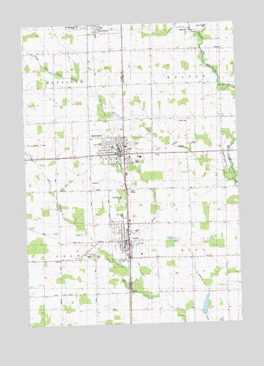
Abbotsford, WI USGS Topographic Map
Click on map above to begin viewing in our Map Viewer.

This topographic map contains these locations and features:
Feature Name Type Latitude Longitude GNIS ID View Map
13-29 Drive-In (historical)LocaleN44.9300°W90.3142°2678001View Map
AbbotsfordPopulated PlaceN44.9464°W90.3160°1560663View Map
Abbotsford Christian AcademySchoolN44.9465°W90.2832°2713314View Map
Abbotsford Elementary SchoolSchoolN44.9464°W90.3216°1837633View Map
Abbotsford Fire Department and Ambulance ServiceBuildingN44.9472°W90.3182°2697512View Map
Abbotsford Middle / Senior High SchoolSchoolN44.9502°W90.3305°1837634View Map
Abbotsford PondReservoirN44.9772°W90.2601°2770682View Map
Abbotsford Public CemeteryCemeteryN44.9561°W90.3179°1837635View Map
Abbotsford Wastewater Treatment FacilityLocaleN44.9422°W90.3108°2376930View Map
City of AbbotsfordCivilN44.9437°W90.3153°1582650View Map
City of ColbyCivilN44.9108°W90.3156°1582997View Map
ColbyPopulated PlaceN44.9100°W90.3157°1563232View Map
Colby - Abbotsford Police DepartmentBuildingN44.9464°W90.3220°2759646View Map
Colby CemeteryCemeteryN44.9033°W90.3362°1563233View Map
Colby Elementary SchoolSchoolN44.9187°W90.3204°2715790View Map
Colby High SchoolSchoolN44.9203°W90.3188°1837647View Map
Colby Middle SchoolSchoolN44.9191°W90.3190°2715791View Map
Colby Volunteer Fire DepartmentBuildingN44.9057°W90.3169°2697829View Map
Colby Wastewater Treatment PlantLocaleN44.9017°W90.3225°2723704View Map
Colby-Abbotsford Airport (historical)AirportN44.9277°W90.3182°1837648View Map
Elm BrookStreamN44.8889°W90.3118°1564553View Map
First United Church of ChristChurchN44.9089°W90.3182°1837660View Map
First United Presbyterian ChurchChurchN44.9441°W90.3274°1837661View Map
Holton CemeteryCemeteryN44.9605°W90.2801°1566572View Map
Jones AirportAirportN44.9705°W90.3462°1581945View Map
Little Stars PreschoolSchoolN44.9202°W90.3188°2715752View Map
Pickard School (historical)SchoolN44.9822°W90.2990°1876721View Map
Pleasant Hill SchoolSchoolN44.9741°W90.3462°1571608View Map
Pleasant Hill School (historical)SchoolN44.8880°W90.2790°1876723View Map
Porky CreekStreamN44.9347°W90.2535°1571791View Map
Riverside School (historical)SchoolN44.9308°W90.2532°1876729View Map
Riverview Airport (historical)AirportN44.9422°W90.2582°1581851View Map
Rosedale School (historical)SchoolN44.9605°W90.2599°1876732View Map
Saint Mary's Grade SchoolSchoolN44.9069°W90.3182°1837732View Map
Saint Marys Catholic ChurchChurchN44.9075°W90.3182°1837730View Map
Saint Pius X MonasteryChurchN44.8869°W90.3349°1573553View Map
Town of HoltonCivilN44.9902°W90.2559°1583405View Map
Town of HullCivilN44.9011°W90.2537°1583420View Map
Winding Creek Rearing Pond 1ReservoirN44.8821°W90.2713°1792620View Map
Winding Creek Rearing Pond 3WR481 DamDamN44.8800°W90.2718°1792619View Map

Note: Coordinates in the location and feature list above are referenced to NAD83 datum.


Copyright (C) 2008-2024 Ryan Niemi / Sunset Dynamics ... All Rights Reserved