TopoQuest Logo
Do you find TopoQuest useful?
Help keep TopoQuest running and adding new maps/features by donating!
Bitcoin:  19c7KJd3qBynnjoSw5npx9KScwjBe4ifkT
Litecoin:  LXs6TkuXGGXo1vDsWCkWVdjQX94eUKd6ui
Home View Maps Find Maps Find Places Resources & Links


Parkesburg, Pennsylvania Topographic Map

USGS Map Title: Parkesburg, PA
USGS Map MRC: 39075H8
DRG (GeoTIFF) Download: o39075h8.tif


Neighboring USGS Topographic Map Quads:


  New Holland, PA  
40076A1
 

  Honey Brook, PA  
40075A8
 

  Wagontown, PA  
40075A7
 

  Gap, PA  
39076H1
 

  Parkesburg, PA  
39075H8
 

  Coatesville, PA  
39075H7
 

  Kirkwood, PA  
39076G1
 

  Oxford, PA  
39075G8
 

  West Grove, PA  
39075G7


Map MRC Location:

N40°
W76°
N40°
W75°
H8 H7 H6 H5 H4 H3 H2 H1
G8 G7 G6 G5 G4 G3 G2 G1
F8 F7 F6 F5 F4 F3 F2 F1
E8 E7 E6 E5 E4 E3 E2 E1
D8 D7 D6 D5 D4 D3 D2 D1
C8 C7 C6 C5 C4 C3 C2 C1
B8 B7 B6 B5 B4 B3 B2 B1
A8 A7 A6 A5 A4 A3 A2 A1
N39°
W76°
N39°
W75°

Parkesburg, PA USGS 1:24K Topographic Map Preview:
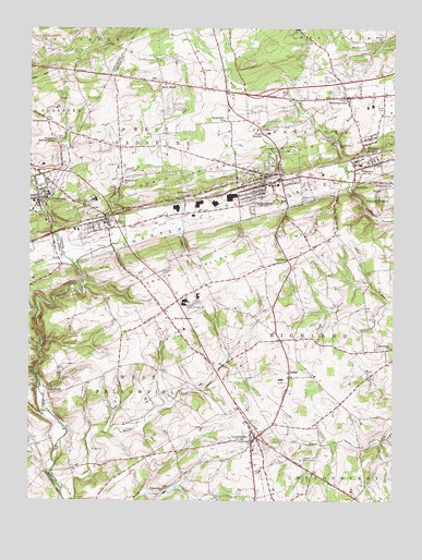
Parkesburg, PA USGS Topographic Map
Click on map above to begin viewing in our Map Viewer.

This topographic map contains these locations and features:
Feature Name Type Latitude Longitude GNIS ID View Map
Annan RunStreamN39.8982°W75.9944°1168317View Map
AtglenPopulated PlaceN39.9493°W75.9736°1168482View Map
Atglen Post OfficePost OfficeN39.9491°W75.9740°2773070View Map
Black HorsePopulated PlaceN39.9857°W75.9550°1203111View Map
Black Horse Post Office (historical)Post OfficeN39.9843°W75.9544°1214536View Map
Black Horse TavernBuildingN39.9851°W75.9544°1207397View Map
Bonsall SchoolSchoolN39.9968°W75.8791°1169984View Map
Borough of AtglenCivilN39.9473°W75.9754°1215065View Map
Borough of ChristianaCivilN39.9545°W75.9970°1215333View Map
Borough of ParkesburgCivilN39.9593°W75.9176°1215075View Map
ChristianaPopulated PlaceN39.9548°W75.9969°1192264View Map
Christiana Borough Police DepartmentBuildingN39.9548°W75.9959°2780232View Map
Christiana Community Ambulance Station 46BuildingN39.9655°W75.9931°2722325View Map
Christiana Fire Company 1 Station 5 - 2BuildingN39.9526°W75.9969°2653281View Map
Christiana Post OfficePost OfficeN39.9555°W75.9967°2772634View Map
Christiana Post Office (historical)Post OfficeN39.9548°W75.9969°1214461View Map
CochranvillePopulated PlaceN39.8918°W75.9216°1172116View Map
Cochranville Census Designated PlaceCensusN39.8905°W75.9241°2634651View Map
Cochranville Fire Company Station 27BuildingN39.8910°W75.9222°2653459View Map
Cochranville Post OfficePost OfficeN39.8941°W75.9219°2779627View Map
Friendship ChurchChurchN39.9154°W75.8755°1175263View Map
Friendship United Methodist Church CemeteryCemeteryN39.9153°W75.8750°1175262View Map
Glen RunStreamN39.9484°W75.9497°1175708View Map
Glen Run CemeteryCemeteryN39.9357°W75.9521°1209059View Map
GlennvillePopulated PlaceN39.8784°W75.9524°1203690View Map
Green Meadow FarmLocaleN39.9797°W75.9817°2725598View Map
HighlandLocaleN39.9387°W75.9108°1177021View Map
Highland Medical CenterHospitalN39.8859°W75.9063°1209061View Map
HumphreyvillePopulated PlaceN39.9596°W75.8774°1177590View Map
Keystone Valley Fire Department - Central Station 8BuildingN39.9593°W75.9185°2653049View Map
Keystone Valley Fire Department - East Station 8BuildingN39.9648°W75.8809°2653302View Map
Keystone Valley Fire Department - West Station 8BuildingN39.9488°W75.9740°2653237View Map
Knight RunStreamN39.8793°W75.9888°1192717View Map
Knott RunStreamN39.9087°W75.9972°1178617View Map
LenoverPopulated PlaceN39.9554°W75.9466°1179199View Map
Maple Grove ChurchChurchN39.9593°W75.9677°1180331View Map
Octorara Middle and High SchoolSchoolN39.9268°W75.9469°1209060View Map
Officers RunStreamN39.9432°W75.9694°1182870View Map
ParkesburgPopulated PlaceN39.9587°W75.9194°1183322View Map
Parkesburg Borough Police DepartmentBuildingN39.9591°W75.9178°2776987View Map
Parkesburg Iron Company DamDamN39.9651°W75.9141°1209038View Map
Parkesburg Post OfficePost OfficeN39.9582°W75.9145°2772899View Map
Parkesburg SchoolSchoolN39.9757°W75.9333°1183323View Map
Pine CreekStreamN39.9520°W75.9944°1183766View Map
PomeroyPopulated PlaceN39.9643°W75.8866°1184221View Map
Pomeroy Census Designated PlaceCensusN39.9639°W75.8850°2634653View Map
Pomeroy HeightsPopulated PlaceN39.9704°W75.8858°1184222View Map
Pomeroy Post OfficePost OfficeN39.9653°W75.8868°2773238View Map
Sadsbury Meeting HousePopulated PlaceN39.9709°W75.9908°1185711View Map
Sadsbury Township Police DepartmentBuildingN39.9818°W75.8875°2776959View Map
SadsburyvillePopulated PlaceN39.9818°W75.8913°1185712View Map
Sadsburyville Fire Company Station 31BuildingN39.9811°W75.8901°2652616View Map
Sadsburyville Post OfficePost OfficeN39.9822°W75.8932°2773252View Map
SimmonstownPopulated PlaceN39.9757°W75.9938°1204656View Map
SteelvillePopulated PlaceN39.9048°W75.9936°1204726View Map
StottsvillePopulated PlaceN39.9595°W75.8883°1204752View Map
Township of HighlandCivilN39.9236°W75.8960°1216161View Map
Township of SadsburyCivilN39.9788°W75.9078°1216174View Map
Township of West FallowfieldCivilN39.8986°W75.9573°1216189View Map
Township of West SadsburyCivilN39.9729°W75.9561°1216195View Map
Upper OctoraroPopulated PlaceN39.9737°W75.9211°1204858View Map
Valley CreekStreamN39.9393°W75.9869°1190294View Map
Valley RunStreamN39.9390°W75.9866°1190309View Map
West Fallowfield SchoolSchoolN39.9226°W75.9508°1191021View Map
West Fallowfield Township Police DepartmentBuildingN39.8886°W75.9224°2777264View Map
West Sadsbury Township Police DepartmentBuildingN39.9858°W75.9416°2777048View Map
Zion Hill ChurchChurchN39.9529°W75.9811°1192016View Map

Note: Coordinates in the location and feature list above are referenced to NAD83 datum.


Copyright (C) 2008-2024 Ryan Niemi / Sunset Dynamics ... All Rights Reserved