TopoQuest Logo
Do you find TopoQuest useful?
Help keep TopoQuest running and adding new maps/features by donating!
Bitcoin:  19c7KJd3qBynnjoSw5npx9KScwjBe4ifkT
Litecoin:  LXs6TkuXGGXo1vDsWCkWVdjQX94eUKd6ui
Home View Maps Find Maps Find Places Resources & Links


Philadelphia, Tennessee Topographic Map

USGS Map Title: Philadelphia, TN
USGS Map MRC: 35084F4
DRG (GeoTIFF) Download: o35084f4.tif


Neighboring USGS Topographic Map Quads:


  Bacon Gap, TN  
35084G5
 

  Cave Creek, TN  
35084G4
 

  Lenoir City, TN  
35084G3
 

  Pattie Gap, TN  
35084F5
 

  Philadelphia, TN  
35084F4
 

  Loudon, TN  
35084F3
 

  Niota, TN  
35084E5
 

  Sweetwater, TN  
35084E4
 

  Madisonville, TN  
35084E3


Map MRC Location:

N36°
W85°
N36°
W84°
H8 H7 H6 H5 H4 H3 H2 H1
G8 G7 G6 G5 G4 G3 G2 G1
F8 F7 F6 F5 F4 F3 F2 F1
E8 E7 E6 E5 E4 E3 E2 E1
D8 D7 D6 D5 D4 D3 D2 D1
C8 C7 C6 C5 C4 C3 C2 C1
B8 B7 B6 B5 B4 B3 B2 B1
A8 A7 A6 A5 A4 A3 A2 A1
N35°
W85°
N35°
W84°

Philadelphia, TN USGS 1:24K Topographic Map Preview:
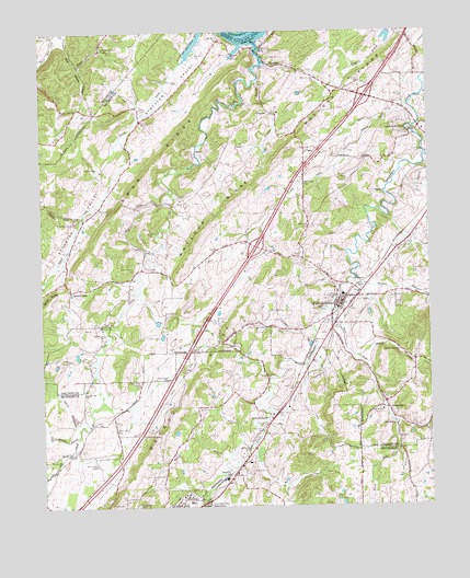
Philadelphia, TN USGS Topographic Map
Click on map above to begin viewing in our Map Viewer.

This topographic map contains these locations and features:
Feature Name Type Latitude Longitude GNIS ID View Map
AdolphusPopulated PlaceN35.7412°W84.4255°1304771View Map
Bacon CreekStreamN35.6767°W84.4063°1276067View Map
Callaway SpringSpringN35.6934°W84.3805°1279333View Map
Carter CemeteryCemeteryN35.6762°W84.4563°1279787View Map
Cedar Grove ChurchChurchN35.7456°W84.4799°1280042View Map
Cedar Valley ChurchChurchN35.6381°W84.4752°1280104View Map
Cedar Valley ChurchChurchN35.6573°W84.4688°1280105View Map
Cherry BranchStreamN35.6465°W84.4872°1280335View Map
City of PhiladelphiaCivilN35.6789°W84.3998°2404511View Map
Commissioner District 4CivilN35.6761°W84.4238°2464061View Map
Dry Valley BranchStreamN35.7306°W84.3808°1283027View Map
FairlanePopulated PlaceN35.6270°W84.4547°1283979View Map
Faith ChapelChurchN35.6784°W84.4052°1316157View Map
Fergusons Flying Circus AirportAirportN35.7138°W84.4124°1301363View Map
First Baptist ChurchChurchN35.6704°W84.4033°1316158View Map
FocheePopulated PlaceN35.7006°W84.4860°1309533View Map
Foshee ChapelChurchN35.7001°W84.4888°1284686View Map
Galyon GapGapN35.6820°W84.4908°1285111View Map
Gilman SwitchLocaleN35.6370°W84.4355°1642754View Map
Greasy BranchStreamN35.6437°W84.4891°1303462View Map
Harmon Chapel Cumberland Presbyterian ChurchChurchN35.6804°W84.4055°1316159View Map
Harris CemeteryCemeteryN35.6698°W84.4655°1286961View Map
Interchange 68CrossingN35.6934°W84.4305°1309544View Map
Interchange 72CrossingN35.7329°W84.3946°1309543View Map
Johnson CemeteryCemeteryN35.7142°W84.4813°1289551View Map
Jones CemeteryCemeteryN35.6581°W84.4863°1289724View Map
Lay CemeteryCemeteryN35.6840°W84.4538°1290822View Map
Loudon City ParkPopulated PlaceN35.7245°W84.3774°1292103View Map
Loudon County Prison Camp (historical)LocaleN35.7473°W84.4277°1309557View Map
Loudon Fire Department Station 2BuildingN35.7351°W84.4013°2654811View Map
Loudon Police Department Station 2BuildingN35.7351°W84.4013°2766080View Map
Marney CemeteryCemeteryN35.7298°W84.4674°1292718View Map
Matlock RidgeRidgeN35.7192°W84.4202°1292947View Map
McGuire MineMineN35.6381°W84.4241°1642772View Map
New Hope ChurchChurchN35.6729°W84.4808°1295534View Map
North Monroe Volunteer Fire DepartmentBuildingN35.6396°W84.4569°2654495View Map
Northpoint CemeteryCemeteryN35.6251°W84.4701°1295963View Map
Old SweetwaterPopulated PlaceN35.6479°W84.4263°1296377View Map
Old Sweetwater Baptist ChurchChurchN35.6492°W84.4260°1310125View Map
Old Sweetwater CemeteryCemeteryN35.6465°W84.4291°1317916View Map
PhiladelphiaPopulated PlaceN35.6795°W84.4038°1297307View Map
Philadelphia Division (historical)CensusN35.6904°W84.4408°1648838View Map
Philadelphia Elementary SchoolSchoolN35.6806°W84.4027°1309590View Map
Philadelphia Fire and RescueBuildingN35.6774°W84.4036°2654358View Map
Philadelphia ParkParkN35.6787°W84.3846°1309587View Map
Philadelphia Post OfficePost OfficeN35.6767°W84.4023°1649975View Map
Philadelphia United Methodist ChurchChurchN35.6795°W84.4024°1316160View Map
Pleasant RunStreamN35.6842°W84.3988°1297921View Map
Pond CreekStreamN35.7473°W84.4299°1298099View Map
Pond CreekStreamN35.6440°W84.4888°1275407View Map
Pond Creek Ferry (historical)CrossingN35.7492°W84.4313°1643307View Map
Pond Creek School (historical)SchoolN35.6870°W84.4697°1309624View Map
Preston MineMineN35.6381°W84.4291°1642788View Map
ProspectPopulated PlaceN35.7281°W84.4241°1315774View Map
Prospect Baptist ChurchChurchN35.7287°W84.4230°1643308View Map
Prospect BranchStreamN35.7373°W84.4299°1298573View Map
Prospect School (historical)SchoolN35.7290°W84.4246°1322675View Map
Rausin CreekStreamN35.6642°W84.3985°1298961View Map
Rausin SpringSpringN35.6658°W84.3850°1298962View Map
Reed SpringSpringN35.6468°W84.3869°1299155View Map
Reed Spring ChurchChurchN35.6501°W84.3905°1299157View Map
Reed Springs CemeteryCemeteryN35.6503°W84.3913°1646061View Map
Roberson CemeteryCemeteryN35.7178°W84.3788°1299599View Map
Roberson School (historical)SchoolN35.7242°W84.3796°1309601View Map
Snow RidgeRidgeN35.7167°W84.4616°1270788View Map
Snow School (historical)SchoolN35.7259°W84.4677°1309604View Map
Stockton Valley ChurchChurchN35.7265°W84.4672°1303852View Map
SunnysidePopulated PlaceN35.6523°W84.3896°1303941View Map
Sunnyside School (historical)SchoolN35.6509°W84.3885°1309605View Map
Town of LoudonCivilN35.7305°W84.3929°2406045View Map
Vida MineMineN35.6315°W84.4346°1642809View Map
Watson RidgeRidgeN35.6345°W84.4702°1304419View Map
Wilson CemeteryCemeteryN35.7431°W84.4252°1274805View Map
Zion HollowValleyN35.7485°W84.4915°1275377View Map
Zion Spring BranchStreamN35.7492°W84.4910°1310480View Map

Note: Coordinates in the location and feature list above are referenced to NAD83 datum.


Copyright (C) 2008-2024 Ryan Niemi / Sunset Dynamics ... All Rights Reserved