TopoQuest Logo
Do you find TopoQuest useful?
Help keep TopoQuest running and adding new maps/features by donating!
Bitcoin:  19c7KJd3qBynnjoSw5npx9KScwjBe4ifkT
Litecoin:  LXs6TkuXGGXo1vDsWCkWVdjQX94eUKd6ui
Home View Maps Find Maps Find Places Resources & Links


Pita Island, Texas Topographic Map

USGS Map Title: Pita Island, TX
USGS Map MRC: 27097E3
DRG (GeoTIFF) Download: o27097e3.tif


Neighboring USGS Topographic Map Quads:


  Oso Creek NW, TX  
27097F4
 

  Oso Creek NE, TX  
27097F3
 

  Crane Islands NW, TX  
27097F2
 

  Chapman Ranch, TX  
27097E4
 

  Pita Island, TX  
27097E3
 

  Crane Islands SW, TX  
27097E2
 

  South Bird Island NW, TX  
27097D4


Map MRC Location:

N28°
W98°
N28°
W97°
H8 H7 H6 H5 H4 H3 H2 H1
G8 G7 G6 G5 G4 G3 G2 G1
F8 F7 F6 F5 F4 F3 F2 F1
E8 E7 E6 E5 E4 E3 E2 E1
D8 D7 D6 D5 D4 D3 D2 D1
C8 C7 C6 C5 C4 C3 C2 C1
B8 B7 B6 B5 B4 B3 B2 B1
A8 A7 A6 A5 A4 A3 A2 A1
N27°
W98°
N27°
W97°

Pita Island, TX USGS 1:24K Topographic Map Preview:
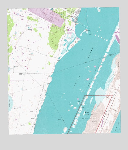
Pita Island, TX USGS Topographic Map
Click on map above to begin viewing in our Map Viewer.

This topographic map contains these locations and features:
Feature Name Type Latitude Longitude GNIS ID View Map
Acuna WindmillLocaleN27.6045°W97.3517°1329195View Map
Barney M Davis ReservoirReservoirN27.6185°W97.3307°1857303View Map
Beacrofts HoleBasinN27.5503°W97.3219°1377229View Map
Bluff Landing MarinaLocaleN27.6117°W97.2986°2030497View Map
Elgin Public LibraryBuildingN27.5414°W97.3733°2015035View Map
Emmords HoleBasinN27.5031°W97.3289°1377232View Map
Encina Sola WindmillLocaleN27.5881°W97.3205°1335451View Map
Guajolote WindmillLocaleN27.6192°W97.3472°1337085View Map
Hacha WindmillLocaleN27.5445°W97.3544°1337175View Map
Los Cedros WindmillLocaleN27.5500°W97.3319°1340580View Map
Matanza WindmillLocaleN27.5731°W97.3192°1341069View Map
Natural ChannelChannelN27.5920°W97.2919°1377239View Map
Natural GutChannelN27.5920°W97.2850°1377240View Map
New Humble ChannelChannelN27.5961°W97.2753°1377241View Map
North Bird IslandIslandN27.5209°W97.2905°1342690View Map
Nueces County Emergency Services District 2BuildingN27.6195°W97.3021°2334257View Map
Oalesby HoleBasinN27.5212°W97.3044°1377242View Map
Patos WindmillLocaleN27.5262°W97.3689°1343657View Map
Pita IslandIslandN27.6028°W97.2867°1344137View Map
Pita WindmillLocaleN27.6000°W97.3661°1344145View Map
Salada WindmillLocaleN27.5673°W97.3686°1346142View Map
Toro WindmillLocaleN27.5089°W97.3608°1348656View Map
Vina WindmillLocaleN27.5795°W97.3464°1349289View Map
Windmill Number FourLocaleN27.5411°W97.3733°1350361View Map
Yerba Anis WindmillLocaleN27.5159°W97.3467°1350684View Map

Note: Coordinates in the location and feature list above are referenced to NAD83 datum.


Copyright (C) 2008-2024 Ryan Niemi / Sunset Dynamics ... All Rights Reserved