TopoQuest Logo
Do you find TopoQuest useful?
Help keep TopoQuest running and adding new maps/features by donating!
Bitcoin:  19c7KJd3qBynnjoSw5npx9KScwjBe4ifkT
Litecoin:  LXs6TkuXGGXo1vDsWCkWVdjQX94eUKd6ui
Home View Maps Find Maps Find Places Resources & Links


Pitman West, New Jersey Topographic Map

USGS Map Title: Pitman West, NJ
USGS Map MRC: 39075F2
DRG (GeoTIFF) Download: o39075f2.tif


Neighboring USGS Topographic Map Quads:


  Bridgeport, NJ  
39075G3
 

  Woodbury, NJ  
39075G2
 

  Runnemede, NJ  
39075G1
 

  Woodstown, NJ  
39075F3
 

  Pitman West, NJ  
39075F2
 

  Pitman East, NJ  
39075F1
 

  Alloway, NJ  
39075E3
 

  Elmer, NJ  
39075E2
 

  Newfield, NJ  
39075E1


Map MRC Location:

N40°
W76°
N40°
W75°
H8 H7 H6 H5 H4 H3 H2 H1
G8 G7 G6 G5 G4 G3 G2 G1
F8 F7 F6 F5 F4 F3 F2 F1
E8 E7 E6 E5 E4 E3 E2 E1
D8 D7 D6 D5 D4 D3 D2 D1
C8 C7 C6 C5 C4 C3 C2 C1
B8 B7 B6 B5 B4 B3 B2 B1
A8 A7 A6 A5 A4 A3 A2 A1
N39°
W76°
N39°
W75°

Pitman West, NJ USGS 1:24K Topographic Map Preview:
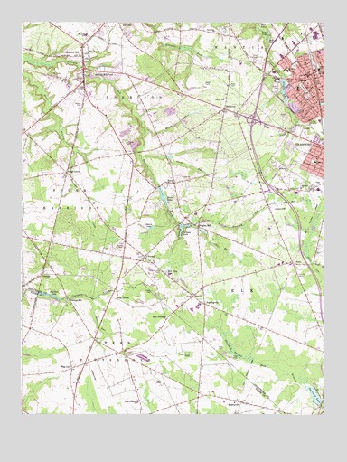
Pitman West, NJ USGS Topographic Map
Click on map above to begin viewing in our Map Viewer.

This topographic map contains these locations and features:
Feature Name Type Latitude Longitude GNIS ID View Map
Alcyon LakeReservoirN39.7321°W75.1418°874273View Map
Alcyon Lake DamDamN39.7321°W75.1418°884209View Map
Alcyon ParkParkN39.7287°W75.1452°874274View Map
Algonkin LakeReservoirN39.6631°W75.2393°874288View Map
Ambassador Christian Academy SchoolSchoolN39.7132°W75.1321°2373541View Map
AuraPopulated PlaceN39.6729°W75.1374°874427View Map
Aura Elementary SchoolSchoolN39.6735°W75.1420°2372219View Map
Aura Volunteer Fire Company No. 1BuildingN39.6714°W75.1365°2401515View Map
Avis MillsPopulated PlaceN39.6659°W75.2482°883126View Map
Barnsboro ChurchChurchN39.7471°W75.1696°874513View Map
Betty ParkParkN39.7307°W75.1405°874734View Map
Borough of PitmanCivilN39.7335°W75.1306°885354View Map
Cartwheel BranchStreamN39.6828°W75.1739°875230View Map
Cedar GrovePopulated PlaceN39.7021°W75.2307°875275View Map
Cedar LakeLakeN39.7465°W75.1482°875296View Map
Clems RunStreamN39.7075°W75.2005°875485View Map
Elephant SwampSwampN39.6454°W75.1624°876145View Map
Elk Township Police DeptBuildingN39.6730°W75.1397°2730931View Map
ElsmerePopulated PlaceN39.6965°W75.1371°882961View Map
Elsmere SchoolSchoolN39.6971°W75.1349°876177View Map
Emanuel ChurchChurchN39.6971°W75.1341°876184View Map
Emerald LakeLakeN39.7446°W75.1482°876185View Map
EwanPopulated PlaceN39.6987°W75.1860°876244View Map
Ewan LakeReservoirN39.6945°W75.1914°876245View Map
Ewan Volunteer Fire CompanyBuildingN39.6991°W75.1891°2401801View Map
Ewans Mill DamDamN39.6976°W75.1924°884207View Map
Faith ChurchChurchN39.6987°W75.1266°876290View Map
FerrellPopulated PlaceN39.6754°W75.1988°876326View Map
Ferrell Volunteer Fire Company and RescueBuildingN39.6754°W75.1999°2401796View Map
Franzens Strip (historical)AirportN39.6334°W75.2163°884526View Map
Friends School - Mullica HillSchoolN39.7316°W75.2263°2373643View Map
Fruitwood FarmsLocaleN39.6697°W75.1875°2516157View Map
Garrison LakeLakeN39.6313°W75.1290°876565View Map
Gilman LakeReservoirN39.6852°W75.1819°876614View Map
Glen LakeReservoirN39.7240°W75.1255°876625View Map
Gloucester CountyCivilN39.7173°W75.1414°882277View Map
Gloucester County Christian SchoolSchoolN39.7376°W75.1595°2373767View Map
HardingvillePopulated PlaceN39.6601°W75.1741°876944View Map
HARMONY EMSBuildingN39.7352°W75.2251°2660025View Map
Harmony Volunteer Fire DepartmentBuildingN39.7352°W75.2249°2401732View Map
Harrison Township Elementary SchoolSchoolN39.7459°W75.2237°2373582View Map
Harrison Twp Police DeptBuildingN39.7462°W75.2199°2730546View Map
Holiness CampLocaleN39.6693°W75.1360°877167View Map
Holy Name ChurchChurchN39.7409°W75.2216°877202View Map
J Harvey Rodgers SchoolSchoolN39.7056°W75.1288°879772View Map
Jessups MillPopulated PlaceN39.6618°W75.2305°877456View Map
Kettle RunStreamN39.6618°W75.2207°877554View Map
Kincaid LakeReservoirN39.7072°W75.1891°884374View Map
Kincaid Lake DamDamN39.7071°W75.1902°884208View Map
Kraemer HeliportAirportN39.7443°W75.1582°884911View Map
Laytons Airfield (historical)AirportN39.6373°W75.2196°884991View Map
LincolnPopulated PlaceN39.6696°W75.2407°877761View Map
Loggerhead PondLakeN39.6442°W75.1800°877898View Map
Marl LakesLakeN39.7478°W75.1515°878126View Map
Memorial Elementary SchoolSchoolN39.7346°W75.1401°2373585View Map
Miery RunStreamN39.7162°W75.1990°878324View Map
MonroevillePopulated PlaceN39.6290°W75.1593°878442View Map
Monroeville Volunteer Fire CompanyBuildingN39.6293°W75.1590°2401790View Map
Mount Calvary CemeteryCemeteryN39.7332°W75.2369°878519View Map
Mount Calvary ChurchChurchN39.7318°W75.2299°878524View Map
Mount Moriah ChurchChurchN39.7037°W75.1402°878563View Map
Mount Pleasant OrchardsLocaleN39.7153°W75.1708°2516162View Map
Mullica HillPopulated PlaceN39.7393°W75.2241°878657View Map
Mullica Hill Census Designated PlaceCensusN39.7267°W75.2192°2389522View Map
Mullica Hill PondReservoirN39.7331°W75.2210°878658View Map
Neale's OrchardsLocaleN39.7153°W75.1508°2516163View Map
New FreedomPopulated PlaceN39.6554°W75.1899°878735View Map
Omary LakeReservoirN39.6845°W75.1962°878992View Map
Pine TavernPopulated PlaceN39.6618°W75.2099°879316View Map
PitmanPopulated PlaceN39.7329°W75.1316°879336View Map
Pitman Country ClubLocaleN39.7393°W75.1538°884470View Map
Pitman Emergency Medicdal ServicesBuildingN39.7292°W75.1320°2660153View Map
Pitman Fire Department Station 28 - 1 Pitman Fire CompanyBuildingN39.7339°W75.1290°2401905View Map
Pitman Fire Department Station 28 - 2 Fire PatrolBuildingN39.7293°W75.1321°2401910View Map
Pitman Fire Department Station 28 - 3 Highland Chemical and Engine CompanyBuildingN39.7369°W75.1321°2401671View Map
Pitman High SchoolSchoolN39.7405°W75.1269°2373612View Map
Pitman Middle SchoolSchoolN39.7351°W75.1272°2373885View Map
Pitman Police DeptBuildingN39.7311°W75.1299°2730766View Map
Plank RunStreamN39.7181°W75.1370°879346View Map
Pleasant Valley Elementary SchoolSchoolN39.7465°W75.2096°2372716View Map
Rich Crow LakeLakeN39.6709°W75.1896°879673View Map
RichwoodPopulated PlaceN39.7226°W75.1655°879679View Map
Richwood Census Designated PlaceCensusN39.7140°W75.1734°2584022View Map
Rough Acres DamDamN39.7176°W75.1371°884210View Map
Rough Acres PondReservoirN39.7176°W75.1371°884211View Map
Saint Cyprian ChurchChurchN39.6968°W75.1305°879964View Map
Siloam ChurchChurchN39.6632°W75.1788°880595View Map
Sony Music HeliportAirportN39.7482°W75.1274°884892View Map
Summit Avenue SchoolSchoolN39.7337°W75.1277°880993View Map
Thomas Browne AirparkAirportN39.6912°W75.1433°884763View Map
Thomas E Bowe Elementary SchoolSchoolN39.7191°W75.1270°2372379View Map
Township of ElkCivilN39.6656°W75.1531°882139View Map
Township of HarrisonCivilN39.7267°W75.2074°882146View Map
Trinity ChurchChurchN39.7329°W75.2235°881251View Map
Tylers Mill PondReservoirN39.7486°W75.1524°883652View Map
Upper Pittsgrove Elementary SchoolSchoolN39.6293°W75.2016°881393View Map
W C K Walls Elementary SchoolSchoolN39.7293°W75.1360°881505View Map
Whig LanePopulated PlaceN39.6396°W75.2288°881769View Map
Wrights MillPopulated PlaceN39.6848°W75.1760°881963View Map
Wrights Mill DamDamN39.6848°W75.1768°884212View Map
Wrights MillpondReservoirN39.6867°W75.1748°883125View Map

Note: Coordinates in the location and feature list above are referenced to NAD83 datum.


Copyright (C) 2008-2024 Ryan Niemi / Sunset Dynamics ... All Rights Reserved