TopoQuest Logo
Do you find TopoQuest useful?
Help keep TopoQuest running and adding new maps/features by donating!
Bitcoin:  19c7KJd3qBynnjoSw5npx9KScwjBe4ifkT
Litecoin:  LXs6TkuXGGXo1vDsWCkWVdjQX94eUKd6ui
Home View Maps Find Maps Find Places Resources & Links


Poquoson East, Virginia Topographic Map

USGS Map Title: Poquoson East, VA
USGS Map MRC: 37076B3
DRG (GeoTIFF) Download: o37076b3.tif


Neighboring USGS Topographic Map Quads:


  Achilles, VA  
37076C4
 

  New Point Comfort, VA  
37076C3
 

  East of New Point Comfort, VA  
37076C2
 

  Poquoson West, VA  
37076B4
 

  Poquoson East, VA  
37076B3
 

  East of Poquoson East, VA  
37076B2
 

  Newport News North, VA  
37076A4
 

  Hampton, VA  
37076A3
 

  East of Hampton, VA  
37076A2


Map MRC Location:

N38°
W77°
N38°
W76°
H8 H7 H6 H5 H4 H3 H2 H1
G8 G7 G6 G5 G4 G3 G2 G1
F8 F7 F6 F5 F4 F3 F2 F1
E8 E7 E6 E5 E4 E3 E2 E1
D8 D7 D6 D5 D4 D3 D2 D1
C8 C7 C6 C5 C4 C3 C2 C1
B8 B7 B6 B5 B4 B3 B2 B1
A8 A7 A6 A5 A4 A3 A2 A1
N37°
W77°
N37°
W76°

Poquoson East, VA USGS 1:24K Topographic Map Preview:
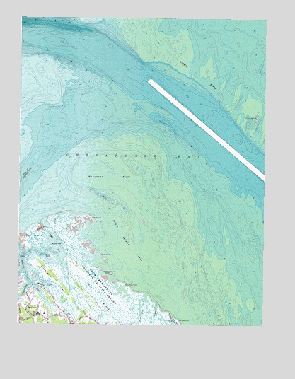
Poquoson East, VA USGS Topographic Map
Click on map above to begin viewing in our Map Viewer.

This topographic map contains these locations and features:
Feature Name Type Latitude Longitude GNIS ID View Map
Bible Baptist ChurchChurchN37.1285°W76.3644°1749875View Map
Big Salt MarshSwampN37.1319°W76.3327°1478214View Map
Blacksnake IslandIslandN37.1568°W76.3583°1478224View Map
Blackwalnut RidgeRidgeN37.1449°W76.3569°1478226View Map
City of PoquosonCivilN37.1503°W76.2706°1498436View Map
Cow IslandIslandN37.1613°W76.3680°1478432View Map
District 3CivilN37.2235°W76.3185°1927235View Map
Drum Island FlatsFlatN37.1557°W76.3172°1478503View Map
Drum PointCapeN37.1526°W76.3324°1478506View Map
Easton CoveBayN37.1407°W76.3608°1478535View Map
Fire Pine CreekLakeN37.1287°W76.3121°1478592View Map
Floyds BayBayN37.1390°W76.3719°1478605View Map
Gum Hammock CreekGutN37.1307°W76.3041°1478708View Map
Lloyd BayBayN37.1588°W76.3566°1478982View Map
Marsh IslandIslandN37.1524°W76.3708°1479044View Map
Marsh PointCapeN37.1693°W76.3388°1479046View Map
OddPopulated PlaceN37.1293°W76.3511°1749882View Map
Plum Tree Island National Wildlife RefugeParkN37.1397°W76.3286°1488804View Map
Plumtree IslandIslandN37.1253°W76.2947°1479353View Map
Plumtree PointCapeN37.1253°W76.2947°1479354View Map
Poquoson City Fire and Rescue Station 1BuildingN37.1281°W76.3610°2331717View Map
Poquoson Elementary SchoolSchoolN37.1302°W76.3609°1749885View Map
Poquoson FlatsFlatN37.1882°W76.3224°1479364View Map
Poquoson Middle SchoolSchoolN37.1291°W76.3646°1749887View Map
Rock CreekGutN37.1679°W76.3552°1479456View Map
Sandy BayBayN37.1640°W76.3624°1479543View Map
Sheep IslandIslandN37.1524°W76.3572°1479600View Map
Thorofare CreekGutN37.1257°W76.2966°1479731View Map
Ware Stick PointCapeN37.1418°W76.3208°1479820View Map
Whalebone IslandIslandN37.1454°W76.3294°1479874View Map
York CountyCivilN37.2348°W76.2905°1480182View Map
York SpitBarN37.2265°W76.2830°1474354View Map
York Spit LighthouseLocaleN37.2099°W76.2538°1474356View Map

Note: Coordinates in the location and feature list above are referenced to NAD83 datum.


Copyright (C) 2008-2024 Ryan Niemi / Sunset Dynamics ... All Rights Reserved