TopoQuest Logo
Do you find TopoQuest useful?
Help keep TopoQuest running and adding new maps/features by donating!
Bitcoin:  19c7KJd3qBynnjoSw5npx9KScwjBe4ifkT
Litecoin:  LXs6TkuXGGXo1vDsWCkWVdjQX94eUKd6ui
Home View Maps Find Maps Find Places Resources & Links


Pownal, Vermont Topographic Map

USGS Map Title: Pownal, VT
USGS Map MRC: 42073G2
DRG (GeoTIFF) Download: o42073g2.tif


Neighboring USGS Topographic Map Quads:


  Hoosick Falls, NY  
42073H3
 

  Bennington, VT  
42073H2
 

  Woodford, VT  
42073H1
 

  North Pownal, VT  
42073G3
 

  Pownal, VT  
42073G2
 

  Stamford, VT  
42073G1


Map MRC Location:

N43°
W74°
N43°
W73°
H8 H7 H6 H5 H4 H3 H2 H1
G8 G7 G6 G5 G4 G3 G2 G1
F8 F7 F6 F5 F4 F3 F2 F1
E8 E7 E6 E5 E4 E3 E2 E1
D8 D7 D6 D5 D4 D3 D2 D1
C8 C7 C6 C5 C4 C3 C2 C1
B8 B7 B6 B5 B4 B3 B2 B1
A8 A7 A6 A5 A4 A3 A2 A1
N42°
W74°
N42°
W73°

Pownal, VT USGS 1:24K Topographic Map Preview:
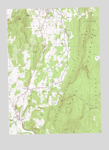
Pownal, VT USGS Topographic Map
Click on map above to begin viewing in our Map Viewer.

This topographic map contains these locations and features:
Feature Name Type Latitude Longitude GNIS ID View Map
Barber PondReservoirN42.7990°W73.1932°1460556View Map
Barber Pond DamDamN42.7990°W73.1929°1766487View Map
Barber SchoolSchoolN42.7998°W73.1843°1460557View Map
Beech Street SchoolSchoolN42.8679°W73.1743°1460596View Map
Bennington Census Designated PlaceCensusN42.8746°W73.1852°2378120View Map
Bennington HatcheryLocaleN42.8529°W73.1721°1920184View Map
Bennington Municipal ForestForestN42.8415°W73.1801°1920187View Map
Bennington Rural Fire Department Station 3BuildingN42.8708°W73.1761°2121255View Map
Bushnell CemeteryCemeteryN42.8391°W73.1869°1460687View Map
Bushnell SchoolSchoolN42.8392°W73.1748°1460688View Map
Carpenter HillSummitN42.8315°W73.2154°1460705View Map
Carpenter Hill Yard CemeteryCemeteryN42.8459°W73.2084°1920214View Map
Christian and Missionary Alliance ChurchChurchN42.8712°W73.1946°1920219View Map
Col Seth Warner CampLocaleN42.7734°W73.1393°1460741View Map
Cozy Meadow Mobile Home ParkPopulated PlaceN42.8001°W73.2201°1920226View Map
Downs Cemetery (historical)CemeteryN42.8401°W73.1804°1920237View Map
Dunn - Ell Card LotCemeteryN42.7953°W73.2121°1920239View Map
Ellis Mine HollowValleyN42.7645°W73.2443°1460845View Map
Frost HollowValleyN42.7629°W73.2423°1460890View Map
Gardner CemeteryCemeteryN42.8024°W73.2498°1457521View Map
Harmon HillSummitN42.8709°W73.1323°1460963View Map
Hidden Pasture FarmLocaleN42.7975°W73.2489°2723114View Map
Hill Top FarmLocaleN42.7853°W73.2319°2723115View Map
Holy Cross NovitiateChurchN42.8676°W73.2184°1460998View Map
Jewett BrookStreamN42.8715°W73.1832°1461025View Map
Joseph Barber Farm CemeteryCemeteryN42.7547°W73.2286°1920295View Map
Ladd BrookStreamN42.7620°W73.2387°1461052View Map
Lake HancockLakeN42.8245°W73.1288°1460959View Map
Lincoln HollowValleyN42.7745°W73.2498°1458223View Map
Mann HillSummitN42.7831°W73.2221°1461121View Map
Maple Grove SchoolSchoolN42.8290°W73.1746°1461125View Map
Mason HillSummitN42.7681°W73.2043°1461132View Map
Mount AnthonySummitN42.8637°W73.2323°1461176View Map
Oak Hill CemeteryCemeteryN42.7717°W73.2351°1461239View Map
Oak Hill SchoolSchoolN42.7684°W73.2371°1461240View Map
Park Lawn CemeteryCemeteryN42.8658°W73.1956°1461255View Map
Perry Thompson Farm CemeteryCemeteryN42.7756°W73.1915°1920372View Map
Pine Hollow CampgroundLocaleN42.7809°W73.1915°1920378View Map
Potter CemeteryCemeteryN42.8373°W73.2304°1920380View Map
PownalPopulated PlaceN42.7656°W73.2359°1461291View Map
Pownal CenterPopulated PlaceN42.7965°W73.2232°1461292View Map
Pownal Center CemeteryCemeteryN42.7956°W73.2235°1920383View Map
Pownal Center Fire StationBuildingN42.7955°W73.2227°2121508View Map
Pownal Center Town HallBuildingN42.7954°W73.2243°1920385View Map
Pownal Elementary SchoolSchoolN42.8003°W73.2180°1920386View Map
Pownal Fire Protective AssociationBuildingN42.7649°W73.2376°2121246View Map
Pownal Post OfficePost OfficeN42.7648°W73.2355°1920387View Map
Pownal Rescue SquadBuildingN42.7650°W73.2361°2578129View Map
Pownal Valley Fire Department - Central StationBuildingN42.7651°W73.2361°2121245View Map
Pownal Valley Fire Department - East StationBuildingN42.8320°W73.1671°2121252View Map
Reuben Jepson Farm CemeteryCemeteryN42.7515°W73.1968°1920518View Map
Roaring BranchStreamN42.8373°W73.1657°1461336View Map
Saint Joseph CollegeSchoolN42.8709°W73.2134°1920415View Map
Shadowbrook FarmLocaleN42.8656°W73.2112°1920429View Map
Shady Acres CampgroundLocaleN42.8117°W73.2098°1920428View Map
Sherman Yard CemeteryCemeteryN42.7670°W73.2406°1920441View Map
Solomon Wright LibraryBuildingN42.7842°W73.2048°1920445View Map
South StreamStreamN42.8715°W73.1832°1461447View Map
South Stream DamDamN42.8151°W73.1812°1766429View Map
South Stream PondReservoirN42.8121°W73.1804°1766430View Map
South Stream Waterfowl AreaParkN42.8090°W73.1807°1920452View Map
Southern Vermont CollegeSchoolN42.8678°W73.2186°2427583View Map
Southern Vermont College LibraryBuildingN42.8709°W73.2134°1920453View Map
Southwest Vermont Supervisory UnionSchoolN42.8679°W73.1745°2427543View Map
Southwestern Vermont Medical CenterHospitalN42.8739°W73.2075°1461303View Map
Southwestern Vermont Medical Center Medical LibraryBuildingN42.8745°W73.2065°1920454View Map
The DomeSummitN42.7787°W73.1701°1461528View Map
The ElbowLocaleN42.8448°W73.1371°1461530View Map
Thendara CampLocaleN42.8467°W73.1329°1461538View Map
Thompsons PondReservoirN42.7807°W73.1868°1461541View Map
Thompsons Pond Upper DamDamN42.7804°W73.1865°1766677View Map
Town of PownalCivilN42.7916°W73.2121°1462179View Map
Towsley CemeteryCemeteryN42.8128°W73.1967°1461826View Map
Union ChurchChurchN42.7951°W73.2234°1920487View Map
Varney SchoolSchoolN42.8529°W73.2037°1461562View Map
Woodward CemeteryCemeteryN42.8677°W73.1687°1920515View Map

Note: Coordinates in the location and feature list above are referenced to NAD83 datum.


Copyright (C) 2008-2024 Ryan Niemi / Sunset Dynamics ... All Rights Reserved