TopoQuest Logo
Do you find TopoQuest useful?
Help keep TopoQuest running and adding new maps/features by donating!
Bitcoin:  19c7KJd3qBynnjoSw5npx9KScwjBe4ifkT
Litecoin:  LXs6TkuXGGXo1vDsWCkWVdjQX94eUKd6ui
Home View Maps Find Maps Find Places Resources & Links


Remington, Virginia Topographic Map

USGS Map Title: Remington, VA
USGS Map MRC: 38077E7
DRG (GeoTIFF) Download: o38077e7.tif


Neighboring USGS Topographic Map Quads:


  Jeffersonton, VA  
38077F8
 

  Warrenton, VA  
38077F7
 

  Catlett, VA  
38077F6
 

  Brandy Station, VA  
38077E8
 

  Remington, VA  
38077E7
 

  Midland, VA  
38077E6
 

  Culpeper East, VA  
38077D8
 

  Germanna Bridge, VA  
38077D7
 

  Richardsville, VA  
38077D6


Map MRC Location:

N39°
W78°
N39°
W77°
H8 H7 H6 H5 H4 H3 H2 H1
G8 G7 G6 G5 G4 G3 G2 G1
F8 F7 F6 F5 F4 F3 F2 F1
E8 E7 E6 E5 E4 E3 E2 E1
D8 D7 D6 D5 D4 D3 D2 D1
C8 C7 C6 C5 C4 C3 C2 C1
B8 B7 B6 B5 B4 B3 B2 B1
A8 A7 A6 A5 A4 A3 A2 A1
N38°
W78°
N38°
W77°

Remington, VA USGS 1:24K Topographic Map Preview:
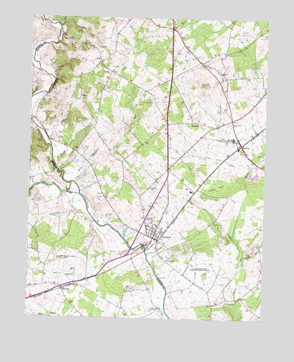
Remington, VA USGS Topographic Map
Click on map above to begin viewing in our Map Viewer.

This topographic map contains these locations and features:
Feature Name Type Latitude Longitude GNIS ID View Map
Aviacres AirportAirportN38.6243°W77.7857°1498839View Map
Beales BranchStreamN38.5660°W77.8625°1462861View Map
BealetonPopulated PlaceN38.5718°W77.7639°1499100View Map
Bealeton Census Designated PlaceCensusN38.5821°W77.7781°2584804View Map
Bealeton Post OfficePost OfficeN38.5764°W77.7626°1749228View Map
Bealeton Presbyterian ChurchChurchN38.5740°W77.7669°1749229View Map
Bealeton Village Shopping CenterLocaleN38.5821°W77.7658°1749230View Map
Bealton Baptist ChurchChurchN38.5743°W77.7653°1749227View Map
BothaPopulated PlaceN38.6068°W77.8378°1477132View Map
Bowens RunStreamN38.5668°W77.7717°1463707View Map
Brandy Station Battlefield ParkParkN38.5304°W77.8605°1988706View Map
Browns RunStreamN38.5237°W77.7611°1463932View Map
CarolandvillePopulated PlaceN38.5096°W77.7978°1749239View Map
Cedar Grove CemeteryCemeteryN38.5812°W77.7684°1464609View Map
Cedar Lee Middle SchoolSchoolN38.5755°W77.7672°1464634View Map
Cornerstone Christian AcademySchoolN38.5352°W77.8079°2465141View Map
Covingtons CornerPopulated PlaceN38.6001°W77.8003°1749243View Map
Craig RunStreamN38.5637°W77.7583°1465399View Map
Crossroads Community ChurchChurchN38.5385°W77.8065°2559650View Map
Culpeper Regional AirportAirportN38.5268°W77.8609°1498648View Map
DoddstownPopulated PlaceN38.5946°W77.8139°1749249View Map
ElkwoodPopulated PlaceN38.5118°W77.8558°1466241View Map
Elkwood Post OfficePost OfficeN38.5139°W77.8515°1499026View Map
FayettesvillePopulated PlaceN38.6140°W77.7942°1749253View Map
Grace Miller Elementary SchoolSchoolN38.5870°W77.7627°1749268View Map
Great RunStreamN38.6210°W77.8594°1467449View Map
Hazel RiverStreamN38.5512°W77.8480°1467875View Map
Hollywood CemeteryCemeteryN38.5542°W77.8107°1468167View Map
Hubbard RunStreamN38.5287°W77.8203°1468340View Map
John Barton Payne High School (historical)SchoolN38.5385°W77.8064°2061573View Map
Lee DistrictCivilN38.5222°W77.7644°1927373View Map
LibertyPopulated PlaceN38.6001°W77.7717°1749282View Map
Liberty ChurchChurchN38.6023°W77.7736°1469370View Map
Liberty High SchoolSchoolN38.5893°W77.7655°1984539View Map
LitchfieldPopulated PlaceN38.5693°W77.8322°1749283View Map
Litchfield Presbyterian ChurchChurchN38.6021°W77.8333°1469454View Map
Litchfield School (historical)SchoolN38.5982°W77.8347°1749284View Map
Lucky HillSummitN38.5615°W77.7855°1499690View Map
Mandleys CornerPopulated PlaceN38.5626°W77.8005°1749285View Map
Margaret M Pierce Elementary SchoolSchoolN38.5388°W77.8068°1472132View Map
Marsh Run Mobile Home ParkPopulated PlaceN38.5618°W77.7564°1749287View Map
Merry RunStreamN38.5568°W77.8508°1470375View Map
Oak ShadePopulated PlaceN38.5815°W77.7889°1477587View Map
OpalPopulated PlaceN38.6210°W77.8000°1499824View Map
Opal Census Designated PlaceCensusN38.6201°W77.8049°2584897View Map
PerrowvillePopulated PlaceN38.5404°W77.8092°1749306View Map
Piney Ridge School (historical)SchoolN38.5276°W77.7864°1749310View Map
Providence ChurchChurchN38.5243°W77.8014°1472837View Map
RemingtonPopulated PlaceN38.5337°W77.8083°1499948View Map
Remington CemeteryCemeteryN38.5420°W77.8140°1749307View Map
Remington Police DepartmentBuildingN38.5336°W77.8076°2767129View Map
Remington Post OfficePost OfficeN38.5367°W77.8065°1749314View Map
Remington United Methodist ChurchChurchN38.5379°W77.8083°1749315View Map
Remington Volunteer Fire and Rescue Department Fire Company 2 Rescue Company 14BuildingN38.5342°W77.8064°2075393View Map
Ruffans RunStreamN38.5407°W77.8400°1473619View Map
Rular AirportAirportN38.5385°W77.8265°2675619View Map
Saint James Baptist Church CemeteryCemeteryN38.5904°W77.8109°1749319View Map
Saint James ChurchChurchN38.5898°W77.8097°1473746View Map
Saint Lukes Episcopal ChurchChurchN38.5371°W77.8089°1749320View Map
Stony BranchStreamN38.6110°W77.8731°1475202View Map
Sunny KnollPopulated PlaceN38.5812°W77.8028°1749326View Map
The Bealeton LibraryBuildingN38.5807°W77.7661°2043109View Map
Thorn DamDamN38.5401°W77.8214°1489729View Map
Thorn PondReservoirN38.5401°W77.8214°1489730View Map
Tinpot RunStreamN38.5271°W77.8117°1475735View Map
Town of RemingtonCivilN38.5347°W77.8082°2391384View Map
WeavervillePopulated PlaceN38.5846°W77.7900°1749332View Map
Woodward Turf FarmsLocaleN38.5072°W77.8147°2676063View Map

Note: Coordinates in the location and feature list above are referenced to NAD83 datum.


Copyright (C) 2008-2024 Ryan Niemi / Sunset Dynamics ... All Rights Reserved