TopoQuest Logo
Do you find TopoQuest useful?
Help keep TopoQuest running and adding new maps/features by donating!
Bitcoin:  19c7KJd3qBynnjoSw5npx9KScwjBe4ifkT
Litecoin:  LXs6TkuXGGXo1vDsWCkWVdjQX94eUKd6ui
Home View Maps Find Maps Find Places Resources & Links


Rend Lake Dam, Illinois Topographic Map

USGS Map Title: Rend Lake Dam, IL
USGS Map MRC: 38088A8
DRG (GeoTIFF) Download: o38088a8.tif


Neighboring USGS Topographic Map Quads:


  Waltonville, IL  
38089B1
 

  Ina, IL  
38088B8
 

  Spring Garden, IL  
38088B7
 

  Sesser, IL  
38089A1
 

  Rend Lake Dam, IL  
38088A8
 

  Ewing, IL  
38088A7
 

  Christopher, IL  
37089H1
 

  West Frankfort, IL  
37088H8
 

  Thompsonville, IL  
37088H7


Map MRC Location:

N39°
W89°
N39°
W88°
H8 H7 H6 H5 H4 H3 H2 H1
G8 G7 G6 G5 G4 G3 G2 G1
F8 F7 F6 F5 F4 F3 F2 F1
E8 E7 E6 E5 E4 E3 E2 E1
D8 D7 D6 D5 D4 D3 D2 D1
C8 C7 C6 C5 C4 C3 C2 C1
B8 B7 B6 B5 B4 B3 B2 B1
A8 A7 A6 A5 A4 A3 A2 A1
N38°
W89°
N38°
W88°

Rend Lake Dam, IL USGS 1:24K Topographic Map Preview:
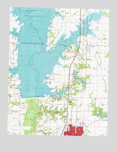
Rend Lake Dam, IL USGS Topographic Map
Click on map above to begin viewing in our Map Viewer.

This topographic map contains these locations and features:
Feature Name Type Latitude Longitude GNIS ID View Map
Airport Industrial ParkLocaleN38.0106°W88.9431°1810914View Map
Barren TownhallBuildingN38.0892°W88.9945°1725555View Map
Benton Country ClubLocaleN38.0184°W88.8820°424627View Map
Benton Lookout TowerTowerN38.0337°W88.9220°424628View Map
Benton Municipal AirportAirportN38.0057°W88.9334°427064View Map
Benton North Oil FieldOilfieldN38.0434°W88.9387°424629View Map
Benton ParkPopulated PlaceN38.0598°W88.9148°425689View Map
Bluebell BluffCliffN38.0228°W88.9390°404610View Map
Browning CemeteryCemeteryN38.0167°W88.9384°404969View Map
Browning CemeteryCemeteryN38.0225°W88.9898°404970View Map
Browning HillSummitN38.0226°W88.9906°404974View Map
Casey ForkStreamN38.0909°W88.9567°424538View Map
Church of GodChurchN38.0003°W88.9101°1876007View Map
City of BentonCivilN38.0110°W88.9178°2394140View Map
Conner College (historical)SchoolN38.0784°W88.9301°1705629View Map
Cypher CemeteryCemeteryN38.0812°W88.9062°406916View Map
Drummond CemeteryCemeteryN38.0209°W88.8895°407402View Map
Fallet BranchStreamN38.0045°W88.9667°408254View Map
First Free Will Baptist ChurchChurchN38.0081°W88.9062°1876021View Map
Flatts SchoolSchoolN38.0159°W88.9470°408448View Map
Franklin CemeteryCemeteryN38.0673°W88.9295°408659View Map
Franklin County FairgroundParkN38.0114°W88.9078°1725574View Map
Franklin HospitalHospitalN38.0100°W88.9182°408667View Map
Grant Elementary SchoolSchoolN38.0064°W88.9103°409296View Map
Gun CreekStreamN38.0809°W88.9617°409567View Map
Gun Creek Public Use AreaParkN38.0820°W88.9306°409568View Map
Hamilton BranchStreamN38.1012°W88.8962°409690View Map
Hazel Dell Free Will Baptist ChurchChurchN38.0787°W88.9948°409975View Map
Hazel Dell School (historical)SchoolN38.0834°W88.9942°1705632View Map
Immanuel Baptist ChurchChurchN38.0034°W88.9198°1876023View Map
Interchange 77CrossingN38.0806°W88.9156°1810960View Map
Jackie BranchStreamN38.0973°W88.9887°410995View Map
King College (historical)SchoolN38.1037°W88.9403°1705635View Map
Lake BentonReservoirN38.0554°W88.9144°404195View Map
Lake Benton CampLocaleN38.0481°W88.9048°411701View Map
Lake Benton DamDamN38.0550°W88.9165°1690955View Map
Lake HamiltonReservoirN38.0532°W88.9065°409703View Map
Lake Hamilton DamDamN38.0525°W88.9059°1690953View Map
Lincoln SchoolSchoolN38.0000°W88.9256°412144View Map
Marcum BranchStreamN38.0456°W88.9267°412990View Map
Marcum Branch North Public Use AreaParkN38.0570°W88.9512°412991View Map
Marcum Branch South Public Use AreaParkN38.0375°W88.9362°412992View Map
McGuire School (historical)SchoolN38.0270°W88.9290°1705638View Map
Mercy Regional Health SystemBuildingN38.0099°W88.9171°2673812View Map
Meyers School (historical)SchoolN38.0056°W88.8773°1705639View Map
Mine Number 21 ReservoirReservoirN38.1096°W88.9626°1692184View Map
Moore Hospital (historical)HospitalN38.0025°W88.9212°1876012View Map
Moser CemeteryCemeteryN38.0189°W88.9523°413877View Map
North Benton Missionary Baptist ChurchChurchN38.0025°W88.9115°1876013View Map
Old Ben Number 24 MineMineN38.0184°W88.9501°425267View Map
Palestine ChurchChurchN38.0714°W88.9198°415305View Map
Palestine School (historical)SchoolN38.0523°W88.9451°1705642View Map
Rend CityPopulated PlaceN38.0270°W88.9848°416523View Map
Rend LakeReservoirN38.1096°W88.9626°416524View Map
Rend Lake Conservancy District HeliportAirportN38.0820°W88.9170°427066View Map
Rend Lake DamDamN38.0367°W88.9667°416527View Map
Rend Lake Dam West Public Use AreaParkN38.0445°W88.9867°416528View Map
Rend Lake MarinaLocaleN38.0448°W88.9853°1810966View Map
Rescue ChurchChurchN38.1039°W88.8923°416542View Map
Rollinson School (historical)SchoolN38.0245°W88.8951°1705643View Map
Salem ChurchChurchN38.0267°W88.9290°417866View Map
Sandusky CreekStreamN38.0648°W88.9878°417983View Map
Sandusky Creek North Public Use AreaParkN38.0653°W88.9970°417984View Map
Sandusky Creek South Public Use AreaParkN38.0584°W88.9912°417985View Map
Sesser Fire Protection District Station 2BuildingN38.0668°W88.9310°2640794View Map
Sesser Public Use AreaParkN38.0964°W88.9956°418225View Map
Shiloh CemeteryCemeteryN38.0714°W88.8881°418397View Map
Shiloh Church (historical)ChurchN38.0712°W88.8892°1725592View Map
Shiloh School (historical)SchoolN38.0556°W88.8756°1705644View Map
Spillway Public Use AreaParkN38.0309°W88.9603°1725596View Map
Sugar CreekStreamN38.0284°W88.9595°419261View Map
Township of BarrenCivilN38.0814°W88.9851°428637View Map
Wayman CemeteryCemeteryN38.0303°W88.9340°420661View Map
Wayne Fitzgerrell State ParkParkN38.1062°W88.9384°420663View Map
Westminister Presbyterian ChurchChurchN38.0050°W88.9287°1876027View Map
Whispering Pines Group CampLocaleN38.0384°W88.9376°1810987View Map
WhittingtonPopulated PlaceN38.0892°W88.9028°421122View Map
Whittington Oil FieldOilfieldN38.0659°W88.9034°425638View Map
Whittington Post OfficePost OfficeN38.0873°W88.9027°2788267View Map
Winemiller CemeteryCemeteryN38.0839°W88.9028°421322View Map

Note: Coordinates in the location and feature list above are referenced to NAD83 datum.


Copyright (C) 2008-2024 Ryan Niemi / Sunset Dynamics ... All Rights Reserved