TopoQuest Logo
Do you find TopoQuest useful?
Help keep TopoQuest running and adding new maps/features by donating!
Bitcoin:  19c7KJd3qBynnjoSw5npx9KScwjBe4ifkT
Litecoin:  LXs6TkuXGGXo1vDsWCkWVdjQX94eUKd6ui
Home View Maps Find Maps Find Places Resources & Links


Riceville, Tennessee Topographic Map

USGS Map Title: Riceville, TN
USGS Map MRC: 35084D6
DRG (GeoTIFF) Download: o35084d6.tif


Neighboring USGS Topographic Map Quads:


  Decatur, TN  
35084E7
 

  Tranquillity, TN  
35084E6
 

  Niota, TN  
35084E5
 

  Goodfield, TN  
35084D7
 

  Riceville, TN  
35084D6
 

  Athens, TN  
35084D5
 

  Charleston, TN  
35084C7
 

  Calhoun, TN  
35084C6
 

  Etowah, TN  
35084C5


Map MRC Location:

N36°
W85°
N36°
W84°
H8 H7 H6 H5 H4 H3 H2 H1
G8 G7 G6 G5 G4 G3 G2 G1
F8 F7 F6 F5 F4 F3 F2 F1
E8 E7 E6 E5 E4 E3 E2 E1
D8 D7 D6 D5 D4 D3 D2 D1
C8 C7 C6 C5 C4 C3 C2 C1
B8 B7 B6 B5 B4 B3 B2 B1
A8 A7 A6 A5 A4 A3 A2 A1
N35°
W85°
N35°
W84°

Riceville, TN USGS 1:24K Topographic Map Preview:
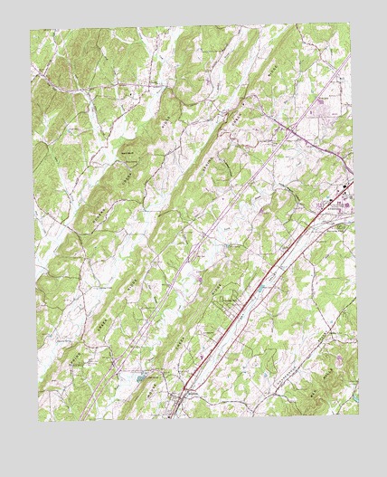
Riceville, TN USGS Topographic Map
Click on map above to begin viewing in our Map Viewer.

This topographic map contains these locations and features:
Feature Name Type Latitude Longitude GNIS ID View Map
Andrews ChapelChurchN35.3837°W84.6560°1647796View Map
Bell SpringSpringN35.3887°W84.7073°1305083View Map
Blazer LakeReservoirN35.4160°W84.6621°1277676View Map
Blue Spring BranchStreamN35.4604°W84.6463°1277794View Map
Boyd BranchStreamN35.4084°W84.7011°1278097View Map
Camp Ground School (historical)SchoolN35.4242°W84.7022°1307516View Map
Cate SpringSpringN35.4298°W84.6737°1279879View Map
Chilohowee Rod and Gun Club DamDamN35.3789°W84.6254°1301783View Map
Chilohowee Rod and Gun Club LakeReservoirN35.3799°W84.6261°1301782View Map
Clay Hill ChurchChurchN35.3859°W84.6252°1305945View Map
Clay Hill School (historical)SchoolN35.3854°W84.6255°1647802View Map
CoilePopulated PlaceN35.4281°W84.6516°1280876View Map
Commissioner District 1CivilN35.4322°W84.7432°2464259View Map
Davis CemeteryCemeteryN35.3937°W84.7297°1282139View Map
Dennis CemeteryCemeteryN35.4556°W84.7258°1282338View Map
Emmanuel ChurchChurchN35.4454°W84.6294°1283756View Map
First Baptist ChurchChurchN35.3801°W84.6966°1648009View Map
GeorgetownPopulated PlaceN35.4020°W84.6885°1315108View Map
Hilltop CemeteryCemeteryN35.3901°W84.6913°1956198View Map
Hilltop ChurchChurchN35.3901°W84.6916°1287849View Map
Hopewell BranchStreamN35.4417°W84.6694°1307528View Map
Hopewell HollowValleyN35.4486°W84.6724°1288322View Map
Horton CemeteryCemeteryN35.4251°W84.7041°1288462View Map
IdlewildPopulated PlaceN35.4812°W84.7038°1288903View Map
Idlewild Baptist ChurchChurchN35.4798°W84.7102°1320143View Map
Idlewild CemeteryCemeteryN35.4798°W84.7113°1956199View Map
Idlewild Elementary SchoolSchoolN35.4787°W84.7111°1307529View Map
Interchange 42CrossingN35.3920°W84.7191°1307531View Map
Interchange 49CrossingN35.4659°W84.6485°1307532View Map
Kinzalow SpringSpringN35.4005°W84.7362°1290276View Map
Lakeview ChurchChurchN35.4667°W84.6516°1290522View Map
Left Fork Rock CreekStreamN35.4801°W84.7299°1269718View Map
McMahan ChurchChurchN35.4770°W84.6294°1293412View Map
McMahan Church CemeteryCemeteryN35.4773°W84.6297°1956200View Map
McMinn County District 7 Idlewild Rural Fire DepartmentBuildingN35.4777°W84.7102°2654594View Map
Meadow BranchStreamN35.4667°W84.6791°1293488View Map
Mine Road LandfillLocaleN35.4856°W84.6839°2677801View Map
Mount Lebanon School (historical)SchoolN35.4134°W84.7361°1307549View Map
Mount Zion Church (historical)ChurchN35.3979°W84.7277°1307550View Map
Mouse Creek Mill (historical)LocaleN35.4731°W84.6272°1307551View Map
Mouse Creek School (historical)SchoolN35.4620°W84.6602°1307552View Map
Mud Lick BranchStreamN35.4656°W84.7152°1295016View Map
Nagle LakeReservoirN35.4674°W84.7356°1295201View Map
New Hopewell ChurchChurchN35.4504°W84.6733°1295578View Map
Oak Grove Baptist ChurchChurchN35.4270°W84.7305°1296085View Map
Oak Grove Baptist Church CemeteryCemeteryN35.4265°W84.7297°1956205View Map
Peck SpringSpringN35.3933°W84.7321°1297097View Map
Pickwatina PlacePopulated PlaceN35.4345°W84.6310°1297403View Map
Pine Hill School (historical)SchoolN35.4473°W84.7491°1307556View Map
Poplar HillPopulated PlaceN35.4023°W84.6352°1646914View Map
Poplar Hill SchoolSchoolN35.4012°W84.6360°1298205View Map
Possum CreekStreamN35.4887°W84.6983°1298293View Map
Red HillsSummitN35.3829°W84.6408°1299068View Map
RicevillePopulated PlaceN35.3848°W84.6930°1299303View Map
Riceville CemeteryCemeteryN35.3817°W84.6980°1956207View Map
Riceville Census Designated PlaceCensusN35.3895°W84.6989°2586078View Map
Riceville Elementary SchoolSchoolN35.3945°W84.6858°1307561View Map
Riceville Post OfficePost OfficeN35.3821°W84.6949°1649320View Map
Riceville United Methodist ChurchChurchN35.3792°W84.6966°1648010View Map
Roberts CemeteryCemeteryN35.4106°W84.6697°1299621View Map
Rock CreekStreamN35.4567°W84.7199°1299751View Map
Rocky Mount ChurchChurchN35.4412°W84.6447°1299915View Map
Rocky Mount HollowValleyN35.4490°W84.6555°1299916View Map
Rocky Mount School (historical)SchoolN35.4415°W84.6469°1647814View Map
Rogers Creek RidgeRidgeN35.4234°W84.7408°1300011View Map
Rose Hill ChurchChurchN35.3976°W84.6360°1307567View Map
Russell School (historical)SchoolN35.4742°W84.6266°1307568View Map
Shoal CreekStreamN35.4309°W84.7405°1270140View Map
Sokey CreekStreamN35.4409°W84.7336°1270800View Map
Spring CreekPopulated PlaceN35.4179°W84.7252°1314322View Map
Spring Creek ChurchChurchN35.4154°W84.7305°1307578View Map
Spring Creek RidgeRidgeN35.4454°W84.6938°1271100View Map
State AreaSchoolN35.4417°W84.6283°1326652View Map
Suburban HillsPopulated PlaceN35.4106°W84.6774°1271627View Map
Sullins CemeteryCemeteryN35.4392°W84.6274°1271744View Map
Thorn Hill CemeteryCemeteryN35.3831°W84.6499°1272562View Map
Underwood BranchStreamN35.4226°W84.6880°1273164View Map
Union Chapel United Methodist ChurchChurchN35.4345°W84.6924°1273192View Map
Union Chapel United Methodist Church CemeteryCemeteryN35.4348°W84.6922°1956325View Map
Wall Hollow BranchStreamN35.3862°W84.7174°1273659View Map
Walnut Grove Church (historical)ChurchN35.3756°W84.7241°1307581View Map
Ward BluffCliffN35.4601°W84.7155°1273771View Map
Ward SpringSpringN35.4569°W84.7138°1273795View Map
Webb LakeReservoirN35.4750°W84.6374°1274036View Map
Westview ChurchChurchN35.4306°W84.6402°1304498View Map
William Browder DamDamN35.3934°W84.6333°1301797View Map
William Browder LakeReservoirN35.3933°W84.6320°1301798View Map

Note: Coordinates in the location and feature list above are referenced to NAD83 datum.


Copyright (C) 2008-2024 Ryan Niemi / Sunset Dynamics ... All Rights Reserved