TopoQuest Logo
Do you find TopoQuest useful?
Help keep TopoQuest running and adding new maps/features by donating!
Bitcoin:  19c7KJd3qBynnjoSw5npx9KScwjBe4ifkT
Litecoin:  LXs6TkuXGGXo1vDsWCkWVdjQX94eUKd6ui
Home View Maps Find Maps Find Places Resources & Links


Richards, Missouri Topographic Map

USGS Map Title: Richards, MO
USGS Map MRC: 37094H5
DRG (GeoTIFF) Download: o37094h5.tif


Neighboring USGS Topographic Map Quads:


  Prescott, KS  
38094A6
 

  Hume, MO  
38094A5
 

  Sprague, MO  
38094A4
 

  Hammond, KS  
37094H6
 

  Richards, MO  
37094H5
 

  Metz, MO  
37094H4
 

  Fort Scott, KS  
37094G6
 

  Deerfield, MO  
37094G5
 

  Moundville, MO  
37094G4


Map MRC Location:

N38°
W95°
N38°
W94°
H8 H7 H6 H5 H4 H3 H2 H1
G8 G7 G6 G5 G4 G3 G2 G1
F8 F7 F6 F5 F4 F3 F2 F1
E8 E7 E6 E5 E4 E3 E2 E1
D8 D7 D6 D5 D4 D3 D2 D1
C8 C7 C6 C5 C4 C3 C2 C1
B8 B7 B6 B5 B4 B3 B2 B1
A8 A7 A6 A5 A4 A3 A2 A1
N37°
W95°
N37°
W94°

Richards, MO USGS 1:24K Topographic Map Preview:
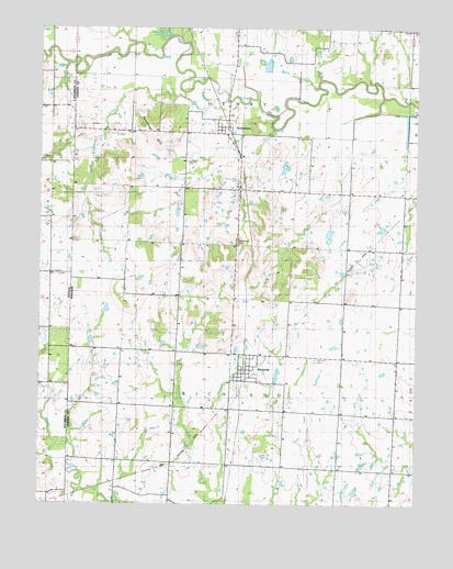
Richards, MO USGS Topographic Map
Click on map above to begin viewing in our Map Viewer.

This topographic map contains these locations and features:
Feature Name Type Latitude Longitude GNIS ID View Map
Bitterroot CreekStreamN37.9834°W94.5669°714280View Map
Coleman CemeteryCemeteryN37.8783°W94.6121°2572629View Map
Duncan CreekStreamN37.9967°W94.5841°717180View Map
East Liberty CemeteryCemeteryN37.9600°W94.5594°717318View Map
Enoch School (historical)SchoolN37.8861°W94.5827°729882View Map
Fred Wilmot DamDamN37.9550°W94.5136°763211View Map
Fred Wilmot ReservoirReservoirN37.9556°W94.5134°763212View Map
Hickman HillSummitN37.9442°W94.5594°719428View Map
Jantz DamDamN37.9167°W94.6086°763209View Map
Jantz ReservoirReservoirN37.9167°W94.6086°763210View Map
Kaufman CemeteryCemeteryN37.9650°W94.5769°758425View Map
McGinnis School (historical)SchoolN37.8767°W94.5261°748408View Map
Mononame 308 DamDamN37.9250°W94.6019°763118View Map
Osage PlainsAreaN37.9997°W94.6083°737830View Map
Pecan CreekStreamN37.9850°W94.5330°724161View Map
RichardsPopulated PlaceN37.9073°W94.5572°725254View Map
Richards Post OfficePost OfficeN37.9099°W94.5563°2782814View Map
Richards Rural Fire DepartmentBuildingN37.9095°W94.5565°2620912View Map
Richards School (historical)SchoolN37.9141°W94.5554°746139View Map
Richland CemeteryCemeteryN37.9132°W94.5335°725268View Map
Rombaugh HillsRangeN37.9709°W94.5894°725545View Map
StotesburyPopulated PlaceN37.9720°W94.5636°729970View Map
Stotesbury School (historical)SchoolN37.9742°W94.5672°746166View Map
Town of RichardsCivilN37.9104°W94.5573°2396877View Map
Town of StotesburyCivilN37.9744°W94.5645°2397684View Map
Township of RichlandCivilN37.8999°W94.5611°767494View Map
Turley CemeteryCemeteryN37.9523°W94.5452°727889View Map
Wilmot and Steele Incorporated Lake DamDamN37.9484°W94.5286°763119View Map
Wolf CreekStreamN37.9864°W94.5319°729047View Map

Note: Coordinates in the location and feature list above are referenced to NAD83 datum.


Copyright (C) 2008-2024 Ryan Niemi / Sunset Dynamics ... All Rights Reserved