TopoQuest Logo
Do you find TopoQuest useful?
Help keep TopoQuest running and adding new maps/features by donating!
Bitcoin:  19c7KJd3qBynnjoSw5npx9KScwjBe4ifkT
Litecoin:  LXs6TkuXGGXo1vDsWCkWVdjQX94eUKd6ui
Home View Maps Find Maps Find Places Resources & Links


Rodney, Ohio Topographic Map

USGS Map Title: Rodney, OH
USGS Map MRC: 38082G3
DRG (GeoTIFF) Download: o38082g3.tif


Neighboring USGS Topographic Map Quads:


  Rio Grande, OH  
38082H4
 

  Vinton, OH  
38082H3
 

  Addison, OH  
38082H2
 

  Patriot, OH  
38082G4
 

  Rodney, OH  
38082G3
 

  Gallipolis, OH  
38082G2
 

  Waterloo, OH  
38082F4
 

  Mercerville, OH  
38082F3
 

  Apple Grove, WV  
38082F2


Map MRC Location:

N39°
W83°
N39°
W82°
H8 H7 H6 H5 H4 H3 H2 H1
G8 G7 G6 G5 G4 G3 G2 G1
F8 F7 F6 F5 F4 F3 F2 F1
E8 E7 E6 E5 E4 E3 E2 E1
D8 D7 D6 D5 D4 D3 D2 D1
C8 C7 C6 C5 C4 C3 C2 C1
B8 B7 B6 B5 B4 B3 B2 B1
A8 A7 A6 A5 A4 A3 A2 A1
N38°
W83°
N38°
W82°

Rodney, OH USGS 1:24K Topographic Map Preview:
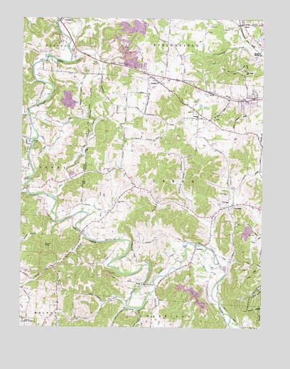
Rodney, OH USGS Topographic Map
Click on map above to begin viewing in our Map Viewer.

This topographic map contains these locations and features:
Feature Name Type Latitude Longitude GNIS ID View Map
Adamsville CemeteryCemeteryN38.8716°W82.3579°1964033View Map
Alexander ChurchChurchN38.8009°W82.3246°1075249View Map
Asbury CemeteryCemeteryN38.7676°W82.3121°1964034View Map
Asbury ChurchChurchN38.7679°W82.3124°1075282View Map
Beaver CreekStreamN38.8354°W82.3710°1075334View Map
Blancs SidingLocaleN38.8612°W82.2518°1075401View Map
Blessing BridgeBridgeN38.7673°W82.3113°1075403View Map
Buck RidgeRidgeN38.8540°W82.2638°1075467View Map
Buck Ridge CemeteryCemeteryN38.8542°W82.2585°1964040View Map
CentenaryPopulated PlaceN38.7992°W82.2676°1075547View Map
Centenary CemeteryCemeteryN38.8042°W82.2674°1075548View Map
Centenary Methodist ChurchChurchN38.7995°W82.2643°1068751View Map
Claylick RunStreamN38.7631°W82.3071°1075584View Map
Clear ForkStreamN38.7809°W82.2746°1075587View Map
CoraPopulated PlaceN38.8245°W82.3696°1075631View Map
Cora Covered BridgeBridgeN38.8251°W82.3693°1068760View Map
Cora Methodist ChurchChurchN38.8265°W82.3724°1068761View Map
Cora Mill (historical)LocaleN38.8248°W82.3693°1068762View Map
Cora Post Office (historical)Post OfficeN38.8251°W82.3693°1987920View Map
Deer Hollow TrailTrailN38.7931°W82.3618°1698889View Map
Fairfield AcresPopulated PlaceN38.8251°W82.2757°1698899View Map
Fairfield Church CemeteryCemeteryN38.8348°W82.2829°1964046View Map
Fairfield Methodist ChurchChurchN38.8351°W82.2832°1075822View Map
FairviewPopulated PlaceN38.8440°W82.2571°1698900View Map
Fork CreekStreamN38.8042°W82.3713°1075868View Map
Fox BranchStreamN38.7573°W82.3138°1075869View Map
Gallia CountyCivilN38.8247°W82.3169°1074039View Map
Garners Ford BridgeBridgeN38.8590°W82.3621°1075895View Map
Green Elementary SchoolSchoolN38.8009°W82.2682°1081382View Map
Hideaway AcresPopulated PlaceN38.8209°W82.3182°1698976View Map
Hulbert CemeteryCemeteryN38.8134°W82.3285°1076089View Map
KerrPopulated PlaceN38.8729°W82.2607°1076172View Map
Kerr Post OfficePost OfficeN38.8723°W82.2610°1987890View Map
Kriner RidgeRidgeN38.7579°W82.2532°1076195View Map
Laurel CreekStreamN38.8359°W82.3704°1076209View Map
Liddy HollowValleyN38.7987°W82.2868°1076250View Map
Life AmbulanceBuildingN38.8427°W82.2668°2550990View Map
Little Claylick RunStreamN38.7509°W82.3021°1076258View Map
Lowvy CemeteryCemeteryN38.8137°W82.3276°1964057View Map
McCormick (historical)Populated PlaceN38.8334°W82.3582°1067561View Map
McCormick Post Office (historical)Post OfficeN38.8334°W82.3582°1988258View Map
Morton FlatsPopulated PlaceN38.8290°W82.2638°1698923View Map
Mud CreekStreamN38.8023°W82.3568°1076477View Map
Natural Gorge TrailTrailN38.7909°W82.3568°1698926View Map
NorthupPopulated PlaceN38.7820°W82.2838°1076527View Map
Northup Baptist ChurchChurchN38.7812°W82.2846°1068785View Map
Northup post officePost OfficeN38.7820°W82.2832°1987891View Map
Ouster CemeteryCemeteryN38.7826°W82.2899°1076583View Map
Park Lane SubdivisionPopulated PlaceN38.8390°W82.2604°1698930View Map
Perry SchoolSchoolN38.8098°W82.3729°1076620View Map
Polecat RunStreamN38.8204°W82.3707°1076668View Map
Poplar KnobSummitN38.7829°W82.3627°1076674View Map
PorterbrookPopulated PlaceN38.8284°W82.2832°1698934View Map
Providence ChurchChurchN38.8537°W82.2582°1076691View Map
Quail Creek Trailer ParkPopulated PlaceN38.8476°W82.3085°1698978View Map
Raccoon Creek County ParkParkN38.7912°W82.3582°1698936View Map
Ripley CemeteryCemeteryN38.7726°W82.3735°1076746View Map
Rocky ForkStreamN38.7865°W82.3418°1076756View Map
RodneyPopulated PlaceN38.8492°W82.3040°1076763View Map
Rodney United Methodist ChurchChurchN38.8495°W82.3054°1068791View Map
Rose CemeteryCemeteryN38.7742°W82.2740°1076769View Map
Ryan RunStreamN38.8570°W82.3493°1076784View Map
Siloam (historical)Populated PlaceN38.8056°W82.3727°1067566View Map
Siloam Post Office (historical)Post OfficeN38.8056°W82.3721°1988271View Map
Spring Valle EstatesPopulated PlaceN38.8448°W82.2540°1698944View Map
Spring ValleyPopulated PlaceN38.8431°W82.2585°1698943View Map
The MeadowsPopulated PlaceN38.8231°W82.2790°1698947View Map
Township of GreenCivilN38.8052°W82.2855°1086136View Map
Westwood AcresPopulated PlaceN38.8415°W82.2568°1698950View Map
White CemeteryCemeteryN38.8012°W82.3640°1077180View Map
Wigner (historical)Populated PlaceN38.7848°W82.3332°1067568View Map
Wigner Post Office (historical)Post OfficeN38.7848°W82.3332°1988282View Map

Note: Coordinates in the location and feature list above are referenced to NAD83 datum.


Copyright (C) 2008-2024 Ryan Niemi / Sunset Dynamics ... All Rights Reserved