TopoQuest Logo
Do you find TopoQuest useful?
Help keep TopoQuest running and adding new maps/features by donating!
Bitcoin:  19c7KJd3qBynnjoSw5npx9KScwjBe4ifkT
Litecoin:  LXs6TkuXGGXo1vDsWCkWVdjQX94eUKd6ui
Home View Maps Find Maps Find Places Resources & Links


Ruthven, Iowa Topographic Map

USGS Map Title: Ruthven, IA
USGS Map MRC: 43094B8
DRG (GeoTIFF) Download: o43094b8.tif


Neighboring USGS Topographic Map Quads:


  Spirit Lake SE, IA  
43095C1
 

  Terril, IA  
43094C8
 

  Wallingford, IA  
43094C7
 

  Dickens, IA  
43095B1
 

  Ruthven, IA  
43094B8
 

  Graettinger West, IA  
43094B7
 

  Gillett Grove, IA  
43095A1
 

  Silver Lake, IA  
43094A8
 

  Ayrshire, IA  
43094A7


Map MRC Location:

N44°
W95°
N44°
W94°
H8 H7 H6 H5 H4 H3 H2 H1
G8 G7 G6 G5 G4 G3 G2 G1
F8 F7 F6 F5 F4 F3 F2 F1
E8 E7 E6 E5 E4 E3 E2 E1
D8 D7 D6 D5 D4 D3 D2 D1
C8 C7 C6 C5 C4 C3 C2 C1
B8 B7 B6 B5 B4 B3 B2 B1
A8 A7 A6 A5 A4 A3 A2 A1
N43°
W95°
N43°
W94°

Ruthven, IA USGS 1:24K Topographic Map Preview:
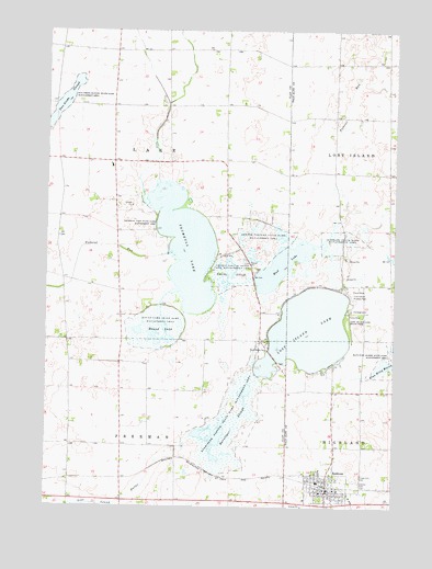
Ruthven, IA USGS Topographic Map
Click on map above to begin viewing in our Map Viewer.

This topographic map contains these locations and features:
Feature Name Type Latitude Longitude GNIS ID View Map
Barringer SloughGutN43.1469°W94.9322°454370View Map
Barringer Slough State Game Mgt AreaParkN43.1516°W94.9300°454371View Map
Blue Wing MarshLakeN43.1627°W94.8766°454715View Map
BridgewaterLocaleN43.1694°W94.9397°466311View Map
Bridgewater Post Office (historical)Post OfficeN43.1694°W94.9397°1944232View Map
Calvary CemeteryCemeteryN43.1315°W94.8873°455085View Map
City of RuthvenCivilN43.1301°W94.8985°2396460View Map
Clark FarmLocaleN43.2472°W94.9706°2727514View Map
Clay County Waterfowl Production Area of IowaParkN43.1963°W94.9371°2765245View Map
Crown Hill CemeteryCemeteryN43.1327°W94.8880°455742View Map
Dan Green Slough Wildlife Management AreaParkN43.2319°W94.9933°455783View Map
Deweys Pasture State Game Management AreaParkN43.1944°W94.9228°455901View Map
Eldridge FarmsLocaleN43.2425°W94.9247°2726809View Map
Farmer Co-op ElevatorLocaleN43.1305°W94.8994°1925489View Map
Grandview ParkParkN43.1655°W94.9214°457042View Map
Long Island Marsh Public Hunting AreaAreaN43.1833°W94.8867°467230View Map
Lost Island Golf ClubLocaleN43.1880°W94.8841°1925500View Map
Lost Island Huston ParkParkN43.1819°W94.8914°458629View Map
Lost Island LakeLakeN43.1712°W94.9059°458630View Map
Lost Island Lake State ParkParkN43.1733°W94.8922°458631View Map
Lost Island Post Office (historical)Post OfficeN43.1844°W94.9444°467214View Map
Lost Island Prairie Wetland Nature CenterParkN43.1825°W94.8930°1925499View Map
Mud LakeLakeN43.1884°W94.9157°459392View Map
Oppedahl State Game Management AreaParkN43.1944°W94.8961°459875View Map
Osher FarmsLocaleN43.2064°W94.9378°2728165View Map
Palo Alto Community Ambulance RuthvenBuildingN43.1296°W94.8999°2599918View Map
Palo Alto County Waterfowl Production AreaParkN43.1912°W94.8800°2765442View Map
Round LakeLakeN43.1696°W94.9614°460826View Map
Round Lake State Game Management AreaParkN43.1722°W94.9592°460828View Map
RuthvenPopulated PlaceN43.1291°W94.8992°460866View Map
RuthvenLocaleN43.1302°W94.8989°1925494View Map
Ruthven - Ayrshire Elementary SchoolSchoolN43.1317°W94.9021°2719801View Map
Ruthven - Ayrshire High SchoolSchoolN43.1317°W94.9021°1925498View Map
Ruthven City HallBuildingN43.1297°W94.8992°1925490View Map
Ruthven Community Care CenterHospitalN43.1297°W94.8861°1925493View Map
Ruthven Fire DepartmentBuildingN43.1292°W94.9038°2577295View Map
Ruthven Post OfficePost OfficeN43.1286°W94.8986°1925491View Map
Ruthven Public LibraryBuildingN43.1291°W94.9025°1925492View Map
Sacred Heart Catholic ChurchChurchN43.1297°W94.8947°1925495View Map
Smiths SloughSwampN43.1864°W94.9333°461710View Map
Smiths Slough State Game Management AreaParkN43.1872°W94.9336°461704View Map
Swan and Swan FarmsLocaleN43.1847°W94.9694°2727522View Map
Township of FreemanCivilN43.1260°W94.9733°467871View Map
Township of LakeCivilN43.2120°W94.9733°468179View Map
Trumbull LakeLakeN43.1933°W94.9502°462351View Map
Trumbull Lake State Game Management AreaParkN43.1930°W94.9486°462352View Map
United Methodist ChurchChurchN43.1291°W94.9011°1925497View Map
Zion Lutheran ChurchChurchN43.1297°W94.8958°1925496View Map

Note: Coordinates in the location and feature list above are referenced to NAD83 datum.


Copyright (C) 2008-2024 Ryan Niemi / Sunset Dynamics ... All Rights Reserved