TopoQuest Logo
Do you find TopoQuest useful?
Help keep TopoQuest running and adding new maps/features by donating!
Bitcoin:  19c7KJd3qBynnjoSw5npx9KScwjBe4ifkT
Litecoin:  LXs6TkuXGGXo1vDsWCkWVdjQX94eUKd6ui
Home View Maps Find Maps Find Places Resources & Links


Sainte Genevieve, Missouri Topographic Map

USGS Map Title: Sainte Genevieve, MO
USGS Map MRC: 37090H1
DRG (GeoTIFF) Download: o37090h1.tif


Neighboring USGS Topographic Map Quads:


  Bloomsdale, MO  
38090A2
 

  Prairie du Rocher, IL  
38090A1
 

  Evansville, IL  
38089A8
 

  Weingarten, MO  
37090H2
 

  Sainte Genevieve, MO  
37090H1
 

  Kaskaskia, IL  
37089H8
 

  Coffman, MO  
37090G2
 

  Minnith, MO  
37090G1
 

  Lithium, MO  
37089G8


Map MRC Location:

N38°
W91°
N38°
W90°
H8 H7 H6 H5 H4 H3 H2 H1
G8 G7 G6 G5 G4 G3 G2 G1
F8 F7 F6 F5 F4 F3 F2 F1
E8 E7 E6 E5 E4 E3 E2 E1
D8 D7 D6 D5 D4 D3 D2 D1
C8 C7 C6 C5 C4 C3 C2 C1
B8 B7 B6 B5 B4 B3 B2 B1
A8 A7 A6 A5 A4 A3 A2 A1
N37°
W91°
N37°
W90°

Sainte Genevieve, MO USGS 1:24K Topographic Map Preview:
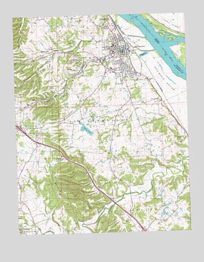
Sainte Genevieve, MO USGS Topographic Map
Click on map above to begin viewing in our Map Viewer.

This topographic map contains these locations and features:
Feature Name Type Latitude Longitude GNIS ID View Map
Beckett HillsRangeN37.8953°W90.0832°748753View Map
Big FieldAreaN37.9498°W90.0054°754928View Map
Bois Brule BottomFlatN37.9634°W90.0165°738181View Map
Bourbon School (historical)SchoolN37.9506°W90.0193°754924View Map
City of Ste. GenevieveCivilN37.9747°W90.0482°2396523View Map
Compressor StationLocaleN37.9806°W90.0996°742023View Map
Evening Shade School (historical)SchoolN37.9251°W90.0857°754922View Map
Fairview School (historical)SchoolN37.9742°W90.0732°754921View Map
Govro DamDamN37.9451°W90.1168°764925View Map
Govro LakeReservoirN37.9451°W90.1168°764926View Map
Holy Cross Lutheran CemeteryCemeteryN37.9804°W90.0557°742026View Map
Hook PondLakeN37.9341°W90.0735°758292View Map
Inkley Marble QuarryMineN37.9523°W90.1101°754935View Map
Kehl School (historical)SchoolN37.9981°W90.1079°754920View Map
Kinkle SchoolSchoolN37.9181°W90.0579°720635View Map
KSTZ-FM (St Genevieve)TowerN37.9937°W90.0557°759154View Map
Kunkle SchoolSchoolN37.9181°W90.0571°741459View Map
Lick HillSummitN37.8871°W90.0170°738124View Map
Lick Hill School (historical)SchoolN37.8934°W90.0093°736317View Map
Louis Bolduc HouseBuildingN37.9789°W90.0428°2462891View Map
MarloPopulated PlaceN37.9498°W90.1137°738125View Map
Marlo Mine and PlantMineN37.9576°W90.0993°754948View Map
Memorial ParkCemeteryN37.9795°W90.0501°754936View Map
Mississippi MineMineN37.9728°W90.0754°742024View Map
Mississippi SloughStreamN37.9862°W90.0284°738129View Map
Morning Sun School (historical)SchoolN37.8781°W90.1218°754923View Map
Moro SchoolSchoolN37.9959°W90.0121°413832View Map
MosherPopulated PlaceN37.9712°W90.0768°721737View Map
New BourbonPopulated PlaceN37.9498°W90.0209°741096View Map
North Gabouri CreekStreamN37.9826°W90.0396°736329View Map
Pere Marquette ParkParkN37.9976°W90.0562°742069View Map
Pointe Basse PlazaLocaleN37.9676°W90.0546°742664View Map
Quarreton School (historical)SchoolN37.9253°W90.0129°754925View Map
Quarry TownPopulated PlaceN37.9298°W90.0026°738122View Map
Saint Genevieve County Memorial HospitalHospitalN37.9693°W90.0545°2655083View Map
Saint Jude AcresPopulated PlaceN37.9626°W90.0390°736030View Map
Sainte GenevievePopulated PlaceN37.9814°W90.0418°727043View Map
Sainte Genevieve County Sheriff's OfficeBuildingN37.9660°W90.0557°2752213View Map
Sainte Genevieve Fire DepartmentBuildingN37.9698°W90.0529°2621167View Map
Sainte Genevieve Historic DistrictParkN37.9800°W90.0433°2463107View Map
Sainte Genevieve Police DepartmentBuildingN37.9782°W90.0476°2752533View Map
Sainte Genevieve Post OfficePost OfficeN37.9803°W90.0439°2783195View Map
Saints Phillip and James ChurchChurchN37.8781°W90.1240°742067View Map
South Gabouri CreekStreamN37.9803°W90.0373°726760View Map
Ste Genevieve Flying ClubAirportN37.9864°W90.0429°758903View Map
Township of Sainte GenevieveCivilN37.9465°W90.1147°767326View Map
Valle SpringSpringN37.9642°W90.0450°738127View Map
Valle Spring BranchStreamN37.9642°W90.0451°738128View Map
Valle Spring CemeteryCemeteryN37.9617°W90.0468°754946View Map
Valle Spring ChurchChurchN37.9603°W90.0468°742025View Map

Note: Coordinates in the location and feature list above are referenced to NAD83 datum.


Copyright (C) 2008-2024 Ryan Niemi / Sunset Dynamics ... All Rights Reserved